Forecast for the Moab Area Mountains

Eric Trenbeath
Issued by Eric Trenbeath for
Monday, March 7, 2022
NEW SNOW CONTINUES TO ACCUMULATE AND CONDITIONS REMAIN DANGEROUS!
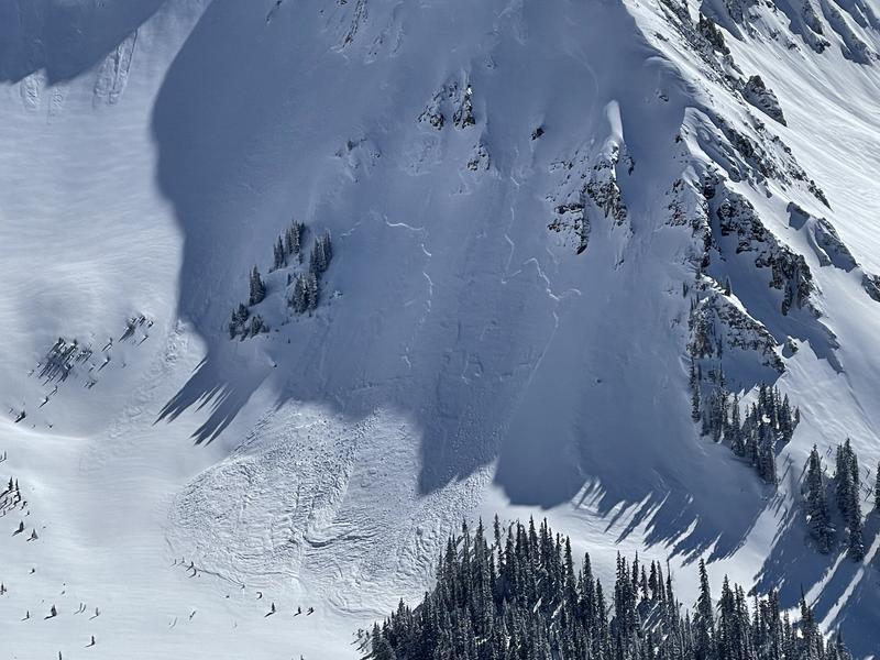
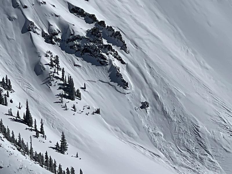
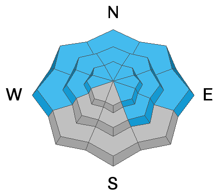
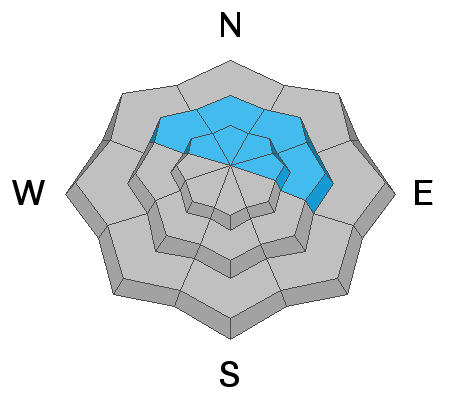
The avalanche danger is CONSIDERABLE and human triggered avalanches 2'-3' deep are likely on all steep slopes facing NW-N-NE-E. In these areas, new and wind drifted snow has dangerously overloaded a buried persistent weak layer and all steep, northerly facing terrain should be avoided. This weak layer can also be found on slopes facing W and SE but sun and warm temperature last week have made avalanches on this weak layer less likely. A MODERATE avalanche danger exists on these slopes.
All other steep terrain has a MODERATE avalanche danger, and soft slab human triggered avalanches involving the new snow are possible. Look for signs of instability such as cracking in the snow surface and utilize test slopes to see how the snow is behaving. Consider south facing terrain without overhead, steep inclines as a safer option today.
Low
Moderate
Considerable
High
Extreme
Learn how to read the forecast here
Special Announcements
Road Conditions: Grand County will be plowing this morning and the gate will be closed. With all of the recent snow it's going to take awhile and I wouldn't plan on access until after 1:00 at the earliest.
Grooming: Trails were packed into Gold Basin yesterday and are now covered in 4"-6" of new snow.
Weather and Snow
6:00 a.m. weather data:
24 Hour Snow 11" 72 Hour Snow 27" Base Depth at Gold Basin 72" Wind W 5-10 Temp 6F
Ho hum, another 6"! The mountains picked up an additional 4"-6" of low density snow last night on top of another 5" that fell during the day yesterday. This brings us up to 27" of new snow and over 2.0" of SWE. Today, look for mostly cloudy skies and a chance for snow showers as a mid level low pressure system moves through the region. Westerly winds will be light and high temps will be in the upper teens. We'll see a break on Tuesday, with sunny skies and warmer temps before yet another system moves through Wed-Thu followed by a clear and dry weekend. The mid week storm doesn't look real promising, but long range model runs show precipitation kicking in again next week. Bring on the Miracle March!
Gold Basin SNOTEL site (10,000')
Storm Totals in Gold Basin
Wind Station on Pre Laurel Peak (11,700')
Snowpack
Snow continues to pile up on a buried persistent weak layer of loose, sugary facets that formed during the extended dry period. In our travels yesterday, Brian Murdock and I continued to experience widespread collapsing on northerly facing slopes near treeline and below which is where we have the weakest underlying snow. Tim Mathews and company were out covering ground yesterday (read their observation here) and they also reported collapsing, poor snowpack structure, recent avalanches, as well excellent turning and riding on south facing terrain. Consider south facing terrain for safer riding options. Above treeline, the distribution of the weak layer is much more variable however, recent and wind drifted snow have created their own problems up there, and the bottom line is that all steep, northerly facing terrain should be avoided.
Recent Avalanches
Local observers and I noted several natural avalanches in Gold Basin yesterday. Above treeline, avalanche type ran the full spectrum from dry loose, to soft storm and wind slab, to avalanches failing on the buried persistent weak layer. This is consistent with the variable distribution of the weak layer above treeline which makes conditions tricky up there. Crowns I observed near treeline and below all appeared to have failed on the persistent weak layer.
Avalanches failing on a persistent weak layer above treeline in Gold Basin. Tim Mathews photos.
Ad
Avalanche Problem #1
Persistent Weak Layer
Type
Location
Likelihood
Size
Description
20"-27" of new snow at around 2.0" SWE has been added to our buried persistent weak layer and conditions remain dangerous. This buried weak layer of loose, sugary faceted snow is present on W-N-SE aspects and is now buried by 2' -3' of snow. Sun and warm temps last week have tempered it somewhat on slopes that have seen more sun, but it's still well preserved on shady slopes. The most widespread distribution of this weak layer is on slopes facing NW-N-NE-E near treeline and below. Above treeline the distribution is much more variable but it's not a game worth playing right now, and all steep, northerly facing slopes should be considered dangerous with human triggered avalanches 2'-3' deep likely.
This video was taken on Saturday, March 5, up to an additional 16" of snow has fallen since then.
Avalanche Problem #2
Wind Drifted Snow
Type
Location
Likelihood
Size
Description
Winds have been mostly calm for the past 36 hours and instabilities are starting to settle out of the most recently deposited wind drifts. However, recent drifts have added more stress to the buried persistent weak layer and the bottom line travel advice remains the same - all steep, northerly facing slopes should be avoided.
Avalanche Problem #3
New Snow
Type
Location
Likelihood
Size
Description
Soft slab avalanches within the new snow remain possible on steep slopes on all aspects today. South facing slopes have less snow on them because of prevailing winds but any steep slope with more than about 12" of snow should be considered suspect. Utilize smaller tests slopes and see how the snow is behaving and look for signs of instability such as cracking in the snow surface.
General Announcements
Who's up for some free avalanche training? Get a refresher, become better prepared for an upcoming avalanche class, or just boost your skills. Go to https://learn.kbyg.org/ and scroll down to Step 2 for a series of interactive online avalanche courses produced by the UAC.
This forecast is from the U.S.D.A. Forest Service, which is solely responsible for its content. This forecast describes general avalanche conditions and local variations always occur.