Forecast for the Moab Area Mountains

Eric Trenbeath
Issued by Eric Trenbeath for
Monday, March 6, 2023
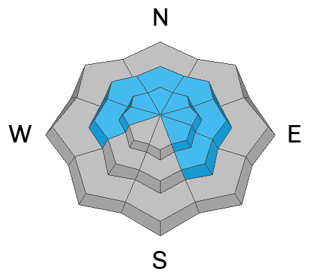
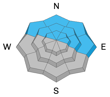
A MODERATE danger exists for human triggered avalanches involving slabs of wind drifted snow on steep slopes near treeline and above that face W-N-SE. Drifts will be deepest and most widespread on slopes with a northerly aspect.
A MODERATE danger also exists on northerly aspects at all elevations where human triggered avalanches 1'-3' deep failing on a buried persistent weak layer are possible.
Most other terrain has generally LOW danger.

Backcountry travelers should avoid wind drifted slopes and be able to determine the absence of a weak layer before committing to terrain steeper than 30 degrees.
Low
Moderate
Considerable
High
Extreme
Learn how to read the forecast here
Special Announcements
10:00 am update. It sounds like Grand County is doing work on the road and the gate is closed.
Grooming: Matt groomed all trails on Saturday.
To help you safely enjoy the backcountry, the UAC team is constantly evaluating and implementing new programs and technologies. Donate to the Spring Campaign to help our team implement innovative tools and better provide you with the information you rely on.
Weather and Snow
6:00 a.m. Snow and Weather Data
24 Hour Snow 0" 72 Hour Snow 0" Season Total Snow 229" Base Depth at Gold Basin 85"
Winds on Pre Laurel Peak SSE 30-40 G48 Temp 23F

Weather
In the words of local observer Travis Nauman, "Uncle Gusty is getting busy." By Saturday evening southerly wind gusts were hitting 60 mph. Yesterday's winds were lighter than expected, blowing in the 20-30 mph range from the SW for most of the day, but averages increased by about 10 mph around 8:00 p.m. and have continued since. Conditions will remain blustery today with SW winds blowing in the 30-35 mph range along ridge tops. Skies will be mostly sunny and high temps will rise into the low 30's. A more northerly storm track will leave us high and dry through the week though we will see periods of cloudiness and, of course, wind.

General Conditions
It's a complex landscape out there. 10" of new snow fell last week and strong winds have been actively blowing it around and will continue to do so. Exposed slopes are getting scoured and stripped, while fresh slabs of wind drifted snow are being deposited on leeward aspects. Perhaps even more concerning is the continued presence of buried weak layers with older slabs on top of them, and in our travels on Saturday we found them to be more reactive then anticipated. Travis Nauman and company were out and about Saturday as well and found similar conditions. See their observation here.
Check out this video of conditions on Saturday.

Snowpack and Weather Data
Gold Basin Storm Stake (10,000')
Gold Basin SNOTEL site (10,000')
SNOTEL site near Geyser Pass Winter Trailhead (9600')
Wind Station on Pre-Laurel Peak (11,400')
NWS forecast for the La Sal Mountains.
Recent Avalanches
A few isolated wind slab releases were noted over the weekend. See the La Sal avalanche database here.
Ad
Avalanche Problem #1
Wind Drifted Snow
Type
Location
Likelihood
Size
Description
Strong southerly winds continue to blow and drift snow forming new slabs on top of old. Fresh drifts are easier to discern - they will likely be shallow and you may see cracking around your skis. Fresh drifts will be found on the leeward sides of ridge crests and terrain features such as gully walls and sub-ridges. Old, hard wind slabs are harder to identify and they may not release until you get well out on them. In general, you'll want to avoid steep slopes that have a smooth, rounded "fat" appearance or that sound hollow underneath. On slopes with a northerly aspect accumulating drifted snow has formed slabs 2'-3' thick that may also be overlying weak layers underneath.
Avalanche Problem #2
Persistent Weak Layer
Type
Location
Likelihood
Size
Description
In our travels on Saturday, we unfortunately discovered that the Valentine's layer we have been tracking has suddenly become reactive, likely due to incremental loading over the past several weeks. Travis Nauman confirmed this. He also observed areas with weak faceted snow near the surface, as well as areas where the underlying snowpack looked strong. Wind drifted snow has added more stress to this complicated picture and for now we need to assume that all northerly facing slopes steeper than 30 degrees are suspect, and that human triggered avalanches failing 1'-3' deep on a buried persistent weak layer are possible.
Photo illustrates a weak layer of faceted snow under a slab that we found over in the Corkscrew Glades on Saturday (10,100' NW aspect). An extended column test produced results of ECTP 21.
On a nearby slope we didn't find the upper faceted layer, but the Valentine's layer was alive and well producing a failure with a score of ECTP 26. Careful slope analysis is imperative right now, and you'll need to dig down close to 4' to determine the presence or absence of a weak layer.
Additional Information
SNOTEL data from the LSMU1 plot near the Geyser Pass Trailhead is near off the chart at 167% of average.
General Announcements
This forecast is from the U.S.D.A. Forest Service, which is solely responsible for its content. This forecast describes general avalanche conditions and local variations always occur. This forecast will be updated by 7:30 tomorrow morning.