Forecast for the Moab Area Mountains

Dave Garcia
Issued by Dave Garcia for
Tuesday, March 7, 2023
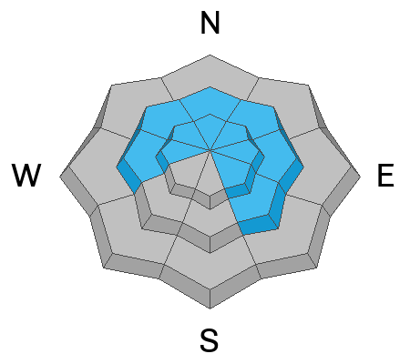
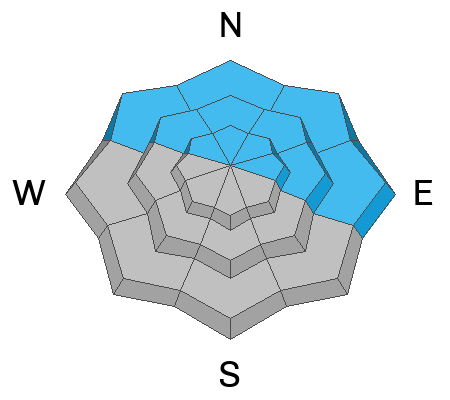
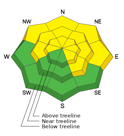
The avalanche danger is MODERATE. It is POSSIBLE to trigger an avalanche in wind drifted snow near treeline and above on slopes that face W-N-SE. Drifts will be deepest and most widespread on slopes with a northerly aspect.
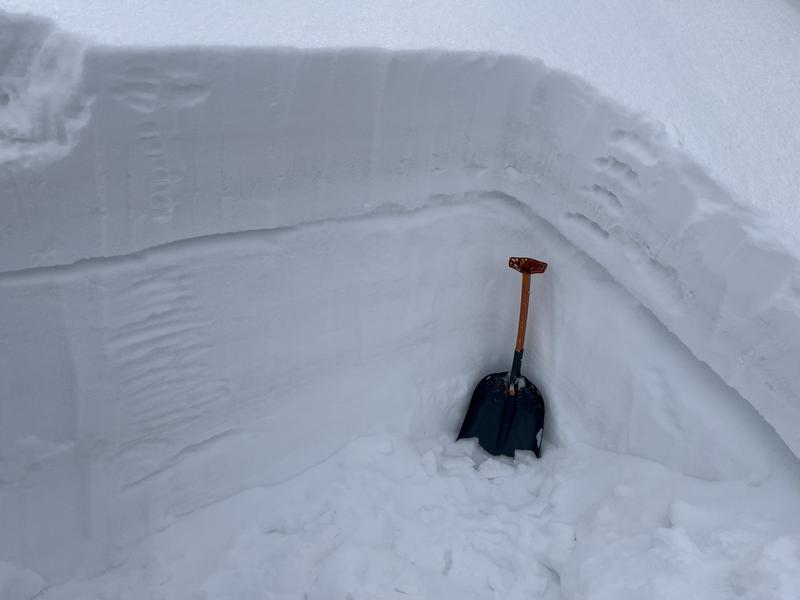
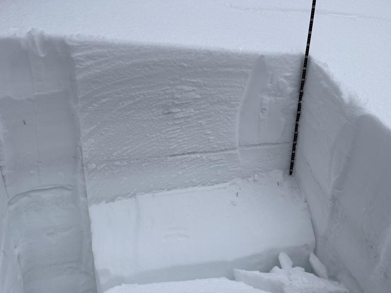
It is also POSSIBLE to trigger avalanches failing on buried persistent weak layers on all steep slopes that face NW-N-NE-E. These avalanches can be 1-3 feet deep.
Most other terrain has generally LOW danger.

Backcountry travelers should avoid wind drifted slopes and be able to determine the absence of a weak layer before committing to terrain steeper than 30 degrees.
Low
Moderate
Considerable
High
Extreme
Learn how to read the forecast here
Special Announcements
10:30 a.m. Grand County has finished working and the gate is open.
Grooming: Matt groomed all trails on Saturday.
To help you safely enjoy the backcountry, the UAC team is constantly evaluating and implementing new programs and technologies. Donate to the Spring Campaign to help our team implement innovative tools and better provide you with the information you rely on.
Weather and Snow
6:00 a.m. Snow and Weather Data
24 Hour Snow 0" 72 Hour Snow 0" Season Total Snow 229" Base Depth at Gold Basin 85"
Winds on Pre Laurel Peak S 20-25 Temp 20

Weather
Southerly winds continue to blow. Throughout the day yesterday and overnight, wind speeds were sustained in the 30's and low 40's. They will back off slightly today and blow 25-30 out of the SW. This morning we should see high clouds with gradual clearing by the afternoon. Scattered clouds and wind is the name of the game until Thursday when the winds finally back off. Clouds will build again on Friday and the next chance for a storm comes this weekend.

General Conditions
It's a complex landscape out there. 10" of new snow fell last week and strong winds have been actively blowing it around and will continue to do so. Exposed slopes are getting scoured and stripped, while fresh slabs of wind drifted snow are being deposited on leeward aspects. It is still possible to find soft powder if you can get out of the wind zone. We found good soft turns in our travels yesterday, but we really had to hunt for it. Weak layers still exist in the top meter of the snowpack and are reactive in recent snow pit tests.
Check out this video of conditions on Saturday.

Snowpack and Weather Data
Gold Basin Storm Stake (10,000')
Gold Basin SNOTEL site (10,000')
SNOTEL site near Geyser Pass Winter Trailhead (9600')
Wind Station on Pre-Laurel Peak (11,400')
NWS forecast for the La Sal Mountains.
Recent Avalanches
A few isolated wind slab releases were noted over the weekend. See the La Sal avalanche database here.
Ad
Avalanche Problem #1
Wind Drifted Snow
Type
Location
Likelihood
Size
Description
Strong Southerly winds will not quit, and fresh slabs will continue to form above treeline on Northerly aspects. Fresh drifts are easier to discern - they will likely be shallow and you may see cracking around your skis. Fresh drifts will be found on the leeward sides of ridge crests and terrain features such as gully walls and sub-ridges. There are plenty of old hard drifts that exist in the alpine as well. These older wind slabs are harder to identify and they may not release until you get well out on them. In general, you'll want to avoid steep slopes that have a smooth, rounded "fat" appearance or that sound hollow underneath. On slopes with a northerly aspect accumulating drifted snow has formed slabs 2'-3' thick that may also be overlying weak layers underneath.
Avalanche Problem #2
Persistent Weak Layer
Type
Location
Likelihood
Size
Description
In our recent travels we have been finding reactive weak layers in the upper meter of the snowpack. The distribution of these layers is spotty - they exist in some places and not in others. Regardless, these layers are capable of producing avalanches. So if you are considering riding on Northerly aspects you need to get out your shovel and look for weak, sugary, faceted snow. I am personally not riding on slopes steeper than 30 degrees that harbor any of these weak layers.
Photo illustrates a weak layer of faceted snow under a slab that we found over in the Corkscrew Glades on Saturday (10,100' NW aspect). An extended column test produced results of ECTP 21.
On a nearby slope we didn't find the upper faceted layer, but the Valentine's layer was alive and well producing a failure with a score of ECTP 26. Careful slope analysis is imperative right now, and you'll need to dig down close to 4' to determine the presence or absence of a weak layer.
Additional Information
General Announcements
This forecast is from the U.S.D.A. Forest Service, which is solely responsible for its content. This forecast describes general avalanche conditions and local variations always occur. This forecast will be updated by 7:30 tomorrow morning.