Forecast for the Moab Area Mountains

Eric Trenbeath
Issued by Eric Trenbeath for
Friday, March 4, 2022
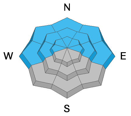
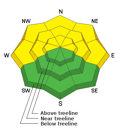
The avalanche danger is MODERATE and human triggered avalanches 1'-2' deep, failing on a buried persistent weak layer of sugary, faceted snow are possible. You are most likely to encounter this problem on steep slopes facing the north half of the compass, with the highest likelihood existing right around treeline. With snow in the forecast through the weekend, expect increasing danger and a higher likelihood for triggering avalanches on this buried weak layer as new and wind drifted snow accumulate.
Low
Moderate
Considerable
High
Extreme
Learn how to read the forecast here
Special Announcements
Road Conditions: The road is plowed. AWD and good tires are recommended. Warms temps are making things quite sloppy.
Grooming: LUNA groomed into Gold Basin on Tuesday. Follow LUNA on Instagram @luna_moab.
Weather and Snow
6:00 a.m. weather data:
24 Hour Snow 0" 72 Hour Snow 0" Base Depth at Gold Basin 49" Wind SW 10-20 Temp 34F
Overnight temps have again remained warm and are hovering right around freezing this morning at 10,000'. A low pressure system spinning off the coast of Southern California will move inland today. This will be the first in a series of systems to affect the region over the next several days. SW winds will be on the increase today with light snow showers developing by late afternoon. A weak cold front tonight will bring the best chance for snow with 3"-5" possible by mid-morning on Saturday. Then we'll see a lull in the action before the next storm arrives Saturday evening. This system has a little more moisture to work with and I'm thinking 5"-7" are likely by Sunday. Optimistically, I'm hoping for a foot of snow this weekend. A final, weaker system moves through on Monday.
NWS Weather Forecast for the La Sal Mountains
Gold Basin SNOTEL site (10,000')
Storm Totals in Gold Basin
Wind Station on Pre Laurel Peak (11,700')
Snowpack
Sun and very warm temps this week have had their way with exposed surfaces but you can still find soft settled powder in sheltered locations. They've also helped to strenghten and consolidate the snowpack. Dave Garcia and Nate Ament were out hunting for powder and reactive weak layers yesterday. Read their observation here. They continued to experience collapsing in sheltered, flat terrain but not on any of the test slopes they walked on. The persistent weak layer of loose, sugary, facets is still clearly identifiable beneath a slab, but a stability test showed it to be non-reactive. This indicates that there are probably some steeper slopes you can venture on to, but with the poor snowpack structure, I'm still not comfortable with the situation. With snow in the forecast this weekend there is a pretty good likelihood that this layer will again become reactive. Let's sit tight for a few days and see how things shake out.
Ad
Avalanche Problem #1
Persistent Weak Layer
Type
Location
Likelihood
Size
Description
A persistent weak layer of faceted snow sits beneath a well consolidated slab 1'-2' thick. Time and warm temps have helped to strengthen the snowpack and signs of instability are lessening. Nevertheless, the poor snowpack structure indicates that it's still possible to trigger an avalanche, primarily on steep slopes facing NW-N-E with the weakest underlying snow existing right around treeline and below. Above treeline, this weak layer is not as widespread but this just makes it more tricky. For now, I'm still not willing to trust any steep, northerly facing terrain. Let's keep it dialed back and see how this next round of snow stacks up.
Additional Information
Dave Garcia's snow profile from a north aspect at 10,400'. Last week's storm snow starts at 100 cm. The layer of weak, faceted snow that formed during the period of extended high pressure starts at 75 cm. There is also a weak faceted layer at around 55 cm, and the base of the snowpack from 0-30 cm is weak, sugary, depth hoar. When we look at pit profiles we are looking for harder layers over weak layers. The further a layer is illustrated moving to the left, the harder it is. The bottom line here is that though the snowpack is currently non-reactive, it has poor structure in this relatively shallow location.
General Announcements
Who's up for some free avalanche training? Get a refresher, become better prepared for an upcoming avalanche class, or just boost your skills. Go to https://learn.kbyg.org/ and scroll down to Step 2 for a series of interactive online avalanche courses produced by the UAC.
This forecast is from the U.S.D.A. Forest Service, which is solely responsible for its content. This forecast describes general avalanche conditions and local variations always occur.