Forecast for the Moab Area Mountains

Eric Trenbeath
Issued by Eric Trenbeath for
Thursday, March 3, 2022
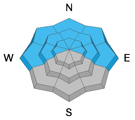
The avalanche danger is MODERATE but triggering an avalanche 1'-2' deep on a buried persistent weak layer of sugary, faceted snow remains a very real possibility. You are most likely to encounter this problem on steep slopes facing the north half of the compass, with the highest likelihood existing right around treeline. I'm personally not trusting steep, northerly facing terrain yet.
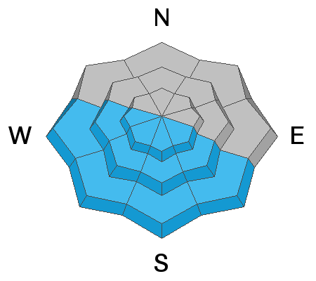
As the day heats up we will again need to be on the lookout for wet avalanches and a MODERATE danger exists on all sun exposed slopes. Signs of instability include rollerballs, pinwheels, and sloppy wet snow. Stay off of and out from under steep slopes when these signs are present.
Low
Moderate
Considerable
High
Extreme
Learn how to read the forecast here
Special Announcements
Road Conditions: The road is plowed. AWD and good tires are recommended. Warms temps are making things quite sloppy.
Grooming: LUNA groomed into Gold Basin on Tuesday. Follow LUNA on Instagram @luna_moab.
Weather and Snow
6:00 a.m. weather data:
24 Hour Snow 0" 72 Hour Snow 0" Base Depth at Gold Basin 49" Wind SW 5-15 Temp 34F
We did not get a re-freeze last night. Clouds will be on the increase today as upper level moisture ahead of a low pressures system moves in. Today, look for partly sunny skies, light SW winds, and high temps in the mid 40's. Friday will kick off the beginning of a stormy weekend as a complex low pressure pattern sends several bursts of energy through the region. We should see snow from the first wave on Friday night with perhaps a more potent system on Sat into Sun.
NWS Weather Forecast for the La Sal Mountains
Gold Basin SNOTEL site (10,000')
Storm Totals in Gold Basin
Wind Station on Pre Laurel Peak (11,700')
Snowpack
Sun and very warm temps this week have had their way with exposed surfaces but without a solid re-freeze crusts will be punchy this morning. Sheltered, northerly aspects are where you will find the best snow, unfortunately, these are the same areas where you are most likely to find a problem. Though warm conditions this week have helped to strengthen and consolidate the snowpack, a real possibility still exists for triggering an avalanche 1'-2' on a buried persistent weak layer of weak, sugary, facets. This problem is becoming more isolated to slopes facing NW-N-NE but outlying problems may still exist on W and E facing slopes. The weakest snow can be found on shady slopes right around treeline and below, and I expect we will continue to experience signs of instability such as collapsing and whumphing in these areas. The bottom line is that I'm not ready to trust this weak layer, and with snow in the forecast this weekend, I'm anticipating another round of dangerous conditions.
Ad
Avalanche Problem #1
Persistent Weak Layer
Type
Location
Likelihood
Size
Description
We've experienced a week of sensitive and active avalanche conditions as new snow was piled on top of weak, near surface facets that formed during the extended period of high pressure. This persistent weak layer now sits beneath a well consolidated slab 1'-2' thick. Time and warm temps have helped to strengthen the snowpack but signs of instability such as collapsing and whumphing continue to present themselves. It is definitely still possible to trigger an avalanche, primarily on steep slopes facing NW-N-E with the weakest underlying snow existing right around treeline and below. Above treeline, this weak layer is not as widespread but this just makes it more tricky. For now, I'm still not willing to trust any steep, northerly facing terrain. Let's keep it dialed back and see how this next round of snow stacks up.
Avalanche Problem #2
Wet Snow
Type
Location
Likelihood
Size
Description
With a lack of an overnight re-freeze, and unseasonably warm temps on tap again today, continue to be mindful of the potential for loose, wet avalanches as the day heats up. Signs of instability include rollerballs, pinwheels, and sloppy wet snow. Get off of and out from under steep, sun exposed slopes when these signs are present. A rarer occurrence would be wet slab avalanches. These occur when there is liquid water in the snowpack, generally after a few days with no refreeze. In the La Sals, steep, rocky, westerly facing slopes are where we generally see these first. Harder to predict, signs of instability remain the same.
General Announcements
Who's up for some free avalanche training? Get a refresher, become better prepared for an upcoming avalanche class, or just boost your skills. Go to https://learn.kbyg.org/ and scroll down to Step 2 for a series of interactive online avalanche courses produced by the UAC.
This forecast is from the U.S.D.A. Forest Service, which is solely responsible for its content. This forecast describes general avalanche conditions and local variations always occur.