Donate to the 2024 Spring Campaign to help rebuild the UAC website.

Forecast for the Moab Area Mountains

Eric Trenbeath
Issued by Eric Trenbeath for
Saturday, March 5, 2022
HEADS UP, DANGEROUS AVALANCHE CONDITIONS HAVE RETURNED!
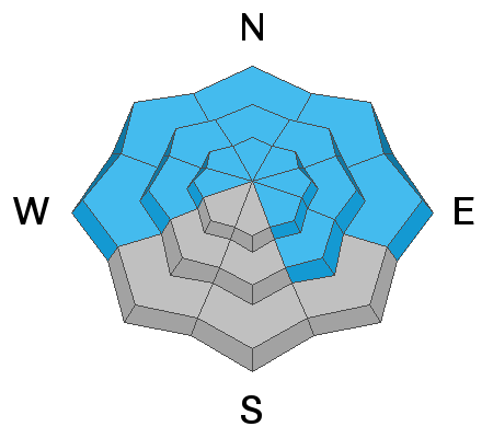
The avalanche danger is CONSIDERABLE and human triggered avalanches 2'-3' deep are likely on all steep slopes facing NW-N-NE-E. In these areas, new and wind drifted snow has dangerously overloaded a buried persistent weak layer and all steep, northerly facing terrain should be avoided. This weak layer can also be found on slopes facing W and SE but sun and warm temperature this past week have made avalanches on this weak layer less likely and a MODERATE avalanche danger exists on these slopes.
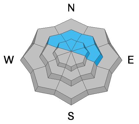
All other steep terrain has a MODERATE avalanche danger, and human triggered avalanches involving the new snow are possible. Backcountry travelers need to have excellent route finding and snow stability analysis skills out there today.
Low
Moderate
Considerable
High
Extreme
Learn how to read the forecast here
Special Announcements
Road Conditions: Expect up to 6" of new snow on the upper portion of the road. AWD and good tires are required.
Grooming: Trails will be covered with 8"-10" of fresh snow today.
Weather and Snow
6:00 a.m. weather data:
24 Hour Snow 10" 72 Hour Snow 10" Base Depth at Gold Basin 59" Wind SW 15-20 Temp 19F
Back to winter and I think we may be the big winners with 10" of new snow at 1.0" Snow Water Equivalent (SWE)! 8" has fallen since 10:00 p.m. last night. SW winds ahead of the front yesterday averaged 20-25 mph with gusts to 40. They backed off a bit overnight. We should see a lull in the action today before the next system kicks in this afternoon. This was supposed to be the more potent storm but it will be hard to top last night's totals. 6"-8" more through Sunday seem likely.
NWS Weather Forecast for the La Sal Mountains
Gold Basin SNOTEL site (10,000')
Storm Totals in Gold Basin
Wind Station on Pre Laurel Peak (11,700')
Snowpack
A fresh load of new and wind drifted snow has been added to our weak snowpack once again stressing the buried persistent weak layer of loose, sugary facets that formed during the extended dry period. Dangerous conditions exist with human triggered avalanches 2'-3' deep likely on steep, northerly facing slopes. The weakest underlying snow can be found near treeline and below. Above treeline, the distribution of the weak layer is much more variable however, new and wind drifted snow create their own problems up there today, and the bottom line is that all steep, northerly facing terrain should be avoided.
Ad
Avalanche Problem #1
Persistent Weak Layer
Type
Location
Likelihood
Size
Description
An inch of water weight has been rapidly added to our buried persistent weak layer and conditions are once again dangerous. This buried weak layer of loose, sugary faceted snow is present on W-N-SE aspects and is now buried by 2' -3' of snow. Sun and warm temps this week have tempered it somewhat on slopes that have seen more sun, but it's still well preserved on shady slopes near treeline and below. Above treeline it's distribution is much more variable but this is not a game worth playing right now, and all steep, northerly facing slopes should be considered dangerous with human triggered avalanches 2'-3' deep likely.
Avalanche Problem #2
Wind Drifted Snow
Type
Location
Likelihood
Size
Description
Unstable, fresh deposits of wind drifted snow will be found along the leeward sides of ridge crests and terrain features, primarily on slopes facing NW-N-NE-E. Fresh drifts will add more stress to the buried persistent weak layer and the bottom line travel advice remains the same - all steep, northerly facing slopes should be avoided.
Avalanche Problem #3
New Snow
Type
Location
Likelihood
Size
Description
Avalanches within the new snow will be possible on steep slopes on all aspects today that have more than about 8" of new snow on them.
These could come in the form of either loose snow or sensitive soft slabs. South facing slopes have less snow on them because of prevailing winds but any steep slope with more than about 8" of snow should be considered suspect. Utilize smaller tests slopes and see how the snow is behaving and look for signs of instability such as cracking in the snow surface.
Additional Information
Dave Garcia's snow profile from a north aspect at 10,400'. Last week's storm snow starts at 100 cm. The layer of weak, faceted snow that formed during the period of extended high pressure starts at 75 cm. There is also a weak faceted layer at around 55 cm, and the base of the snowpack from 0-30 cm is weak, sugary, depth hoar. When we look at pit profiles we are looking for harder layers over weak layers. The further a layer is illustrated moving to the left, the harder it is. The bottom line here is that though the snowpack is currently non-reactive, it has poor structure in this relatively shallow location.
General Announcements
Who's up for some free avalanche training? Get a refresher, become better prepared for an upcoming avalanche class, or just boost your skills. Go to https://learn.kbyg.org/ and scroll down to Step 2 for a series of interactive online avalanche courses produced by the UAC.
This forecast is from the U.S.D.A. Forest Service, which is solely responsible for its content. This forecast describes general avalanche conditions and local variations always occur.