Forecast for the Moab Area Mountains

Eric Trenbeath
Issued by Eric Trenbeath for
Sunday, March 31, 2019
Today the danger is MODERATE for avalanches involving the new snow on slopes steeper than about 35 degrees at mid and upper elevations. Expect fast running sluffs on a variety of slick surfaces. Utilize slope cuts, and choose terrain wisely with regard for consequences. Even a small sluff could sweep you over a cliff or push you into trees. At low elevations, and in slopes less steep than about 35 degrees, the avalanche danger is generally LOW.
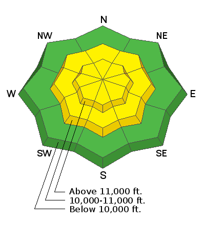
Low
Moderate
Considerable
High
Extreme
Learn how to read the forecast here
Special Announcements
Utah has a rich history of avalanches. From the earlier mining days of Alta to the start of avalanche research and snow science in the US in Little Cottonwood Canyon in 1939. Snowpack and weather data has been collected from the Alta Guard Station every year since making it the longest snow plot history in the US. These roots made the UAC an early leader in avalanche education and forecasting.
Couple of new interesting things to read and listen to: (1) The latest blog by Drew "Roping the Wind (Slab)", and (2) UAC podcast featuring Lynne Wolfe - guide, avalanche educator, editor of The Avalanche Review, mentor, role model. This is a can't-miss episode!
Weather and Snow
A period of intense snowfall began around 3:00 a.m. and it has caused the sensor in Gold Basin to go haywire. My best estimate is 8" as of 7:00 a.m. Another 2"-4" are possible today. NE winds have been light overnight and will remain so throughout the day. High temps today will rise to near freezing and it's currently 19 degrees at 10,000'. Skies will begin to clear late this afternoon and evening with a a sunny day on tap for tomorrow. A progressive pattern is setting up for the week with another storm system on track for Tue-Wed, followed by another on Friday.
In our travels yesterday we found a variety of wind and sun crusts, and not much soft snow left. The new snow will provide a nice refresh on top of a highly variable snow surface.
New snow totals in Gold Basin (10,000')
Snotel totals at the Geyser Pass Trailhead (9600')
Winds at 11,000 feet on Abajo Peak (11,330') about 45 miles south.
National Weather Service point forecast.
Recent Avalanches
No new avalanches have been reported. For a list of avalanches this season go here.
Ad
Avalanche Problem #1
New Snow
Type
Location
Likelihood
Size
Description
Avalanches within the new snow will be your primary concern today, particularly if you are stepping it up into steep, upper elevation terrain. I'm expecting fast running sluffs due to the variety of slick surfaces underneath. These new snow sluffs could entrain a fair amount of snow once they get going. Utilize slope cuts, and choose your terrain wisely with regard for consequences such as being swept over a cliff or into trees.
General Announcements
Your information can save lives. If you see anything we should know about, please help us out by submitting snow and avalanche observations HERE. You can also call me at 801-647-8896, or send me an email: [email protected].
Support the UAC through your daily shopping. When you shop at Smith's, or online at REI, Backcountry.com, Patagonia, NRS, Amazon, eBay by clicking on these links, they donate a portion of your purchase to the UAC. If you sell on eBay, you can have your See our Affiliate Page for more details on how you can support the UAC when you shop
This forecast is from the U.S.D.A. Forest Service, which is solely responsible for its content. This forecast describes general avalanche conditions and local variations always occur.