Forecast for the Moab Area Mountains

Mark Staples
Issued by Mark Staples for
Monday, March 18, 2019
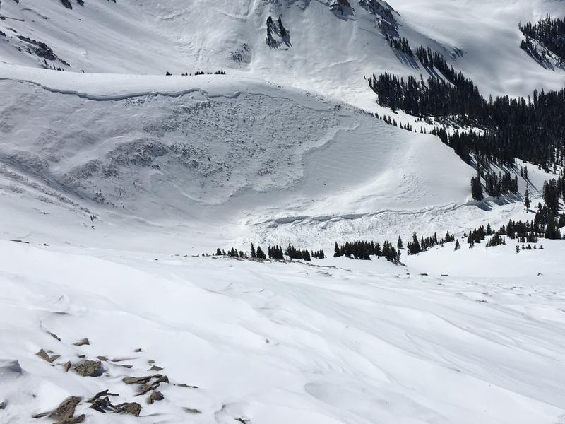
Today the avalanche danger is CONSIDERABLE at upper elevations where dangerous avalanche conditions exist. Triggering a monster avalanche will not be likely, but deadly consequences make the situation dangerous. Triggering one of these slides is possible but less likely at mid elevations where the danger is MODERATE.

The danger is MODERATE at low elevations where wet avalanches are possible especially on southerly facing and west facing slopes.
Low
Moderate
Considerable
High
Extreme
Learn how to read the forecast here
Special Announcements
The road to Geyser Pass Trailhead will closed today while crews finish plowing snow off the road.
Photo below of a bulldozer from the Manti-La Sal National Forest pushing snowbanks back to make room for Grand County to plow the road with their graders.
Weather and Snow
This morning under clear skies, temperatures dropped into the upper teens and low 20s F. Yesterday temperatures reached the low 40s F at low elevations and near 30 degrees above 11,000 feet.
Winds were calm yesterday but increased from the SW this morning and were blowing 14 mph gusting 17 mph on Abajo Peak.
Today, temperatures will rise again into the 40s F at lower elevations and 30s F at upper elevations. There will be a few clouds in the sky today and winds will generally blow from the SW at 5-10 mph with some gusts of 15 mph.
The snow on many slopes has been going through a melt-freeze cycle for the last three days.
Looking ahead, today and Tuesday will have sunny skies. More precipitation arrives late Wednesday. By Thursday morning there could be up to an inch of water and maybe a foot of snow.
Total snow depth in Gold Basin at 10,000 feet is 8 feet 7 inches.

New snow totals in Gold Basin (10,000')
Snotel totals at the Geyser Pass Trailhead (9600')
Winds at 11,000 feet on Abajo Peak (11,330') about 45 miles south.
National Weather Service point forecast.
Recent Avalanches
Following the storm on Tuesday/Wednesday there were many avalanches. Some broke within the new snow. However, many broke 1/4 to 1/2 mile wide at the ground. See the full list of avalanches we have cataloged so far HERE.
Below is a photo of a slope called Noriega's Face (photo W. Holdman)
Below is a photo of the Talking Mountain Cirque
Another slide in Gold Basin
Ad
Avalanche Problem #1
Persistent Weak Layer
Type
Location
Likelihood
Size
Description
Avalanches breaking on persistent weak layers buried deep in the snowpack are a challenging avalanche problem to assess. Knowing the likelihood that a human can trigger one is really tough. It has been 5 days since the storm ended that caused a widespread natural avalanche cycle. Because these layers are buried so deeply, it will be tough to trigger an avalanche like ones that occurred just after the storm; however, the consequences would be deadly.
Personally, I would not be comfortable riding in avalanche terrain feet until significant time had passed since recent loading. How much time? Certainly more than 5 days. Another storm may arrive on Wednesday and could add additional weight and stress to the snowpack to raise the likelihood of triggering one of these slides.
Most of these types of avalanches occurred above 11,000 feet. Noriega's Face is a notable exception.
Avalanche Problem #2
Wet Snow
Type
Location
Likelihood
Size
Description
Watch for warming of the new snow today at low elevations. This morning is starting very cold but should warm rapidly as the strong March sun rises. The new snow has been through a couple of days of warming and re-freezing making loose wet avalanches less likely.
You should see roller balls and pinwheels of snow rolling downhill. As this activity increases, the danger for loose wet avalanches increases. The simple strategy is to avoid being under steep slopes as the snow gets wet.
Additional Information
Check out this clip of local Moab sledders playing it safe and making sure their beacons are on at the Geyser Pass Trailhead.
General Announcements
Your information can save lives. If you see anything we should know about, please help us out by submitting snow and avalanche observations HERE. You can also call me at 801-641-6307, or send me an email: [email protected].
Support the UAC through your daily shopping. When you shop at Smith's, or online at REI, Backcountry.com, Patagonia, NRS, Amazon, eBay by clicking on these links, they donate a portion of your purchase to the UAC. If you sell on eBay, you can have your See our Affiliate Page for more details on how you can support the UAC when you shop
This forecast is from the U.S.D.A. Forest Service, which is solely responsible for its content. This forecast describes general avalanche conditions and local variations always occur.