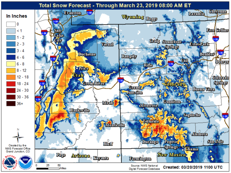
Forecast for the Moab Area Mountains

Eric Trenbeath
Issued by Eric Trenbeath for
Wednesday, March 20, 2019
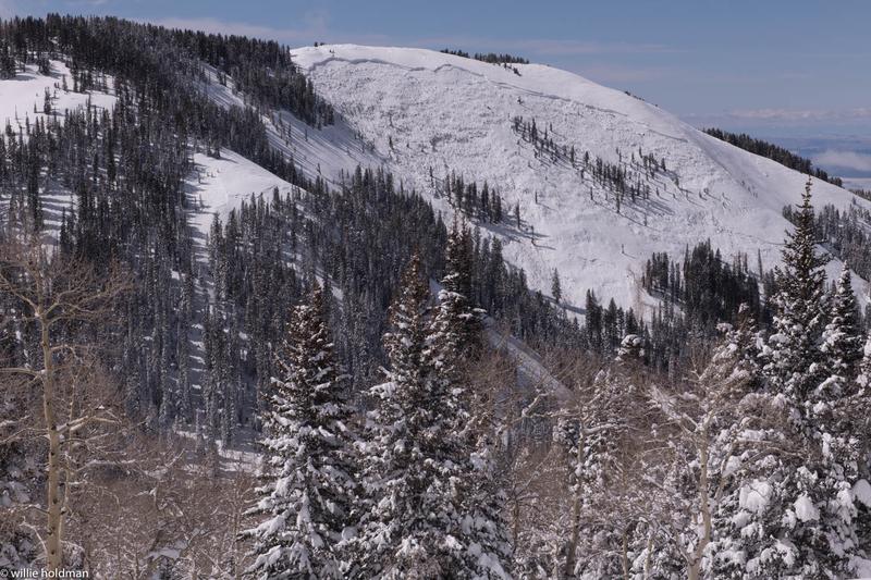
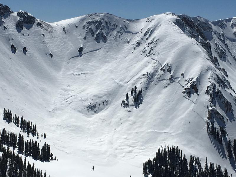
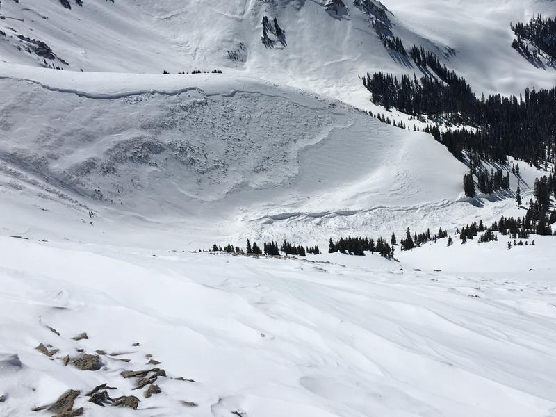
The avalanche danger is MODERATE today and deep and dangerous, human triggered avalanches, failing on a buried persistent weak layer are possible. Though the likelihood of triggering this type of avalanche has lessened, the consequences have not. Make no mistake, this type of avalanche is un-survivable. The problem exists primarily on steep slopes facing NW-N-E, but in some cases, it may be found on all aspects of the compass, particularly at upper elevations. And, as the day heats up, be alert to signs of wet instability on sun exposed slopes such as roller balls and pinwheels, and get off of steep, slopes as they become wet and sloppy.
Low
Moderate
Considerable
High
Extreme
Learn how to read the forecast here
Weather and Snow
Happy first day of Spring! And fittingly, today will be a beautiful day in the mountains before the lion roars back in tomorrow. Skies are clear, winds are light from the ENE, and temps are in the mid teens. Today will remain mostly sunny with perhaps a few high clouds streaming in ahead of an approaching storm system. Light, easterly winds will shift to the south by afternoon, and daytime highs will be in the mid 30's. Clouds will move into the area tonight, south winds will increase into the 20-25 mph range, with a chance for snow. But tomorrow is when the real actions starts. Expect strong south winds and up to a foot of snow possible during the day.
It's been a week since the last storm and concurrently, a major avalanche cycle. The strong March sun has affected the snow surface on all but the most sheltered, upper elevation, northerly aspects. All other surfaces are crusted over though I suspect some supportable, corn snow can be found on south facing slopes.
Here we go again!

New snow totals in Gold Basin (10,000')
Snotel totals at the Geyser Pass Trailhead (9600')
Winds at 11,000 feet on Abajo Peak (11,330') about 45 miles south.
National Weather Service point forecast.
Recent Avalanches
Following the storm on Tuesday/Wednesday there were many avalanches. Some broke within the new snow. However, many broke 1/4 to 1/2 mile wide at the ground. See the full list of avalanches we have cataloged so far HERE.
Below is a photo of a slope called Noriega's Face (photo W. Holdman)
Below is a photo of the Talking Mountain Cirque
Another slide in Gold Basin
Ad
Avalanche Problem #1
Persistent Weak Layer
Type
Location
Likelihood
Size
Description
Last week's storm produced a widespread avalanche cycle with slides breaking anywhere from 4'-12' deep on a persistent weak layer that has plagued us for much of the season. While we've experienced many active periods of natural activity since the new year began, this was the event that finally brought the house down. In total, 32" of snow with 3.6" of water weight was the straw that broke the proverbial camel's back. This was quite a thumping, and now, the big question is how long does it take for things to stabilize? Time and warm temperatures have certainly aided in the process. I would say at this point that triggering a deep and dangerous avalanche has become less likely. The problem is that signs of instability will not be presenting themselves and you may be able to put one, two, or several riders on a slope before someone finds the right trigger point. And if one is found, the avalanche will be deep, and un-survivable. The bottom line is that I'm not personally willing to take on that kind of risk.
Additional Information
Check out this clip of local Moab sledders playing it safe and making sure their beacons are on at the Geyser Pass Trailhead.
General Announcements
Your information can save lives. If you see anything we should know about, please help us out by submitting snow and avalanche observations HERE. You can also call me at 801-641-6307, or send me an email: [email protected].
Support the UAC through your daily shopping. When you shop at Smith's, or online at REI, Backcountry.com, Patagonia, NRS, Amazon, eBay by clicking on these links, they donate a portion of your purchase to the UAC. If you sell on eBay, you can have your See our Affiliate Page for more details on how you can support the UAC when you shop
This forecast is from the U.S.D.A. Forest Service, which is solely responsible for its content. This forecast describes general avalanche conditions and local variations always occur.