Forecast for the Moab Area Mountains

Mark Staples
Issued by Mark Staples for
Wednesday, March 13, 2019
Today heavy snowfall and strong west winds will make the avalanche danger HIGH on upper elevation, wind loaded slopes. All other terrain has a CONSIDERABLE danger.
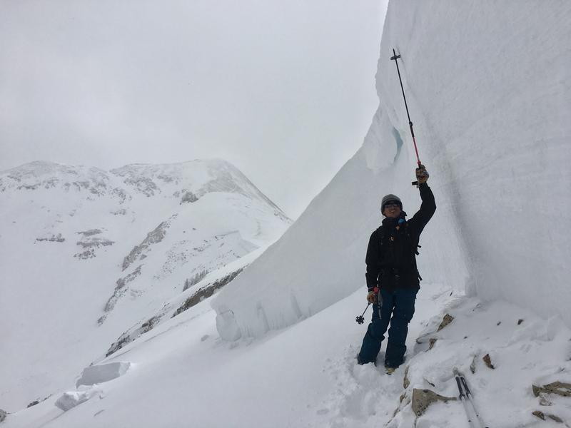
Smaller avalanches of wind drifted snow should be happening naturally today.
Avalanches may break much deeper in the snowpack on buried weak layers. These larger slides will be deadly and make for dangerous avalanche conditions. The best option is to avoid avalanche terrain today.
At all elevations and aspects, the new snow will continue accumulating today and should easily produce shallow avalanches.
Low
Moderate
Considerable
High
Extreme
Learn how to read the forecast here
Special Announcements
The road to Geyser Pass was last plowed Monday afternoon.
Weather and Snow
Yesterday temperatures warmed into the mid 30s F in Gold Basin and heavy wet snow was falling.
Overnight snowfall continued and temperatures started slowly dropping around midnight.
This morning as of 6 a.m. a total of 14 inches of heavy snow has accumulated (containing about 1.5 inches of water). Temperatures in Gold Basin are in the mid 20s F and probably in the upper teens at 11,000 feet. Winds this week have been blowing generally from the south but increased and began blowing from the west. I suspect most wind senors are rimed and reading lower wind speeds. West winds are probably averaging 20-30 mph and gusting 40 mph.
Today snowfall should continue with a foot of snow falling with about an inch of water. Temperatures should continue dropping and be in the upper teens by late afternoon. Strong winds should continue blowing from the west today.

New snow totals in Gold Basin (10,000')
Snotel totals at the Geyser Pass Trailhead (9600')
National Weather Service point forecast.
Recent Avalanches
On Saturday we found a massive natural avalanche on Pre-Laurel Peak that ran into Horse Creek. It was 6-12 feet deep and over 2500 feet wide and broke about 6 inches above the ground. See more pictures HERE and a video HERE. This slope had been loaded by strong SW winds on Thursday & Friday when it likely occurred.
Ad
Avalanche Problem #1
Wind Drifted Snow
Type
Location
Likelihood
Size
Description
Strong west winds and continued snowfall will form fresh slabs of wind drifted snow. Many of these wind slabs could be avalanching naturally today thus creating a HIGH avalanche danger. The ability of these smaller wind slabs to trigger avalanches breaking deeper in the snowpack will make the situation worse.
Avalanche Problem #2
Persistent Weak Layer
Type
Location
Likelihood
Size
Description
Avalanches breaking on buried persistent weak layers will be the most deadly. They can break deep in the snowpack and fracture over huge areas. The natural avalanche in Horse Creek at the end of last week is a good example. Today's rapid, heavy snowfall will stress these weak layers. Northerly facing slopes at mid and upper elevations have a weak layer near the ground. Upper elevation southerly slopes have a weak layer about 3-4 feet deep (video below).
Avoiding avalanche terrain is the only way to avoid this problem today.
Avalanche Problem #3
New Snow
Type
Location
Likelihood
Size
Description
Temperatures are dropping today which means the new snow will be right side up (light snow on top of heavy snow). It can be hard to know if the new snow will just sluff or break as a slab. Either way it will likely be easy to trigger a shallow avalanche that breaks within the new snow today especially during periods of heavy snowfall.
Additional Information
Check out this clip of local Moab sledders playing it safe and making sure their beacons are on at the Geyser Pass Trailhead.
General Announcements
Your information can save lives. If you see anything we should know about, please help us out by submitting snow and avalanche observations HERE. You can also call me at 801-641-630, or send me an email: [email protected].
Support the UAC through your daily shopping. When you shop at Smith's, or online at REI, Backcountry.com, Patagonia, NRS, Amazon, eBay by clicking on these links, they donate a portion of your purchase to the UAC. If you sell on eBay, you can have your See our Affiliate Page for more details on how you can support the UAC when you shop
This forecast is from the U.S.D.A. Forest Service, which is solely responsible for its content. This forecast describes general avalanche conditions and local variations always occur.