UDOT PLANNED AVALANCHE CLOSURES!!

Forecast for the Moab Area Mountains

Mark Staples
Issued by Mark Staples for
Monday, March 11, 2019
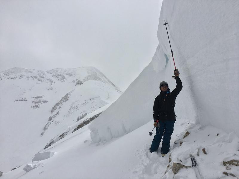
Today's conditions require careful snowpack evaluation and cautious route-finding. Triggering an avalanche may have gotten a just little harder to do today compared to yesterday, but there is still too much uncertainty and these are dangerous conditions. The most likely places to trigger a slide are mid and upper elevation slopes that were loaded by strong southerly winds where the avalanche danger is CONSIDERABLE.
Slopes without a load of wind drifted snow may still have weak layers lurking in the snowpack making human triggered avalanches possible. The avalanche danger on low elevation slopes and non wind loaded slopes is MODERATE.
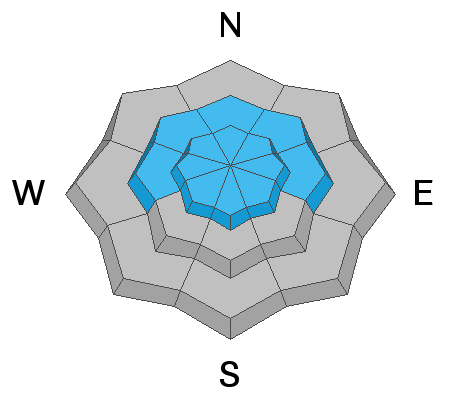
Low
Moderate
Considerable
High
Extreme
Learn how to read the forecast here
Special Announcements
Grand County will be plowing the road to Geyers Pass Trailhead THIS AFTERNOON! The road will be closed while plowing is in progress.
Pre-Laurel Peak is transmitting data again thanks to Ed Grote. Hopefully we'll have it posting online soon.
Weather and Snow
Yesterday an inch of snow accumulated in the morning and high temperatures ranged from the mid 30s to teens F.
This morning temperatures are 23 degrees F at Gold Basin and 28 degrees F at the Geyser Pass TH.
On Pre-Laurel Peak at 11,700 ft, the temperature is 16 degrees F and winds are averaging 16 mph gusting to 25 mph from the SSE.
Today cloudy skies should keep temperatures from rising much more than a few degrees. A few inches of snow should fall this morning. Heavier snowfall should arrive late tonight lasting through Wednesday when there could be a total of a foot of new snow. Winds will remain southerly today at similar speeds. It looks like very strong west winds may arrive on Wednesday.
New snow totals in Gold Basin (10,000')
Snotel totals at the Geyser Pass Trailhead (9600')
National Weather Service point forecast.
Recent Avalanches
On Saturday we found a massive natural avalanche on Pre-Laurel Peak that ran into Horse Creek. It was 6-12 feet deep and over 2500 feet wide and broke about 6 inches above the ground. See more pictures HERE. This slope had been loaded by strong SW winds on Thursday & Friday when it likely occurred. The 3 inches of water weight in the last seven days meant that this slope had been loaded by a total of 6 inches of water weight.
Ad
Avalanche Problem #1
Persistent Weak Layer
Type
Location
Likelihood
Size
Description
The snowpack has several weak, faceted layers of snow that can produce a deadly avalanche.
  1. Northerly facing slopes have weak, sugary snow near the ground. With such a deeply buried weak layer, triggering a large avalanche on it will be a little difficult but the consequences are huge.
  2. In isolated places there is a thin weak layer buried about a foot deep. Read more about this layer HERE. We couldn't find this layer in Gold Basin, but it's worth looking for since it's only about a foot deep.
  3. On Saturday, we confirmed what others have found on upper elevation S aspects. There is a weak layer of facets buried about 3 feet deep. See video below of our stability test at 11,600 feet on a S aspect.
What to do now? Basically we have to wait to ride avalanche terrain. The snowpack needs time to adjust to recently loading. Unfortunately it won't get a break with more snow coming this week and potentially strong winds in the middle of the week. Avoiding avalanche terrain is the main risk managment strategy, but this is hard to do in the La Sals.
Avalanche Problem #2
Wind Drifted Snow
Type
Location
Likelihood
Size
Description
Strong SW winds on Friday drifted snow even at low elevation and formed shallow soft slabs. These wind slabs are probably much less sensitive today compared to Friday. The main issue with wind slabs is they have added weight and stress to buried persistent weak layers. Triggering a recently formed wind slab is a good way to cause an avalanche that "steps down" to one of these weak layers.
Additional Information
Check out this clip of local Moab sledders playing it safe and making sure their beacons are on at the Geyser Pass Trailhead.
General Announcements
Your information can save lives. If you see anything we should know about, please help us out by submitting snow and avalanche observations HERE. You can also call me at 801-641-630, or send me an email: [email protected].
Support the UAC through your daily shopping. When you shop at Smith's, or online at REI, Backcountry.com, Patagonia, NRS, Amazon, eBay by clicking on these links, they donate a portion of your purchase to the UAC. If you sell on eBay, you can have your See our Affiliate Page for more details on how you can support the UAC when you shop
This forecast is from the U.S.D.A. Forest Service, which is solely responsible for its content. This forecast describes general avalanche conditions and local variations always occur.