Forecast for the Moab Area Mountains

Mark Staples
Issued by Mark Staples for
Sunday, March 10, 2019
The natural avalanche in Horse Creek is nature's way of screaming to us that other slopes are unstable as well. These are dangerous avalanche conditions that require careful snowpack evaluation and cautious route-finding which is the exact definition of today's danger rating. Today the avalanche danger is CONSIDERABLE on steep, wind drifted slopes. The danger is greatest on mid and upper elevation terrain that faces NW-N-SE, but at upper elevations, fresh drifts may be found on all aspects. In some areas, a triggered wind drift has the potential to step down into a buried persistent weak layer causing a deeper and more dangerous avalanche. The danger is MODERATE at low elevations and mid elevations without wind loading.
Low
Moderate
Considerable
High
Extreme
Learn how to read the forecast here
Special Announcements
UAC director Mark Staples will be issuing forecasts for the La Sal and Abajo Mountains while Eric takes a vacation to warmer climates and does a short stint in the SLC office.
We visited the weather station on Pre-Laurel Peak yesterday with Ed Grote. He helped us install new communication equipment. Hopefully that starts working and we'll have wind data from that location.
Weather and Snow
Yesterday started with temperatures in the single digits F but warmed into the 20's F and was a beautiful, cold winter day. Winds weren't moving much snow, but were blowing just enough at ridges to make it too cold to stand around very long. This morning temperatures at the Geyser Pass Trailhead are 26 deg F and at Gold Basin Study Plot 20 deg F. Looking at other weather stations further away and at weather models, my best guess for ridgetop winds at 11k is that they are blowing 10-15 mph from the SW with gusts of 30 mph.
Today temperatures should stay in the upper 20s F but may feel a bit warmer depending on how much sun appears. Winds should stay about what they are. As soon as you get off a ridgeline, you shouldn't feel much wind. The weather forecast calls for snow tonight and tomorrow. It looks like the best chance for more accumulating snow will be Monday evening. More snow should come through the week, but we'll see.
Recent snow has been very dense. Combined with cold temperatures, riding conditions are excellent. The snow surface is cold, dry, powdery, supportable, and fast for skiing on low angle slopes. There were a few snowflakes falling yesterday but the most recent snowfall was Friday afternoon and evening when 6 inches fell. Since last weekend, a total of 28 inches has fallen which contains 3 inches of water.
New snow totals in Gold Basin (10,000')
Snotel totals at the Geyser Pass Trailhead (9600')
National Weather Service point forecast.
Recent Avalanches
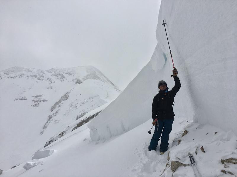
Yesterday we found a massive natural avalanche on Pre-Laurel Peak that ran into Horse Creek. It was 6-12 feet deep and over 2500 feet wide and broke about 6 inches above the ground. See more pictures HERE. This slope had been loaded by strong SW winds on Thursday & Friday when it likely occurred. The 3 inches of water weight in the last seven days meant that this slope had been loaded by a total of 6 inches of water weight.
Ad
Avalanche Problem #1
Persistent Weak Layer
Type
Location
Likelihood
Size
Description
The snowpack has several weak, faceted layers of snow that can produce a deadly avalanche:
  1. The large avalanche we spotted yesterday is a major red flag that other slopes are unstable and could produce similarly massive avalanches. That avalanche occurred on a NW facing slope at about 11,600 feet. Triggering one at the ground would be most likely on a slope loaded by recent strong southerly winds.
  2. Two days ago we found a faceted layer about a foot deep at 10,000 feet on a sheltered NW facing slope. We couldn't find it yesterday in Gold Basin. This layer produced a loud collapse and we felt the slope drop a little which is the same as triggering an avalanche but we were on a low angle slope so the snow didn't slide. See our stability test on this layer HERE.
  3. Yesterday we confirmed what others have found on S aspects. There is a weak layer of facets on these aspects as well. The one we found was about 3 feet deep. See our stability test on this layer HERE.
What to do now? Basically we have to wait. Avoiding avalanche terrain is the main risk mitigation strategy. The snowpack needs time to adjust to recent loading. How much time? It's hard to say. The good new is that more snow is coming. The bad news is that with more snow coming, they snowpack will get stressed again and we'll have to wait more.
Avalanche Problem #2
Wind Drifted Snow
Type
Location
Likelihood
Size
Description
Recent strong SW winds easily transported Friday's 6 inches of new snow. Fresh slabs of wind drifted snow should start stabilizing today to various degrees. There are several layers of soft and hard snow and a mix of rain and rime crusts on which these wind slabs can break. The easiest way to deal with fresh wind slabs today will be to avoid them.
There's another reason to avoid fresh wind slabs today - there's a really good chance that an avalanche involving a wind slab will step down and produce a much larger avalanche breaking on a buried persistent weak layer. Even if the wind slabs begin stabilizing, the weight (and stress) they put on these buried layers doesn't go away.
Additional Information
Check out this clip of local Moab sledders playing it safe and making sure their beacons are on at the Geyser Pass Trailhead.
General Announcements
Your information can save lives. If you see anything we should know about, please help us out by submitting snow and avalanche observations HERE. You can also call me at 801-641-630, or send me an email: [email protected].
Support the UAC through your daily shopping. When you shop at Smith's, or online at REI, Backcountry.com, Patagonia, NRS, Amazon, eBay by clicking on these links, they donate a portion of your purchase to the UAC. If you sell on eBay, you can have your See our Affiliate Page for more details on how you can support the UAC when you shop
This advisory is from the U.S.D.A. Forest Service, which is solely responsible for its content. This advisory describes general avalanche conditions and local variations always occur.