UDOT PLANNED AVALANCHE CLOSURES!!

Forecast for the Moab Area Mountains

Eric Trenbeath
Issued by Eric Trenbeath for
Saturday, March 9, 2019
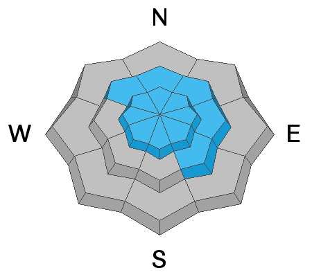
The avalanche danger is CONSIDERABLE today and human triggered avalanches are likely on steep, wind drifted slopes. The danger is greatest on mid and upper elevation terrain that faces NW-N-SE, but at upper elevations, fresh drifts may be found on all aspects. In some areas, a triggered wind drift has the potential to step down into a buried persistent weak layer causing a deeper and more dangerous avalanche. Careful snow stability analysis is required, and any wind drifted slope much steeper than about 30 degrees should be avoided.
Low
Moderate
Considerable
High
Extreme
Learn how to read the forecast here
Special Announcements
UAC director Mark Staples will be issuing forecasts for the La Sal and Abajo Mountains while I take a vacation to warmer climes. After that I'll be pulling a short stint in the SLC office. I want to thank Mark for coming donw, and the local community for showing him around.
Weather and Snow
The mountains picked up another 6" of snow yesterday afternoon and evening for a total of 28", and more than 3" of water since last Sunday. Strong SW winds blew most of the day yesterday. They made a shift to the WNW in the afternoon and continued to blow in the 20-30 mph range. They backed off around 4:00 a.m. this morning and are relatively calm averaging 10-15 mph. Temps are the coldest they've been in more than a week coming in at 15 degrees at the Geyser Pass Trailhead, and a mere 6 degrees at the Gold Basin Study Plot. Today look for sunny skies this morning with clouds moving in later today. SW winds will be light to moderate along ridge tops and high temps will be in the low 20's. Next chance for snow looks like Mon into Tue.
Though we haven't had a major dump, dense snow has been stacking up throughout the week, and fast and creamy turning and riding conditions abound in sheltered locations. Strong winds have affected exposed surfaces, and there is a rain/rime crust below about 10,000. UAC director Mark Staples joined us yesterday and sent in this observation.
New snow totals in Gold Basin (10,000')
Snotel totals at the Geyser Pass Trailhead (9600') y
Wind, temperature, and humidity on Pre Laurel Peak (11,700')
National Weather Service point forecast.
Ad
Avalanche Problem #1
Wind Drifted Snow
Type
Location
Likelihood
Size
Description
Strong SW winds yesterday blew and drifted snow onto the leeward sides of ridge crests and terrain features at mid and upper elevations. The deepest drifts will be found on slopes facing NW-N-E, but a shift in in wind direction later in the day has deposited snow on to southerly aspects. You can recognize wind drifted slopes by their smooth, rounded, or "fat" appearance, and any steep, wind loaded slope should be avoided today. In some areas, the recent drifts are overlying a persistent weak layer creating the potential for a deeper, and more dangerous avalanche. More on this below.
Avalanche Problem #2
Persistent Weak Layer
Type
Location
Likelihood
Size
Description
In our travels yesterday we found a reactive persistent weak layer of buried facets underneath this week's accumulated snow. We found this layer on a NW aspect around 10,000', and though we aren't sure how widespread it is, this is something you are going to want to look out for. A quick snowpit will tell you if it's there. Digging deeper, we found a generally strong snowpack, but in areas where the pack is shallower, it may still be possible to trigger an avalanche on a buried persistent weak layer. Most likely areas are steep, rocky, and sparsely treed northerly aspects. Slopes that have previously avalanched or that have been wind scoured and filled back in are also suspect.
It's easy to see the newest persistent weak layer in an exposed pit wall.
Extended column tests produced full propagation on 4, 12, and 14 taps.
Additional Information
Check out this clip of local Moab sledders playing it safe and making sure their beacons are on at the Geyser Pass Trailhead.
General Announcements
Your information can save lives. If you see anything we should know about, please help us out by submitting snow and avalanche observations HERE. You can also call me at 801-647-8896, or send me an email: [email protected].
Support the UAC through your daily shopping. When you shop at Smith's, or online at REI, Backcountry.com, Patagonia, NRS, Amazon, eBay by clicking on these links, they donate a portion of your purchase to the UAC. If you sell on eBay, you can have your See our Affiliate Page for more details on how you can support the UAC when you shop
This advisory is from the U.S.D.A. Forest Service, which is solely responsible for its content. This advisory describes general avalanche conditions and local variations always occur.