Forecast for the Moab Area Mountains

Issued by Eric Trenbeath on
Friday morning, March 8, 2019
Friday morning, March 8, 2019
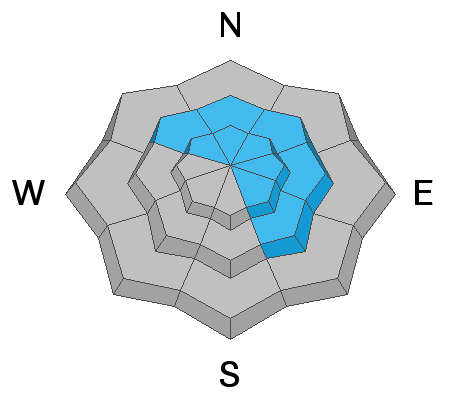
The avalanche danger is generally MODERATE this morning but could rise to CONSIDERABLE later today as new snow and wind create fresh drifts along upper elevation ridge crests and terrain features, primarily on slopes that face NW-N-SE. New wind drifts will cover old, and avalanches up to 3' deep will be possible on steep, wind loaded terrain. Be alert to changing conditions and adjust your plans accordingly. There also remains an isolated or MODERATE danger for triggering a deep and dangerous avalanche on a buried, persistent weak layer. You are most likely to encounter this problem on steep, rocky, northerly facing slopes, or in areas with a shallower snowpack.

Low
Moderate
Considerable
High
Extreme
Learn how to read the forecast here