Forecast for the Moab Area Mountains

Eric Trenbeath
Issued by Eric Trenbeath for
Wednesday, February 20, 2019
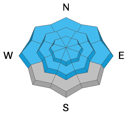
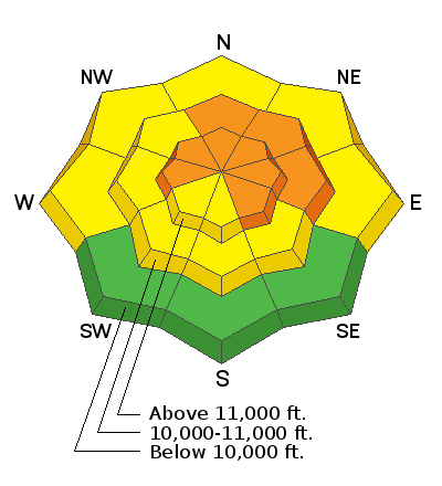
In the wind zone, areas of CONSIDERABLE avalanche danger still exist on steep, wind drifted slopes that face W-N-SE. Most other terrain has a MODERATE danger for avalanches involving wind drifted snow, and buried persistent weak layers. Continue to avoid, steep, wind drifted slopes, especially those facing the north half of the compass. The danger is expected to rise overnight and could reach HIGH by tomorrow.
Low
Moderate
Considerable
High
Extreme
Learn how to read the forecast here
Avalanche Watch
THE FOREST SERVICE UTAH AVALANCHE CENTER IN MOAB HAS ISSUED A BACKCOUNTRY AVALANCHE WATCH.
* TIMING…IN EFFECT FROM 6 AM MST THIS MORNING TO 6 AM MST THURSDAY
* AFFECTED AREA…FOR THE LA SAL AND ABAJO MOUNTAINS OF SOUTHEASTERN UTAH
* AVALANCHE DANGER…THE AVALANCHE DANGER FOR THE WATCH AREA IS EXPECTED TO RISE TO HIGH.
* IMPACTS…STRONG WINDS WITH PERIODS OF HEAVY SNOW WILL CREATE WIDESPREAD AREAS OF UNSTABLE SNOW. THE AVALANCHE DANGER WILL REMAIN ELEVATED THROUGH THE WEEKEND WITH BOTH HUMAN TRIGGERED AND NATURAL AVALANCHES BECOMING LIKELY. TRAVEL IN AVALANCHE TERRAIN IS NOT RECOMMENDED. STAY OFF OF AND OUT FROM UNDER SLOPES STEEPER THAN 30 DEGREES.
BACKCOUNTRY TRAVELERS SHOULD CONSULT WWW.UTAHAVALANCHECENTER.ORG OR CALL 1-888-999-4019 FOR MORE DETAILED INFORMATION.
Special Announcements
Grand County will not be plowing until after the coming storm. Many vehicles have been making it up. Expect to find 3"-5" of snow with ruts. 4x4 required.
The latest UAC Podcast was just released: The Message and the Messengers - A Conversation with Alex Hamlin. In this podcast forecaster Drew Hardesty sits down with Alex Hamlin. For over fifteen years, Alex Hamlin has worked at the intersection of storytelling and outdoor sport, with experience at magazines, global retail brands and creative agencies. In the conversation, they talk about the psychology behind marketing (and influencing behavior change), with a particular eye toward marketing safety.
I was fortunate enough to get out and ride with some of the local talent on Sunday. With a danger rating of CONSIDERABLE, we stuck to low angle terrain and and found lots of deep snow to play in. Everyone carried proper rescue gear and it was cool to see them use our new beacon checker sign at the trailhead.
Weather and Snow
The story today is the cold! It's currently -4 at the Geyser Pass Trailhead and -10 in Gold Basin. Westerly ridge top winds are averaging 15-20 mph. Today look for mostly cloudy skies ahead of the next powerful storm system that will begin to affect our area this evening. We may see a few scattered snow showers this afternoon but the real action won't start until tonight. Winds will shift to the SW later today but will remain in the moderate range. High temps will creep up to around 10 degrees.
Folks yesterday continue to report excellent conditions below treeline. Chris Jacobsen found very deep snow for sledding around on the east side of the range, and Dave Garcia said skiing remains quite good in sheltered areas. Read his observation here. Above treeline, the snow surface has sustained some wind damage.

New snow totals in Gold Basin (10,000')
Snow totals at the Geyser Pass Trailhead (9600')
Wind, temperature, and humidity on Pre Laurel Peak (11,700')
National Weather Service point forecast.
Looks like a Southern Utah Special!
Recent Avalanches
I received a report of a snowmobile triggered avalanche yesterday. The rider was traveling along a ridge when the slide released below him. I don't know if it was a wind slab if it failed on a persistent weak layer. I'm going to go have a look today.
Natural avalanche activity from last week's storm cycle appears to be mainly isolated wind slabs within the most recent snow. The deepest slide I saw came out of a steep, rocky, north facing pocket at around 11,000' just east of Colorado Bowl. I saw it from a distance, but it looked deep enough to have involved a persistent weak layer.
Ad
Avalanche Problem #1
Wind Drifted Snow
Type
Location
Likelihood
Size
Description
Wind drifted snow continues to be our primary concern though most wind slabs are now several days old. The deepest drifts have formed along upper elevation ridge crests on slopes that face NW-N-SE, but they also exist in open areas below treeline. Continue to avoid steep, wind drifted slopes. They are often recognizable by their smooth, rounded appearance.
Avalanche Problem #2
Persistent Weak Layer
Type
Location
Likelihood
Size
Description
The snow load from last week was a pretty good test for the snowpack, and the lack of natural activity involving persistent weak layers indicates that the pack is gaining strength. However, the overall snowpack structure remains poor, and weak layers now exist on all aspects. Pro observer Travis Nauman turned back from an upper elevation SE facing slope after his ECT produced propagation on several interfaces. See his observation for more details. The bottom line is you will have to do a slope by slope analysis before considering terrain steeper than 35 degrees.
General Announcements
Your information can save lives. If you see anything we should know about, please help us out by submitting snow and avalanche observations HERE. You can also call me at 801-647-8896, or send me an email: [email protected].
Support the UAC through your daily shopping. When you shop at Smith's, or online at REI, Backcountry.com, Patagonia, NRS, Amazon, eBay by clicking on these links, they donate a portion of your purchase to the UAC. If you sell on eBay, you can have your See our Affiliate Page for more details on how you can support the UAC when you shop
This advisory is from the U.S.D.A. Forest Service, which is solely responsible for its content. This advisory describes general avalanche conditions and local variations always occur.