Forecast for the Moab Area Mountains

Eric Trenbeath
Issued by Eric Trenbeath for
Thursday, February 21, 2019
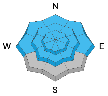
Today will be a day of rising avalanche danger. The avalanche danger is CONSIDERABLE but could reach HIGH by the end of the day on steep, upper elevation slopes that face NW-N-E. The rise in danger will directly correlate to new snow amounts, and backcountry travelers today will need to pay attention to changing conditions. Conservative decision making is essential. Stay off of and out from under steep, avalanche prone terrain.
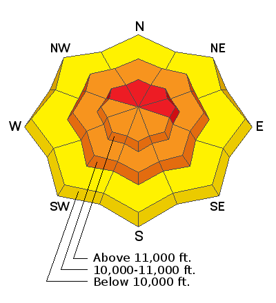
Low
Moderate
Considerable
High
Extreme
Learn how to read the forecast here
Special Announcements
I've issued an Avalanche Warning for the Abajo Mountains.
Grand County will not be plowing until after the storm. Many vehicles have made it up this week but the road will become more challenging as the day progresses. 4x4 required.
Weather and Snow
About 4" of snow has accumulated since yesterday afternoon. SE winds are blowing 15-20 mph along ridge tops, and 10,000' temps are in the single digits. The current storm system is tracking slightly south favoring mountainous areas near the Four Corners. Camp Jackson in the Abajos is reporting a foot of snow overnight. Up here in the La Sals, we'll see snow throughout the day with what looks like about an additional 6" by tonight. SE winds will continue to be pretty well behaved averaging 15-20 mph with gusts to 30. Daytime high temps will be in the mid teens. Snow should continue overnight and into Friday.
Conditions were already good, and they'll only be better today. Keep it safe however, and stick to low angle, wind sheltered terrain. Tim Mathews was up yesterday and sent in this observation.

New snow totals in Gold Basin (10,000')
Snow totals at the Geyser Pass Trailhead (9600')
Wind, temperature, and humidity on Pre Laurel Peak (11,700')
National Weather Service point forecast.
Looks like a Southern Utah Special!
Recent Avalanches
Most natural avalanches from the last storm cycle were confined to the most recent snow. On Tuesday, Feb 19 however, a party of snowmobilers remotely triggered an avalanche from a ridge top. The slab failed on the December persistent weak layer. Details here.
Ad
Avalanche Problem #1
New Snow
Type
Location
Likelihood
Size
Description
We will likely start to see avalanche problems within the new snow as the day progresses and accumulations increase. This problem may appear as sensitive soft slabs, or loose snow sluffing. The biggest concern will be natural activity from above where gathering snow will pack quite a punch. Stay out from under steep, high faces, especially those with a northerly aspect.
Avalanche Problem #2
Wind Drifted Snow
Type
Location
Likelihood
Size
Description
Wind drifted snow will from sensitive soft slabs today, primarily in upper elevation terrain that faces the north half of the compass. Be on the lookout for fresh drifts on the lee sides of ridge crests and terrain features. In addition, new drifts will cover older wind slabs that have formed over the course of the past week. Most of the older slabs are now pretty welded into place, but I would still remain skeptical of any fat looking slope that has a smooth rounded appearance.
Avalanche Problem #3
Persistent Weak Layer
Type
Location
Likelihood
Size
Description
Poor snowpack structure continues to plague the snowpack and persistent weak layers remain a concern. As the snowpack gains strength the problem is becoming less widespread, but Tuesday's remotely triggered avalanche is a stark reminder of how real the problem can be. The most likely areas of concern are steep, rocky, northerly facing aspects right around treeline, and in areas where the snowpack is shallow and weak. Avalanche paths that have already run are also suspect. Bottom line is that neither I, nor any of the local observers are ready to push it into any steep, northerly facing terrain.
Additional Information
Check out this clip of local Moab sledders playing it safe and making sure their beacons are on at the Geyser Pass Trailhead.
General Announcements
Your information can save lives. If you see anything we should know about, please help us out by submitting snow and avalanche observations HERE. You can also call me at 801-647-8896, or send me an email: [email protected].
Support the UAC through your daily shopping. When you shop at Smith's, or online at REI, Backcountry.com, Patagonia, NRS, Amazon, eBay by clicking on these links, they donate a portion of your purchase to the UAC. If you sell on eBay, you can have your See our Affiliate Page for more details on how you can support the UAC when you shop
This advisory is from the U.S.D.A. Forest Service, which is solely responsible for its content. This advisory describes general avalanche conditions and local variations always occur.