Observation: Moab

Observation Date
2/17/2019
Observer Name
Nauman, Bolos, Quinn
Region
Moab
Location Name or Route
Goldminers
Weather
Sky
Broken
Precipitation
Moderate Snowfall
Wind Direction
Southeast
Wind Speed
Moderate
Weather Comments
The day started pretty sunny with some cool orographically driven flurries, and very little wind. This was exciting as the wind has been so crazy the last few weeks. We were hoping to get up into the alpine to test out southern faces. However, when we arrived at PreLaurel Peak weather station, the weather started to turn. The wind kicked up and snow showers became more frequent and intense. By the time we finished digging a rather quick snowpit, the wind was starting to rage with considerable snow transport. Unfortunately, we seem to be trapped in a cycle where each storm brings it's fury via wind, and we've had storms with varying dominant wind direction which has created a rather chaotic distribution of wind alterations of the snow.
Snow Characteristics
New Snow Depth
1"
New Snow Density
Low
Snow Surface Conditions
Powder
Dense Loose
Wind Crust
Snow Characteristics Comments
There is still plenty of soft snow about in areas sheltered from the wind. Punchy areas where the prior wet snow breaks also exist. The top of the north woods had about 1" of new snow around 2pm.
Red Flags
Red Flags
Recent Avalanches
Wind Loading
Poor Snowpack Structure
Red Flags Comments
There have been several recent small wind slab avalanches in upper Talking Mountain Cirque (NW), Tukno (NE), and Dory Canyon (N) in areas that have been heavily loaded by wind transport. I did a quick (terribly cold wind) snowpit today to evaluate Goldminers and found some interesting stuff. Firstly, it was awesome to find 160 cm of snow on a SSE aspect at 11,500 feet! We had failures in our single ECT test at the following layers 1) ECTP11 @ 115cm (~resistant planar) with a very smooth Q1 shear surface at the bottom of the last wet snow cycle, 2) Then on the 13th hit before clearing the slab off of the 115 cm break, we had an ECTP 13 @ 98 cm with a sudden planar Q1 shear that popped out like an inch on 1.5 mm facets under an old suncrust - not good... and 3) finally, after pulling off the 98 cm slab, I gorilla slapped (2 handed full body slap!) the remaining column and got a sudden collapse failure in the December facets. These results sent us skinning back up onto the windy Laurel Ridgeline back to the North Woods refuge. Unfortunately, this result adding to the large 2'-3' avalanche we had on lower Show-Off over to lower Funnel (SW aspects) a few weeks back are indicating persistent weak layers even on the south faces.
Avalanche Problem #1
Problem
Wind Drifted Snow
Trend
Increasing Danger
Problem #1 Comments
There are lots of wind slabs out there and this storm seems like it will add to the problem.
Avalanche Problem #2
Problem
Persistent Weak Layer
Trend
Same
Problem #2 Comments
Facets under a snow crust and basal facets are both persistent weak layers in south facing mid to upper elevation slopes. I would also add in a 'new snow' concern from the last storm, which did produce a ECTP11 under a 45 cm slab, which is nothing to scoff at.
Comments
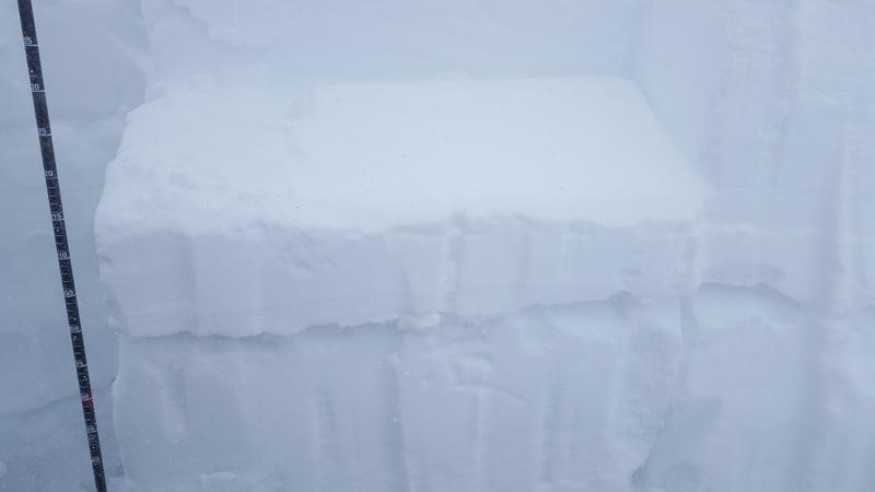
The shear surface at the new snow interface from our storm that ended yesterday. You can also see the facets under the suncrust @ 98cm.
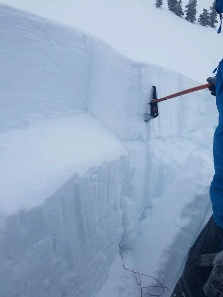
Here is the shear surface at 98 cm where we had the sudden planar failure. Definitely not something I want to be on top of.
Today's Observed Danger Rating
Considerable
Tomorrows Estimated Danger Rating
Considerable
Coordinates