Forecast for the Moab Area Mountains

Eric Trenbeath
Issued by Eric Trenbeath for
Saturday, February 17, 2024
The avalanche danger is MODERATE. Deep, dangerous, and potentially deadly avalanches 3-6 feet deep, failing on a buried persistent weak layer remain possible on steep slopes that face W-N-E-SE with the greatest danger existing on slopes facing NW-N-E. Although the odds of triggering a slide have dropped, the consequences remain the same.
A MODERATE danger for human triggered avalanches involving shallow slabs of wind drifted snow exists on all aspects above treeline. Fresh drifts generally have a smooth rounded appearance and cracking is a sign of instability.

A generally LOW danger exists on slopes facing S-SW.
Low
Moderate
Considerable
High
Extreme
Learn how to read the forecast here
Special Announcements
Dave Garcia and I will be hanging out at the Geyser Pass Winter Trailhead this morning to answer any questions or to just say hi as part of our statewide Trailhead Avalanche Awareness Program.
We are seeking a passionate individual to join us as Executive Director of the nonprofit Utah Avalanche Center. Click here for more information.
Road Conditions: The Geyser Pass Road is plowed but snowpacked and slick!
Grooming: Gold Basin was groomed with classic track yesterday.
Weather and Snow
6:00 a.m. Snow and Weather Data
24 Hour Snow 0" 72 Hour Snow T" Season Total Snow 131" Depth at Gold Basin 50"
Winds on Pre-Laurel Peak: NW 15-20 Temp 10° Percent of Normal: 105%

Weather
Ridgetop winds from the NW were on the increase overnight as a storm to the north moved eastward. They should back off today and we can expect sunny skies and high temps in the upper 20's at 10,000'. Sunday will be mostly cloudy with a chance for showers. Monday again looks sunny before an unsettled weather pattern moves in on Tuesday.
General Conditions
It's been a week now since the last significant snow fell, and with several days of strong sun and some wind, you're going to have to work harder to find soft snow. Seek out sheltered, northerly facing terrain for the safest and best turning and riding conditions. Shifiting winds over the last couple of days have transported snow and built some shallow stiff slabs along the leeward sides of ridge crests and terrain features in upper elevation, wind exposed terrain. Our primary concern however, remains the persistent weak layer of faceted snow that's buried between 2'-4' deep. Although the likelihood is decreasing, deep and dangerous avalanches failing on this layer are still possible on slopes facing W-N-E-SE, with the greatest likelihood existing on steep, wind loaded, northerly facing terrain. Over in Colorado, where they have a similar snowpack, people are triggering avalanches daily down to this weak layer, sometimes after multiple runs on the same slope. Likely trigger points include thinner snowpack areas along slope margins, near rocky outcrops, or in areas of steep, rocky, radical terrain.
Sam Van Wetter was out yesterday and he found good snow in sheltered terrain but noted that the surface was weakening. See his observation here. I spent my time yeserday checking out persistent weak layer concerns below treeline. See my full report here.
Snowpack and Weather Data
Gold Basin Storm Stake (10,000')
Gold Basin SNOTEL site (10,000')
SNOTEL site near Geyser Pass Winter Trailhead (9600')
Wind Station on Pre-Laurel Peak (11,400')
NWS forecast for the La Sal Mountains.
Ad
Avalanche Problem #1
Persistent Weak Layer
Type
Location
Likelihood
Size
Description
It's no secret that we have a persistent weak layer of faceted snow at the base of the snowpack on W-N-E-SE aspects, and that this layer produced numerous deep avalanches during the stormy period between Feb 2-8. As the dust settles so to speak, human triggered avalanches failing on this weak layer are becoming less likely but the reuslts remain potentially deadly. In my travels yesterday I dug at lower elevations where the snowpack is shallow and continued to have reactive stability tests. Low elevations aren't the only places with a shallow snowpack and these are the areas where you are most likely to trigger an avalanche. You really need to do your homework before commiting to anytning steep. Dig, probe, avoid areas that are less than about 180-200 cms deep. Avoid steep, rocky areas, slope margins, thin convexities. These are all likely trigger points.
Here's how Dave is handling the current situation:
"I am continuing to evaluate the snow and terrain carefully. I am slowly biting off pieces of terrain. Nibbling at the edges before I go all in. I am probing the snowpack to be sure that I am skiing in areas with deep snow. I am ok with some overhead hazard, but I am generally keeping my slope angles low. I am choosing terrain that has gradual transitions and I am avoiding complex terrain with terrain traps and cliff bands. Remember that during moderate danger with a PWL, deep and dangerous human-triggered avalanches remain possible."
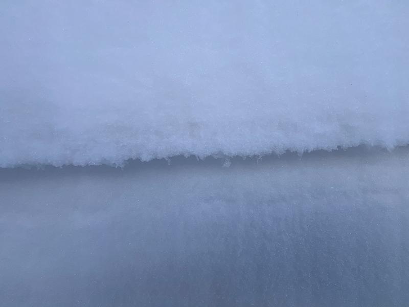
In the snowpit below, dug on a NE aspect at 10,000', I also found a reactive layer of surface hoar. I don't think this problem is widespread but it tells me that our snowpack is anything but cut and dried right now. We have basal facets, we have areas with mid and upper pack weak layers, but we lack outward signs of instability. This can give us a false sense of security, but it's not time to let our guard down.
Clearly defined layer of surface hoar.
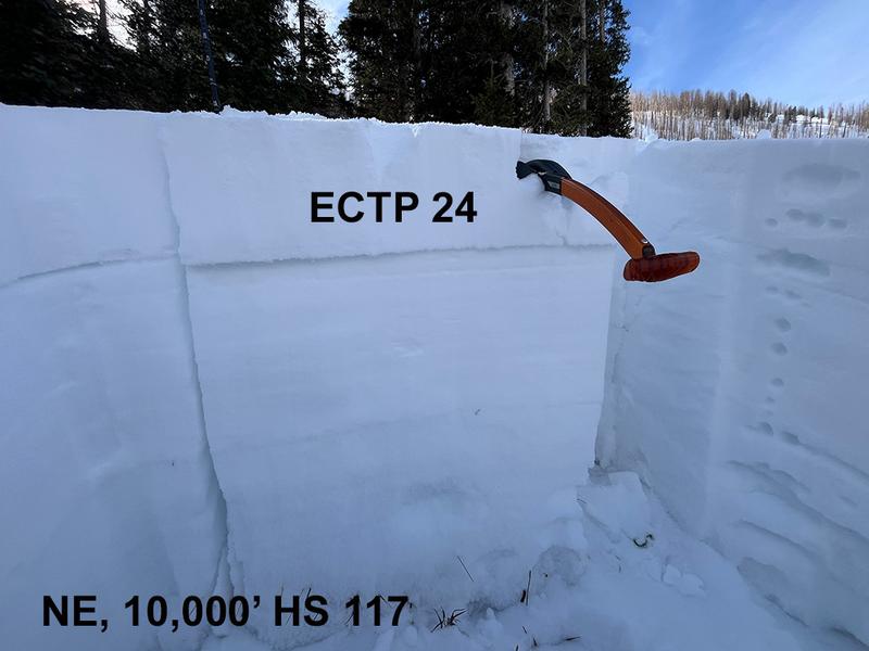
Total snow depth or height of snow (HS) is 117 cms. Extended column test results of ECTP 24.
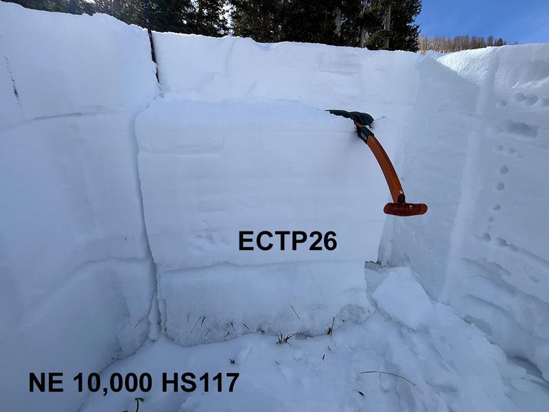
Extended column test results of ECTP26 failing on the basal facets. This is somewhat stubborn but it illustrates that deep avalanches remain possible, especially in shallow snowpack areas.
Avalanche Problem #2
Wind Drifted Snow
Type
Location
Likelihood
Size
Description
Shifting winds over the past few days have built shallow slabs on all aspects above treeline. Fresh drifts generally have a smooth rounded appearance and cracking is a sign of instability. Avoid steep slopes that have fresh deposits of wind drifted snow. On steep northerly aspects, a triggered wind slab could step down into the buried persistent weak layer causing a deeper and more dangerous avalanche.
Additional Information
Want some more insight into the La Sal Mountains as well as the communal impacts of a tragic avalanche? Check out the latest UAC podcast with forecaster Eric Trenbeath where he discusses the range, it's often treacherous snowpack, and how the devastating avalanche in February, 1992, affected the Moab community.
Our avalanche beacon checker sign and beacon training park are up and running. A huge thanks to Talking Mountain Yurts for sponsoring those this season!
Sign up for forecast region-specific text message alerts. You will receive messages about changing avalanche conditions, watches, warnings and road plowing closures.
Follow us on Instagram @utavy_moab
General Announcements
This forecast is from the U.S.D.A. Forest Service, which is solely responsible for its content. This forecast describes general avalanche conditions and local variations always occur.