Forecast for the Moab Area Mountains

Eric Trenbeath
Issued by Eric Trenbeath for
Friday, February 16, 2024
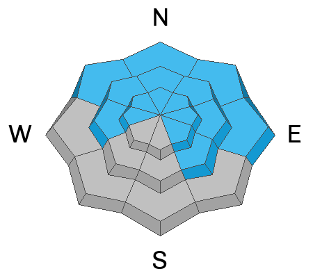
The avalanche danger is MODERATE. Deep, dangerous, and potentially deadly avalanches 3-6 feet deep, failing on a buried persistent weak layer remain possible on steep slopes that face W-N-E-SE with the greatest danger existing on slopes facing NW-N-E. And although the odds of triggering a slide have dropped, the consequences remain the same.
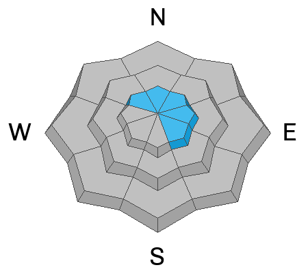
Winds from the south and west over the past few days have built shallow, stiff slabs of wind-drifted snow on leeward facing slopes above treeline. Look for signs of instability such as cracking in the snow surface and avoid areas that sound or feel hollow underneath.
A LOW danger exists on slopes facing S-SW.
Low
Moderate
Considerable
High
Extreme
Learn how to read the forecast here
Special Announcements
Monday, February 12 marked the 31st anniversary of the tragic Talking Mountain Cirque avalanche accident where six backcountry skiers were buried, and four, including the La Sal avalanche forecaster, were killed. The town of Moab was devastated, and the impacts are still felt today. It is worth your time to Read the report here.
We are seeking a passionate individual to join us as Executive Director of the nonprofit Utah Avalanche Center. Click here for more information.
Road Conditions: The Geyser Pass Road is plowed.
Grooming: LUNA will be freshening up trails today.
Weather and Snow
6:00 a.m. Snow and Weather Data
24 Hour Snow 0" 72 Hour Snow 0" Season Total Snow 131" Depth at Gold Basin 50"
Winds on Pre-Laurel Peak: WNW 5-10 Temp 17° Percent of Normal: 105%

Weather
Quiet weather continues for our zone and we can look forward to mostly sunny skies, light to moderate westerly winds, and high temps near 30 today. Expect similar conditions tomorrow.
A passing shortwave will bring clouds and slight chance of snow on Sunday. A period of unsettled weather begins early next week but I'm not seeing anything significant yet. We'll have to wait a few days to see how things evolve.
General Conditions
It's been a week now since the last significant snow fell, and with several days of strong sun and some wind, you're going to have to work harder to find soft snow. Seek out sheltered, northerly facing terrain for the safest and best turning and riding conditions. Winds from the south and west over the last couple of days have transported snow and built some shallow stiff slabs along the leeward sides of ridge crests and terrain features in upper elevation, wind exposed terrain. Our primary concern however, remains the persistent weak layer of faceted snow that's buried between 2'-4' deep. Although the likelihood is decreasing, deep and dangerous avalanches failing on this layer are still possible on slopes facing W-N-E-SE, with the greatest likelihood existing on steep, wind loaded, northerly facing terrain. Over in Colorado, where they have a similar snowpack, people are triggering avalanches daily down to this weak layer, sometimes after multiple runs on the same slope. Likely trigger points include thinner snowpack areas along slope margins, near rocky outcrops, or in areas of steep, rocky, radical terrain.
Snowpack and Weather Data
Gold Basin Storm Stake (10,000')
Gold Basin SNOTEL site (10,000')
SNOTEL site near Geyser Pass Winter Trailhead (9600')
Wind Station on Pre-Laurel Peak (11,400')
NWS forecast for the La Sal Mountains.
Ad
Avalanche Problem #1
Persistent Weak Layer
Type
Location
Likelihood
Size
Description
Persistent weak layers that formed in November and December produced numerous deep and dangerous avalanches going back to February 2. These avalanches ran during a period of high danger. Most avalanche accidents happen after the natural cycle is over, when the danger is dropping down to considerable, and eventually moderate. The natural activity may be over, but many slopes hang in the balance just waiting for a skier or rider to come along and trigger deep, dangerous, and deadly avalanches. The danger is most pronounced in areas with a shallow snowpack. Steep rocky terrain, and slopes that typically get wind-scoured are likely places to trigger an avalanche. Areas that have previously avalanched are also suspect.
Here's how Dave is handling the current situation:
"I am continuing to evaluate the snow and terrain carefully. I am slowly biting off pieces of terrain. Nibbling at the edges before I go all in. I am probing the snowpack to be sure that I am skiing in areas with deep snow. I am ok with some overhead hazard, but I am generally keeping my slope angles low. I am choosing terrain that has gradual transitions and I am avoiding complex terrain with terrain traps and cliff bands. Remember that during moderate danger with a PWL, deep and dangerous human-triggered avalanches remain possible."
Avalanche Problem #2
Wind Drifted Snow
Type
Location
Likelihood
Size
Description
Winds from the west and south have built stiff, shallow slabs of wind drifted snow on northerly aspects. In and of themselves, they shouldn't be too problematic, the real problem is where they are developing - on steep northerly aspects above treeline, or the same areas where you are most likely to trigger a deep avalanche failing on a buried persistent weak layer. Personally, I'm just going to continue to avoid this terrain.
Additional Information
Want some more insight into the La Sal Mountains as well as the communal impacts of a tragic avalanche? Check out the latest UAC podcast with forecaster Eric Trenbeath where he discusses the range, it's often treacherous snowpack, and how the devastating avalanche in February, 1992, affected the Moab community.
Our avalanche beacon checker sign and beacon training park are up and running. A huge thanks to Talking Mountain Yurts for sponsoring those this season!
Sign up for forecast region-specific text message alerts. You will receive messages about changing avalanche conditions, watches, warnings and road plowing closures.
Follow us on Instagram @utavy_moab
General Announcements
This forecast is from the U.S.D.A. Forest Service, which is solely responsible for its content. This forecast describes general avalanche conditions and local variations always occur.