Forecast for the Moab Area Mountains

Eric Trenbeath
Issued by Eric Trenbeath for
Monday, February 1, 2021
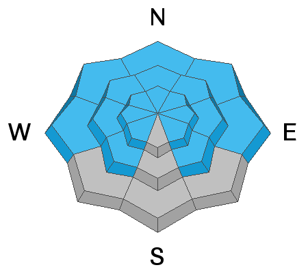
DANGEROUS AVALANCHE CONDITIONS EXIST. Significant snowfall combined with wind over the past week has stressed underlying persistent weak layers to their breaking point. The avalanche danger is CONSIDERABLE on steep slopes facing NW-N-E at all elevations, and deep and dangerous human triggered avalanches are likely in these areas. Avalanches can be triggered from a distance and the danger increases with elevation becoming most acute on upper elevation slopes facing N-E. Human triggered avalanches remain all but certain in these areas. Most S-W facing slopes have a MODERATE danger though extra caution should be applied on slopes facing SE.
Low
Moderate
Considerable
High
Extreme
Learn how to read the forecast here
Special Avalanche Bulletin
Special Announcements
With great sadness, the Utah Avalanche Center reports that a 57-year old skier, Kurt Damschroder of Park City, was killed in a backcountry avalanche off of Squaretop Peak, located on the Park City Ridgeline. The preliminary information can be found HERE. Our thoughts go out to those affected by this tragic accident, especially the family and friends of the victim.
It was an active weekend throughout the state. Manti-Skyline forecaster Brett Kobernik has compiled events in this short video.
The Geyser Pass Road will be closed for plowing this morning.
The Lower Utah Nordic Alliance (LUNA) groomed into Gold Basin on Sunday. They plan to groom over Geyser Pass today.
Weather and Snow
24 Hour Snow 0" 72 Hour Snow 12" Base Depth in Gold Basin 44" Wind S 15-20 G27 Temp 25F
Southerly winds bumped up a bit overnight and temps have remained quite warm. Today look for high clouds to move in from the SW ahead of a trough approaching the Pacific coast. Southerly winds will be light to moderate, and high temps at 10,000' will be right around freezing. SW flow will continue to feed mid-level moisture into the region through Tuesday bringing more clouds and keeping temperatures warm. Our next shot at snow comes Wed night into Thu as the next Pacific storm system moved into the region.
Wind, temperature, humidity on Pre Laurel Peak (11,700')
Snotel site near Geyser Pass Trailhead (9600')
Storm totals at the Gold Basin study plot (10,000')
Snowpack Discussion
Snow totals from last week are up to 32" in Gold Basin with more than 2.5" of water weight or snow water equivalent (SWE). The new snow combined with sustained southerly winds mid-last week has built slabs 2'-3' deep over top of the weak, underlying snowpack, and conditions are primed for deep and dangerous human triggered avalanches. Several natural avalanches have occurred and in my travels on Saturday, I was able to remotely trigger a large and un-survivable avalanche. Observers over the weekend reported widespread collapsing and reactive stability test results. Travis Nauman sent in this observation from Saturday, and Reed Kennard sent in this observation from Sunday. You can see my description of the current snowpack structure in the video below.
Recent Avalanches
Many natural avalanches have occurred over the past week as incremental loading has stressed our weak snowpack to the breaking point. A large, natural avalanche released on the Northeast face of Mount Tukno sometime Friday night, and yesterday I was able to trigger a large avalanche into Horse Creek. Details in the video below. Here is a complete list of recent avalanches.
Ad
Avalanche Problem #1
Persistent Weak Layer
Type
Location
Likelihood
Size
Description
Persistent weak layers of weak, sugary, faceted snow are present on all north-facing aspects at all elevations. Slabs 2'-3' deep exist on top of these weak layers near treeline and above. Additionally, cold temperatures and a lack of snowfall for most of January has formed weak layers around the compass and elevation zones. With the recent snow, West, Southwest, and Southeast aspects now harbor dangerous slabs overlying weak faceted snow.
Additional Information
Our avalanche beacon training park is up and running for the season. Thanks to Moab Gear Trader and Talking Mountain Yurts for their support of this valuable resource!
General Announcements
This forecast is from the U.S. Forest Service, which is solely responsible for its content. This forecast describes general avalanche conditions and local variations always occur.