


Forecast for the Moab Area Mountains
Issued by Chris Benson on
Tuesday morning, February 2, 2021
Tuesday morning, February 2, 2021
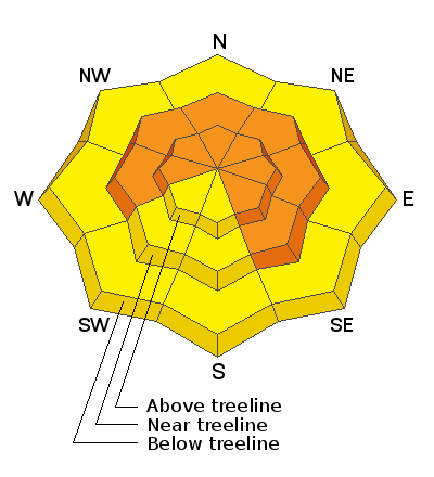
DANGEROUS AVALANCHE CONDITIONS EXIST. Significant snowfall combined with wind over the past week has stressed underlying persistent weak layers to their breaking point. The avalanche danger is CONSIDERABLE on steep slopes facing NW-N-E-SE near and above treeline, and deep and dangerous human triggered avalanches are likely in these areas. Avalanches can be triggered from a distance and the danger increases with elevation becoming most acute on upper elevation slopes facing N-E. Human triggered avalanches remain likely in these areas. At lower elevations, S-W facing slopes have a MODERATE danger though extra caution should be applied on slopes facing SE.
Low
Moderate
Considerable
High
Extreme
Learn how to read the forecast here
Special Avalanche Bulletin
 Special Announcements
With great sadness, the Utah Avalanche Center reports that a 57-year old skier, Kurt Damschroder of Park City, was killed in a backcountry avalanche off of Squaretop Peak, located on the Park City Ridgeline. The preliminary information can be found HERE. Our thoughts go out to those affected by this tragic accident, especially the family and friends of the victim.
The Geyser Pass Road was plowed yesterday morning. Conditions are snow-packed and icy and all-wheel drive is recommended.
The Lower Utah Nordic Alliance (LUNA) has groomed all trails from Geyser Pass through Gold Basin with the classic track as of yesterday.
 Weather and Snow
24 Hour Snow 0" 72 Hour Snow 0" Base Depth in Gold Basin 44" Wind S 10-15 Temp 30F
Yesterday, light southerly winds increased briefly in the afternoon with steady 20 mph winds and gusts into the 30 mph range before diminishing overnight. Overcast skies, southwest flow, and warm-air advection helped produce warm daytime temps reaching 39 F yesterday at 10,000'. Today, expect the overcast skies to dissipate breifly, followed by increasing clouds in the late afternoon/evening. High temperatures in the low 30s and southwesterly winds 10-20 mph. Models (including the groundhog!) are moving towards agreement and show that the base of the approaching trough will move over eastern Utah and western Colorado Wednesday evening. The good news is our area may receive a light burst of snow Wednesday night (2-4"). The bad news is a strong jet streak directly overhead will lead to strong winds tomorrow afternoon into Thursday.
Wind, temperature, humidity on Pre Laurel Peak (11,700')
Snotel site near Geyser Pass Trailhead (9600')
Storm totals at the Gold Basin study plot (10,000')
Snowpack Discussion
It has been over 72 hours since our last loading event, which added much needed snow to our thin, weak, and meager snowpack. Warm temperatures and time have helped the snowpack adjust to the significant snow totals from last week (32" in Gold Basin with ~ 2.5" of snow water equivalent). However, dangerous slabs 2'-3' deep are perched above the weak underlying snowpack, and conditions are primed for deep and dangerous human triggered avalanches. Yesterday, observations in the La Sal Pass area were a mixed bag. No recent avalanches were observed, nor did we observe cracking or collapsing. Southerly slopes were moist and a 2-3 cm melt freeze crust has formed at mid and low elevations. Snowpack results suggest that the most recent snow has bonded fairly-well to the old snow surface. Our primary layer of concern is deeper in the snowpack, where persistent weak layers formed in January and earlier in the season continue to be reactive in snowpack tests. This poor snowpack structure is widespread and still adjusting to the recent snow and wind. While reports of natural avalanches and cracking/collapsing may be becoming less frequent, it is still possible and even likely, to trigger a large and destructive avalanche with the additional weight of a skier or rider, especially in places where snow has been thickened by last week's wind.
Here's a video of Eric Trenbeath describing the situation:
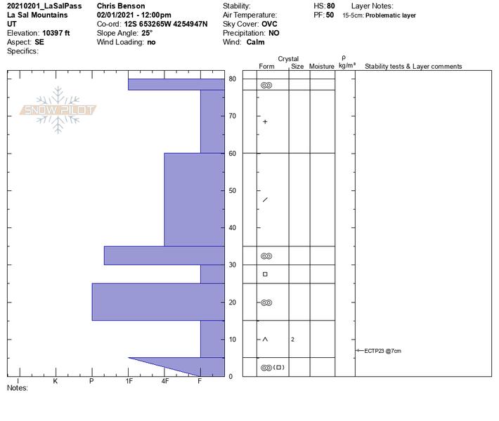
This snowpit recorded yesterday on a SE aspect near treeline suggests that dangerous slabs are lurking on SE aspects. Although they may be becoming harder to trigger, weak layers remain, and will continue to "wake-up" with each additional loading event.
 Recent Avalanches
Many natural avalanches have occurred over the past week as incremental loading has stressed our weak snowpack to the breaking point. A large, natural avalanche released on the Northeast face of Mount Tukno sometime Friday night, and on Saturday 1/30/2021 a remote trigger of a large avalanche in Horse Creek. Details in the video below. Here is a complete list of recent avalanches.

Avalanche Problem #1
Persistent Weak Layer
Type
Location
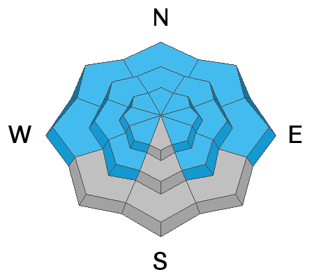
Likelihood
Size
Description
Persistent weak layers of weak, sugary, faceted snow are present on all north-facing aspects at all elevations. Slabs 2'-3' deep exist on top of these weak layers near and above treeline. Additionally, cold temperatures and a lack of snowfall for most of January has formed weak layers around the compass and elevation zones. With the recent snow, West, Southwest, and Southeast aspects now harbor dangerous slabs overlying weak faceted snow.
Avalanche Problem #2
Wet Snow
Type
Location
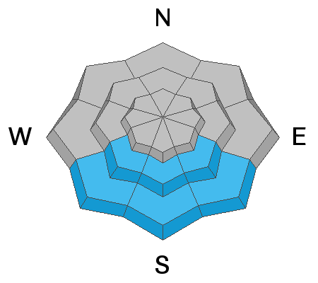
Likelihood
Size
Description
A light freeze overnight, light winds, and warm temperatures in today's forecast may lead to lower elevation southerly slopes producing some wet-loose activity if skies clear. Be on the lookout if things begin to warm up.
Additional Information
Our avalanche beacon training park is up and running for the season. Thanks to Moab Gear Trader and Talking Mountain Yurts for their support of this valuable resource!
General Announcements
This forecast is from the U.S. Forest Service, which is solely responsible for its content. This forecast describes general avalanche conditions and local variations always occur.