The Colorado Avalanche Information Center reports that three skiers are still missing after a large avalanche in the San Juan Mountains. You can read the preliminary report
HERE. Additionally, the final report from a fatal accident on Saturday near the Park City Ridgeline can be read
HERE. Our thoughts go out to those affected by this tragic accident, especially the family and friends of the victims.
The Geyser Pass Road was plowed Monday morning. Conditions are snow-packed and icy and all-wheel drive is recommended.
The Lower Utah Nordic Alliance (LUNA) has groomed all trails from Geyser Pass through Gold Basin with the classic track as of Monday. Unfortunately, some of the grooming has been disrupted due to motorized use.
24 Hour Snow 0" 72 Hour Snow 0" Base Depth in Gold Basin 44" Wind SSW 20 G40 Temp 31F
Yesterday, southerly winds ranged from 15-20 mph. An overcast cloud layer at about 10,000' obscured the mountains for much of the day. With intermittent clear skies and these clouds acting like a blanket, we had yet another warm day with temps reaching 37 F yesterday at 10,000'. Temperatures have been hovering near freezing overnight. Today, expect broken skies followed by increasing clouds and lowering ceilings throughout the day. High temperatures in the mid 30s and steady southwesterly winds 30-40 mph with gusts up to 50 mph before shifting to the northwest and dying down. Currently, there isn't much snow available for transport so not expecting wind slabs to form. The approaching storm will start warm, with a mix of rain/snow with snow starting at around 8,000'. Thunder-snow is a possiblity. While scattered storms may occur throuought the day, the main pulse will arrive this evening with an expected 1-3" from this system.
Snowpack Discussion
It has been 4 days since our last loading event, which added much needed snow to our thin, weak, and meager snowpack. Warm temperatures over the last two days have helped the recent snow settle and adjust to the significant snow totals from last week. At sunny, lower elevation areas, reports of roller-balls and moist snow confirm that some wet-loose activity probably occured yesterday. Without a solid overnight-freeze, much of the snowpack remains in a weakend state from warm daytime temperatures. On more northerly aspects at higher elevations, dangerous slabs 2'-3' deep are perched above the weak underlying snowpack, and conditions are primed for deep and dangerous human triggered avalanches.
Observations from Monday (2/1/2021) in the La Sal Pass area were a mixed bag. No recent avalanches were observed, nor did we observe cracking or collapsing. Southerly slopes were moist and a 2-3 cm melt freeze crust has formed at mid and low elevations. Snowpack results suggest that the most recent snow has bonded fairly-well to the old snow surface. Our primary layer of concern is deeper in the snowpack, where persistent weak layers formed in January and earlier in the season continue to be reactive in snowpack tests. This poor snowpack structure is widespread and still adjusting to the recent snow and wind. While reports of natural avalanches and cracking/collapsing may be becoming less frequent, it is still possible and even likely, to trigger a large and destructive avalanche with the additional weight of a skier or rider, especially in places where snow has been thickened by last week's wind.
Here's a video of Eric Trenbeath describing the situation:
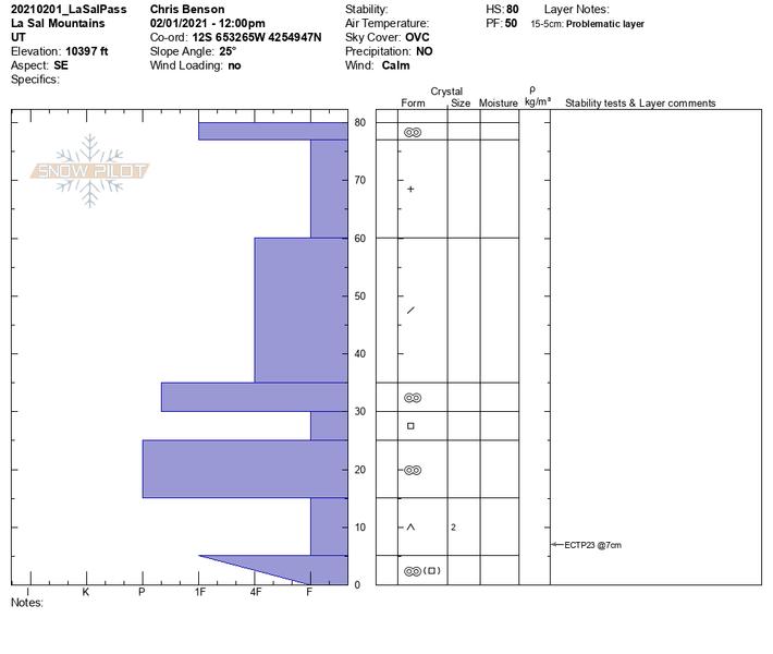
This snowpit from 2/1/2021 on a SE aspect near treeline suggests that dangerous slabs are lurking on SE aspects. Although they may be becoming harder to trigger, weak layers remain, and will continue to "wake-up" with each additional loading event.
Large, destructive and deadly avalanches continue to be reported from adjacent zones. On Monday, a large avalanche on a NE aspect at 11,500' caught and carried four skiers, three of which are still missing. Yesterday, a
near miss occured on the Skyline at 10,000' on a north-aspect. Both of these events highlight that persistant slab avalanches are sensitive to triggering, and may break wider and farther than you might expect.