A tragic avalanche accident in the San Juan Mountains of Colorado buried three skiers on Monday, and recovery efforts are ongoing. Here is the
preliminary report from the CAIC.
And it is with great sadness, the Utah Avalanche Center reports that a 57-year old skier, Kurt Damschroder of Park City, was killed Saturday in a backcountry avalanche off of Square Top Peak, located on the Park City Ridgeline. The final accident report can be found
HERE. Our thoughts go out to those affected by this tragic accident, especially the family and friends of Kurt.
The Geyser Pass Road was plowed Monday morning. Conditions are snow-packed and icy and all-wheel drive is recommended.
The Lower Utah Nordic Alliance (LUNA) has groomed all trails from Geyser Pass through Gold Basin with the classic track as yesterday.
24 Hour Snow 2" 72 Hour Snow 2" Base Depth in Gold Basin 44" Wind NW 10-20 Temp 4F
The mountains picked up a couple of inches of snow overnight and a few clouds are lingering over the mountains this morning. Pre-Laurel winds are unavailable this morning but other regional stations and upper air charts show NW winds at 10-20 mph. Look for sunny skies today with high temps in the upper teens. Northwest flow aloft prevails across the Intermountain region bringing chances of snow to the north while southern Utah looks to remain dry through the weekend.
Snowpack Discussion
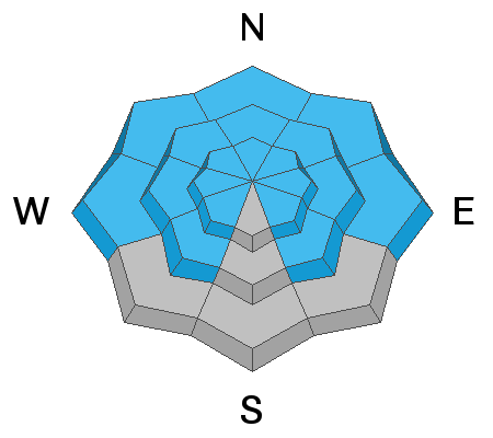
It has been 5 days since our last loading event. Warm temperatures have helped the recent snow settle and adjust, but on northerly aspects, dangerous slabs 2'-3' deep are perched above the weak underlying snowpack. These slabs remain primed and ready for human triggers. South-facing slopes have taken a hit from the sun and warm temps and are largely crusted over. Moderate southerly winds yesterday also scoured exposed terrain as well as transported a bit of snow. A shift to the north today will have a similar effect on exposed, northerly aspects.
Chris Benson was up yesterday and produced the following video on conditions and current snowpack structure.
Large, destructive, and deadly avalanches continue to be reported from adjacent zones. On Monday, a large avalanche on a NE aspect at 11,500' caught and carried four skiers, three of which were tragically killed. On Monday, a
near-miss occurred on the Manti-Skyline at 10,000' on a north-aspect. Both of these events highlight that deep and dangerous slab avalanches failing on a persistent weak layer remain sensitive to human triggers.


