Forecast for the Logan Area Mountains

Paige Pagnucco
Issued by Paige Pagnucco for
Saturday, March 9, 2024
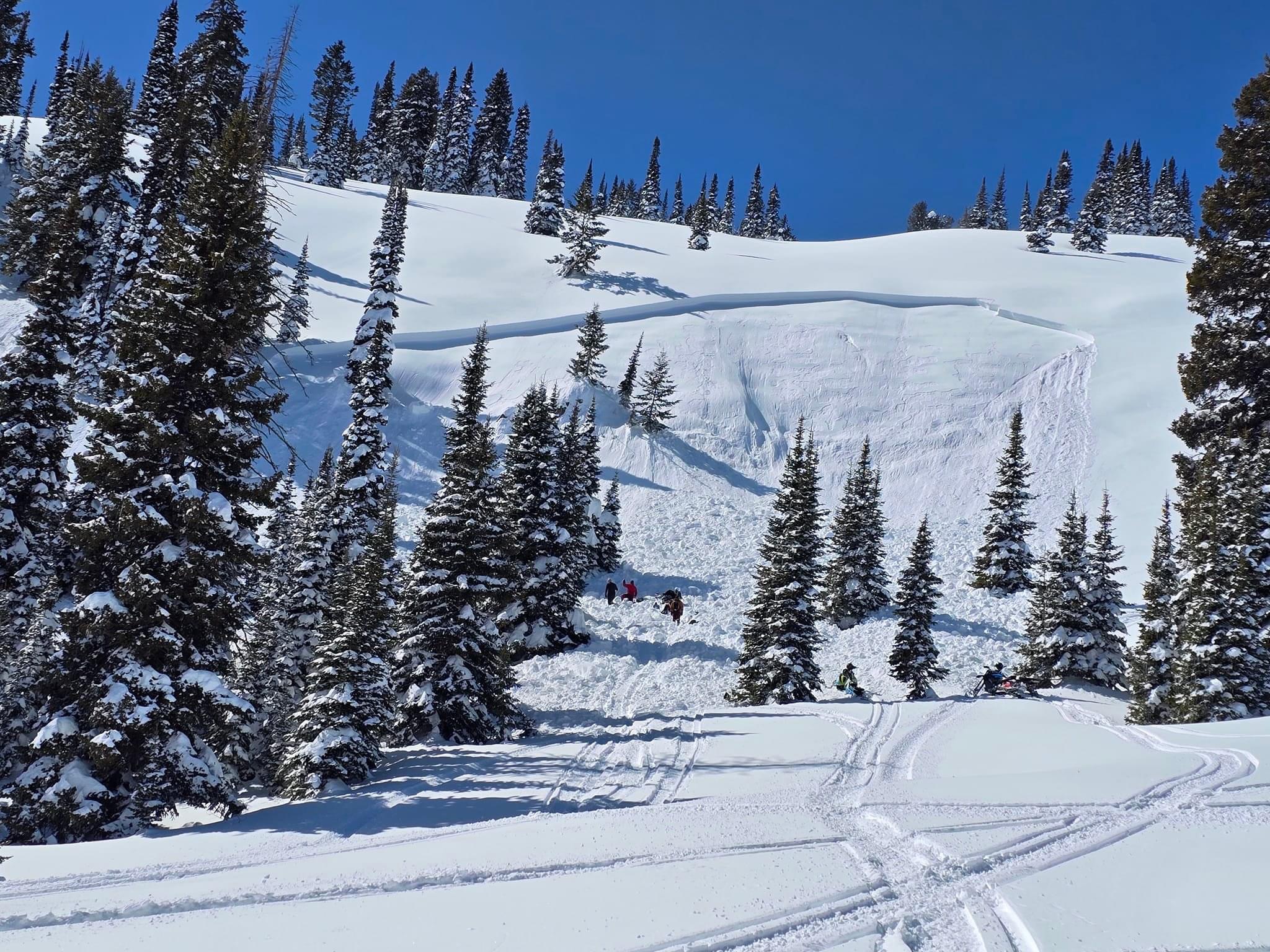
The avalanche danger is LOW this morning but will rise to MODERATE as the day warms up. Human-triggered avalanches are possible on steep slopes where the snow becomes saturated from the strong March sun and warm temperatures. Avoid being on or under large overhanging cornices which may break back further than expected and may also trigger an avalanche below.
  • Evaluate snow and terrain carefully as temperatures rise.
​​​​​
Low
Moderate
Considerable
High
Extreme
Learn how to read the forecast here
Special Announcements
We are seeking a passionate individual to join us as Executive Director of the nonprofit Utah Avalanche Center. Click here for more information.
Weather and Snow
You will find very good settled powder in shady upper and mid-elevation terrain. Sunny slopes will have a decent crust this morning and become damp as the day warms up. The snow from the past week's storms is significantly deeper at higher elevations but has settled nicely and is very supportable (read - hard to get stuck).

It's a bit warmer this morning across mountain weather stations; a prelude to today's abundance of warmth and sunshine. It's 22° F this morning, and there's 116 inches of total snow containing 134% of normal SWE at the Tony Grove Snotel. It's 18° F at our new Card Canyon weather station (8750') and there is 88"of total snow. This morning, it's 25° F and winds are blowing from the northeast at 5 to 10 mph at the 9700' CSI Logan Peak weather station. At 9500' on Paris Peak, light winds are blowing from the north-northeast, and it's 23° F.

Expect sunny skies today, with 8500' high temperatures around 35° F, and winds blowing around 5 to 10 mph from the south along the high ridges. Expect clear skies tonight with temperatures dropping back down into the teens. Sunday looks the same with warmer high temperatures and winds from the southwest slowly ramping up ahead of Monday's storm. Snow is likely on Monday (2 to 4 inches of accumulation) and more is likely with a stronger system that arrives Tuesday (4 to 8 inches of accumulation).
Recent Avalanches
We noticed cornice fall and very shallow loose sluffs that occurred during the past week's storm. We also heard about a rider-triggered wind slab avalanche near Midnight Mountain, but we have few details.

Check out all local observations and avalanches HERE.
Ad
Avalanche Problem #1
Wet Snow
Type
Location
Likelihood
Size
Description
  • Shallow loose wet avalanches are possible at lower elevations, and deeper wet avalanches are possible in sunny terrain up higher as daytime temperatures warm.
  • In steep terrain, watch for terrain traps below that small loose avalanches could carry you into like trees, gullies, benches, sinks, or cliff bands.
  • Pinwheels and roller balls are indicators the snow is becoming unstable.
  • If the snow you're riding on becomes saturated, move to a cooler aspect or elevation.
Avalanche Problem #2
Normal Caution
Type
Location
Likelihood
Size
Description
The snowpack is generally stable across the Logan zone but LOW danger does not mean NO danger.
  • You may trigger a wind slab avalanche in isolated terrain where the wind has deposited large amounts of snow over the past week.
  • Stay well away from and out from under overhanging cornices, which may break further back and be much larger than expected.
  • Cornice falls could trigger avalanches on slopes below.
  • Only expose one person at a time when crossing steep slopes.
  • Make sure everyone in your party has a beacon, shovel, and probe and knows how to use them.
Additional Information
General Announcements
-National Forest Winter Recreation Travel Maps show where it's open to ride: UWCNF Logan, Ogden LRD Tony Grove, Franklin Basin CTNF Montpelier
-Listen to your very own Logan Zone avalanche forecasters on the UAC Podcast HERE.
-Read my recent blog about wind, drifting, and avalanches HERE.
-Sign up for forecast region-specific text message alerts. You will receive messages about changing avalanche conditions, watches, and warnings...HERE.
-For all questions on forecasts, education, Know Before You Go, events, online purchases, or fundraising, call 801-365-5522.
-To report an avalanche or submit an observation from the backcountry, go HERE.
-Come practice companion rescue at the Franklin Basin TH Beacon Training Park. It's free and open to everyone. For easy user instructions, go HERE.
-We will update this forecast by 7:30 AM tomorrow.
This forecast is from the U.S.D.A. Forest Service, which is solely responsible for its content. This forecast describes general avalanche conditions, and local variations always occur.