Forecast for the Logan Area Mountains

Toby Weed
Issued by Toby Weed for
Friday, March 8, 2024
Heightened avalanche conditions exist in the backcountry, and the danger is MODERATE. People could trigger large cornice falls and slab avalanches of wind-drifted snow in drifted upper-elevation terrain steeper than 30°. The higher-angled March sun will be out in force, and loose wet avalanches will become increasingly possible on steep sunny slopes in the heat of the day.
  • Evaluate snow and terrain carefully.
  • Stay well clear of and out from under overhanging cornices.
  • Avoid being on or under steep, sunny slopes with saturated surface snow in the heat of the day.
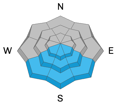
​​​​​
Low
Moderate
Considerable
High
Extreme
Learn how to read the forecast here
Special Announcements
We are seeking a passionate individual to join us as Executive Director of the nonprofit Utah Avalanche Center. Click here for more information.
Weather and Snow
We've found very nice powder riding conditions in shady upper and mid-elevation terrain. By afternoon, the sun had damaged sunny slopes and meadows, and there are likely to be some slopes with sun-crust on the snow surface today. The new snow on top of a dusty crust formed on Leap Day and March 1 is much shallower at lower elevations.

The Tony Grove Snotel at 8400' reports around 4.4" SWE (snow water equivalent) since March 1. It's 9° F this morning, and there's 116 inches of total snow containing 134% of normal SWE. It's also 9° F at our new Card Canyon weather station (8750') there is 90"of total snow. This morning, it's 9° F and winds are blowing from the north-northwest 10 to 15 mph at the 9700' CSI Logan Peak weather station. At 9500' on Paris Peak, light winds are blowing from the north-northeast, and it's 7° F.

Expect sunny skies today, with 8500' high temperatures expected to be around 26° F, and the winds will blow around 10 mph from the northeast along the high ridges. Expect mostly clear skies tonight with temperatures dropping back down to around 9° F. Fair weather is expected in the mountains this weekend, with daytime high temperatures at upper elevations near 32° F tomorrow and 35° F on Sunday.
Snow is likely on Monday (with 2 to 4 inches of accumulation) and more is likely during the first few days of next week.
Recent Avalanches
We noticed several small, fresh, loose avalanches of wet snow on steep slopes in Logan Canyon yesterday afternoon. Despite being pretty shallow, some of these produced sizable piles of cement-like debris.
Check out all local observations and avalanches HERE.
Ad
Avalanche Problem #1
Wind Drifted Snow
Type
Location
Likelihood
Size
Description
Human-triggered avalanches of wind-drifted snow remain possible in steep, drifted terrain. Very strong winds earlier in the week loaded snow onto leeward terrain, creating thick wind slabs and building out already large overhanging cornices.
  • Watch for and avoid stiffer wind drifts on the lee side of major ridges, on corniced slopes, and in and around terrain features like cliff bands, sub-ridges, gully walls, and mid-slope rollovers.
  • Stiff wind slabs could be hidden from view by several inches of fresh snow. These could be stubborn, allowing a person to get far out on them before releasing. Shooting cracks are a sign of unstable snow.
  • Stay well away from and out from under devious overhanging cornices, which may break further back and be much larger than expected. Cornice falls could trigger wind slab avalanches on slopes below.
Avalanche Problem #2
Wet Snow
Type
Location
Likelihood
Size
Description
  • Shallow loose wet avalanches are possible at lower elevations, and deeper wet avalanches are possible in sunny terrain up higher as daytime temperatures warm or the sun peaks out from behind the clouds.
  • In steep terrain, watch for terrain traps below that small loose avalanches could carry you into; like trees, gullies, benches, sinks, or cliff bands.
Additional Information
We saw several small fresh, natural, wet loose avalanches in Logan Canyon on Thursday afternoon.
Wind drifting off the Wellsville Range (Jason Wooden, 3-5-2024)
General Announcements
-National Forest Winter Recreation Travel Maps show where it's open to ride: UWCNF Logan, Ogden LRD Tony Grove, Franklin Basin CTNF Montpelier
-Listen to your very own Logan Zone avalanche forecasters on the UAC Podcast HERE.
-Read my recent blog about wind, drifting, and avalanches HERE.
-Sign up for forecast region-specific text message alerts. You will receive messages about changing avalanche conditions, watches, and warnings...HERE.
-For all questions on forecasts, education, Know Before You Go, events, online purchases, or fundraising, call 801-365-5522.
-To report an avalanche or submit an observation from the backcountry, go HERE.
-Come practice companion rescue at the Franklin Basin TH Beacon Training Park. It's free and open to everyone. For easy user instructions, go HERE.
-We will update this forecast by 7:30 AM tomorrow.
This forecast is from the U.S.D.A. Forest Service, which is solely responsible for its content. This forecast describes general avalanche conditions, and local variations always occur.