

Toby Weed
Forecaster
Wind, Drifting, and Avalanches
According to the National Oceanic and Atmospheric Administration, “Wind is the movement of air caused by the uneven heating of the Earth by the sun.” Indeed, other environmental elements are at play, like gravity, fluid and gas dynamics, weather systems, and the earth’s spinning, but causes aside, NOAA is clear, “Wind is simply air in motion.” In the mountains, wind has a considerable influence on avalanche phenomena. Drifting of falling snow and snow already on the ground creates heavy deposits or drifts in avalanche-starting zones. These drifts can fail as destructive slab avalanches on slopes steeper than 30°. As a veteran avalanche forecaster in the Intermountain West, I’ve been tremendously impressed by wind-caused avalanche activity.
It is essential for people who study avalanches to understand the effect of wind in terrain on the snow. Recent wind parameters must be considered when forecasting avalanche activity at any scale. Loading of avalanche-starting zones caused by drifting snow can be estimated by examining wind speed and direction and correlating this with surface snow characteristics, precipitation rates, and snow density. Each storm or loading event is different, but similar weather produces similar avalanche activity, and wind speed and its direction are huge factors in determining which slopes are likely to receive critical loads.
Avalanche forecasters are often asked about how we describe wind direction. People are sometimes confused, unsure if we are describing the direction in which the wind is blowing or from where it is blowing. Wind direction is generally reported by the direction the wind is blowing from. If we say east wind, we say the wind is blowing from the east. In their online glossary, the National Weather Service states, "The true direction from which the wind is blowing at a given location (i.e., wind blowing from the north to the south is a north wind).” A quick Google search brings up the Wikipedia definition, "Wind direction is generally reported by the direction from which the wind originates.” The wind is described this way for many reasons, including our natural tendency to face into the wind, just as trout face upstream in the river currents.
Historically, people have used different instruments to measure and visualize wind direction, including banners and pennants used by mariners and wind socks used in aviation, but we describe wind by its direction of origin because a wind vane points in the direction the wind blows from. Wind vanes are wind direction instruments introduced by the Greeks over 2000 years ago. Elevated off the ground, they are often shaped like arrows with a rudder blade on the tail end and mounted on a shaft or pole. The wind catches the tail rudder and rotates the tip into the wind, showing the direction from which the wind is coming. Wind speed measurement is also critical in understanding wind drifting. Winds must be strong enough to pick up and transport snow of varying densities, but if too strong, the airborne snow will be blown far beyond avalanche starting zones. Avalanche forecasters rely on mountain weather stations equipped with modern wind sensors or anemometers that measure and log wind speed and direction. One limitation of these instruments is that they can only measure horizontal wind speed and direction, leaving the vertical component unmeasured as winds blow through complex, three-dimensional mountain terrain.
It is necessary to understand how different kinds of drifting load slopes in order to understand the effects of wind direction and strength. It is generally understood that drifts or wind slabs will form on lee slopes, slopes facing the azimuth direction from which the wind blows. Avalanche Canada describes lee slopes in their glossary: "The term leeward, or lee, refers to slopes that are oriented away from the wind. If winds are strong enough, snow from windward slopes can be redistributed or blown to leeward areas, causing them to become loaded. Wind slabs often form on lee aspects due to this wind transport."
According to Perla and Martinelli in the original Avalanche Handbook, Accelerating wind picks up the snow grains in fetch areas, breaks them apart, and deposits them packed together more tightly than the non-wind-affected snow, forming denser drifts or wind slabs where the wind decelerates, also known as deposition zones. When wind drifts snow across a slope, wind slabs often form vertically on the slope due to cross-loading.
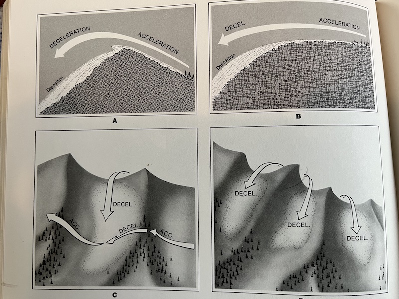
A, transport from the windward to the lee. side of a ridge. B, transport to a region of increasing slope steepness. C, transport into gullies from side and top. D, transport through notches in a ridgecrest. (Avalanche Handbook)
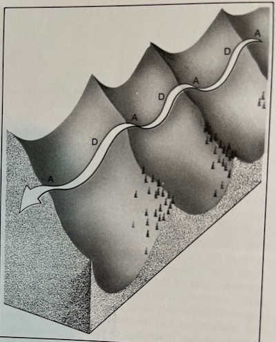
Flow across a slope. Acceleration regions are designated A. deceleration B. (Avalanche Handbook)
The Conceptual Model of Avalanche Hazard (2017 Grant Statham and others) defines two drifting mechanisms;
- Redeposition: drifting snow on the ground Redeposition leads to the classic formation of soft or harder wind slabs and can lead to “avalanches of wind-drifted snow.” Drifts or wind slabs form in and around terrain features where wind decelerates, and the airborne snow is deposited.
- Preferential Deposition: drifting of snow that is falling. This occurs when snow from the air column is deposited directly into a lee (wind deceleration) area. Preferential deposition causes the formation of storm slabs and leads to “soft slab avalanche of new snow.”

Redeposition (a) occurs when snow already on the ground is transported. Preferential deposition (b) occurs when snow from the air column accumulates in a specific area due to wind.
Avalanche forecasters can easily fit redeposited snow in the "wind-drifted snow" avalanche problem. Wind slabs formed by redeposition are easily identified and are found in wind deceleration zones high on lee slopes or in and around terrain features. Slabs formed by preferential deposition are a bit more challenging to categorize. In her presentation at the 2023 International Snow Science Workshop in Bend, OR, Nathalie de Leeuw argued that in the US and Canada there is considerable crossover in descriptions of preferentially deposited snow. Forecasters often describe the avalanche problem created by preferential deposition as either a wind slab problem or a storm slab problem. Regardless, both of these problems are related to drifting, and both redeposition and preferential deposition occur during storms, and when coupled with heavy accumulation and a persistent weak layer, create the largest avalanches in the mountains of northern Utah.
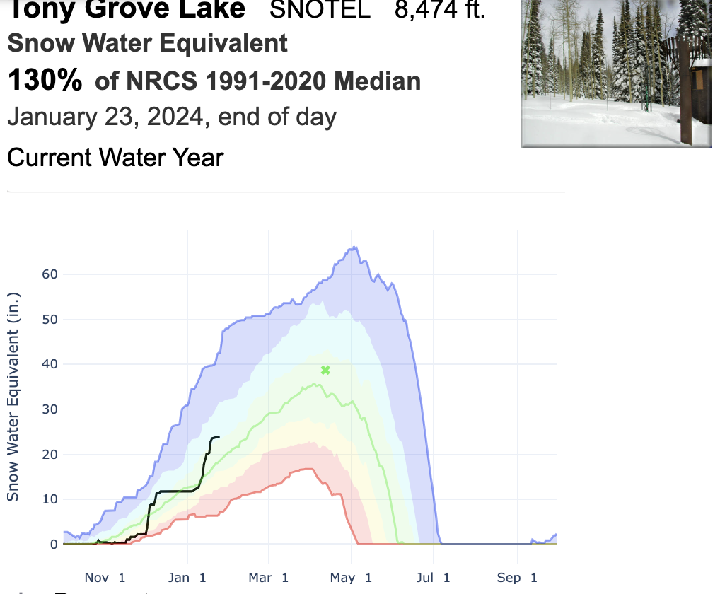

The effect of wind on avalanche formation is somewhat difficult to conceptualize because of the different types of drifting that occur during storm periods. Here is a graphical look at a recent storm cycle in the Logan Zone, in which the Tony Grove Snotel reported a whopping 12" of SWE accumulation between January 4 and January 21.
Here's a look at the Tony Grove Lake Snotel graph..
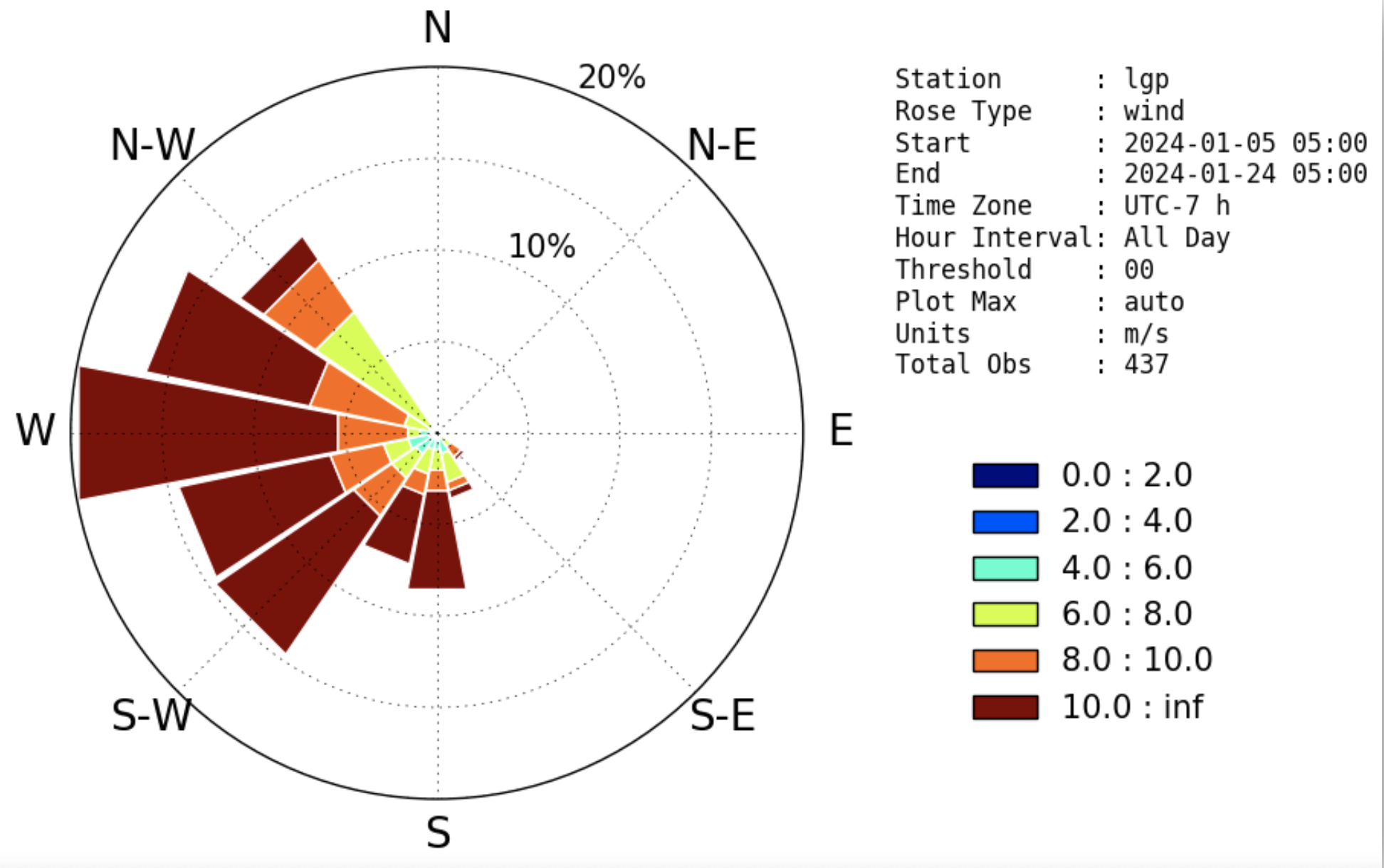
Here is a wind "rose plot" (utah.edu) from Logan Peak, including wind speed data from January 5 through January 24.
Below is an avalanche heat map from the UAC showing the rose location of recorded avalanche activity in the Logan Zone during that time frame. Notice that most avalanches occurred on east-facing slopes, which are lee slopes during this time according to the above wind rose.
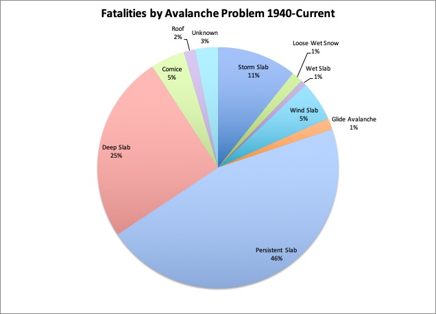
Here's an up-to-date graph of Fatalities by Avalanche Problem...
Hopefully, this is food for thought; a good reason to pay attention to how the wind blows.
Good job Toby.
Liam Fitzgerald (not verified)
Wed, 2/21/2024
- reply


