Forecast for the Logan Area Mountains

Nikki Champion
Issued by Nikki Champion for
Sunday, March 10, 2024
The overall avalanche danger is LOW this morning but could rise to MODERATE on the southern end of the compass as the day warms up.
Pay attention to changing conditions and avoid being on steep solar aspects if the snow has become wet and unsupportable. Steer clear of being on or under large overhanging cornices, which may break back further than expected and may also trigger an avalanche below.
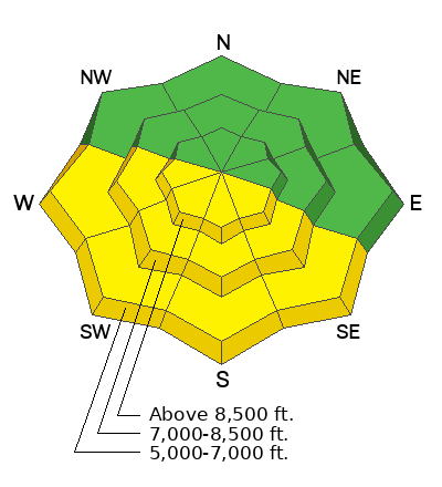
Low
Moderate
Considerable
High
Extreme
Learn how to read the forecast here
Special Announcements
We are seeking a passionate individual to join us as Executive Director of the nonprofit Utah Avalanche Center. Click here for more information.
Weather and Snow
This morning, under clear skies, temperatures are warm across the range. As of 3AM, it was 30°F, and there's 111 inches of total snow at the Tony Grove Snotel. As of 6AM, it was already 27°F at our new Card Canyon weather station (8750'), and there are 86 inches of total snow. At 9700' CSI Logan Peak weather station, it's 25°F, and winds are blowing from the southwest at 25-30 mph. At 9500' on Paris Peak, winds have increased with gusts up to 30 mph, blowing from the southwest, and it's 22°F.
Today will be another day of strong sunshine, with temperatures warming into the upper 30s°F at upper elevations and the mid-40s°F at low and mid-elevations. Winds will remain from the west-southwest and continue to increase throughout the day, averaging 15-20 mph and gusting up to 30 at mid-elevations, with gusts near 45 at upper elevation ridgelines.
Outlook: On Monday, winds will start blowing as a new storm system approaches. Snow is likely on Monday (2 to 4 inches of accumulation), and more is likely with a stronger system that arrives Tuesday (4 to 8 inches of accumulation).
You can still find lingering good-settled powder in shady upper and mid-elevation terrain, though the cold compass continues to shrink. Sunny slopes will have a decent crust this morning and become damp as the day warms up. The snow from the past week's storms is significantly deeper at higher elevations but has settled nicely and is very supportable (read - hard to get stuck).
Recent Avalanches
The only report of a slab avalanche throughout this last cycle came in yesterday; a rider was caught, carried, and their sled was fully buried on the NE side of Midnight Mountain. This avalanche failed as a hard slab of wind-drifted snow. The avalanche failed at 3 feet and 175 feet, and ran close to 300 feet. Chad and Michael Davis were able to make their way up there yesterday (See Video Below). Find the full observation HERE.
Otherwise quiet in the backcountry, reports of cornices continue to grow.

Check out all local observations and avalanches HERE.
Ad
Avalanche Problem #1
Wet Snow
Type
Location
Likelihood
Size
Description
The elevated winds should keep the wet snow at bay today, but with such strong sunshine and warm temperatures, there is still the potential to trigger wet-loose avalanches on steep, sunny slopes.
Wet snow is the easiest avalanche problem to avoid; simply move to shady slopes once the snow surface becomes wet. Signs that the snow surface is becoming wet include rollerballs, pinwheels, and the snow surface no longer being supportable. Remember, even a small avalanche can have a detrimental outcome in consequential terrain. Watch for terrain traps.
Avalanche Problem #2
Normal Caution
Type
Location
Likelihood
Size
Description
The snowpack is generally stable across the Logan Zone, but LOW avalanche danger does not mean NO avalanche danger. In isolated areas, you may encounter:
  • Stubborn wind slab avalanches in isolated terrain where the wind has deposited large amounts of snow over the past few weeks. Rounded pillows that crack or collapse on approach are sure signs that the wind-drifts should be approached with caution.
  • Cornices present a real danger today as well. Give them a wider berth than expected. Cornice falls could trigger avalanches on slopes below.

Remember safe travel techniques: Only expose one person at a time when crossing steep slopes. Make sure everyone in your party has a beacon, shovel, and probe and knows how to use them.
Additional Information
General Announcements
-National Forest Winter Recreation Travel Maps show where it's open to ride: UWCNF Logan, Ogden LRD Tony Grove, Franklin Basin CTNF Montpelier
-Listen to your very own Logan Zone avalanche forecasters on the UAC Podcast HERE.
-Read my recent blog about wind, drifting, and avalanches HERE.
-Sign up for forecast region-specific text message alerts. You will receive messages about changing avalanche conditions, watches, and warnings...HERE.
-For all questions on forecasts, education, Know Before You Go, events, online purchases, or fundraising, call 801-365-5522.
-To report an avalanche or submit an observation from the backcountry, go HERE.
-Come practice companion rescue at the Franklin Basin TH Beacon Training Park. It's free and open to everyone. For easy user instructions, go HERE.
-We will update this forecast by 7:30 AM tomorrow.
This forecast is from the U.S.D.A. Forest Service, which is solely responsible for its content. This forecast describes general avalanche conditions, and local variations always occur.