Forecast for the Logan Area Mountains

Toby Weed
Issued by Toby Weed for
Wednesday, March 15, 2023
Rain is falling, natural avalanches are occurring, and there is HIGH danger of loose wet avalanches on lower elevation slopes this morning. Dangerous conditions also exist on drifted upper and mid elevation slopes where people could trigger large cornice falls and/or 1 to 3-foot-thick slab avalanches. Periods of heavy snow, and drifting from sustained strong west-southwest winds will to continue to elevate the danger.
The danger could to rise to HIGH in drifted terrain at upper elevations, long running natural avalanches entraining big piles of heavy wet snow are a concern, and people should avoid travel in avalanche terrain including avalanche paths and runouts. Stay off and well out from under slopes steeper than 30°
Low
Moderate
Considerable
High
Extreme
Learn how to read the forecast here
Special Announcements
The UAC is currently working with the operation involved in Thursday's fatal avalanche in the Uintas to prepare a report. Please be patient as we sort out the details of this complicated incident. A preliminary report is available HERE.
Please consider donating to the spring campaign to help our team implement innovative tools and better provide you with the information you rely on.
Weather and Snow
The next Pacific atmospheric river storm is here, dangerous avalanche conditions exist and heavy snow, rain, and drifting by strong west-southwest winds will continue to elevate avalanche danger in the backcountry.
The 8400' Tony Grove Snotel reports 6 inches of very heavy new snow overnight. It's 29° F this morning, and there is 135 inches of total snow. The wind is now blowing from the west-southwest 25 to 30 mph at the 9700' CSI Logan Peak weather station, having averaged in the 40s and gusted up to 67 mph overnight

The National Weather Service has continued a Winter Storm Warning for the Logan Zone through today. We are at a point in the season where direct action avalanches are the rule, and large natural avalanche events occur almost weekly, during each storm. Today's avalanches are being caused by heavy snowfall, drifting from strong winds, and rain on snow.
Here is the NWS point forecast for high elevations in the Central Bear River Range:
Today: Snow showers, mainly before 3pm. The snow could be heavy at times. Some thunder is also possible. Temperature falling to around 24 by 5pm. Wind chill values as low as 10. Windy, with a west southwest wind 27 to 32 mph decreasing to 18 to 23 mph in the afternoon. Winds could gust as high as 48 mph. Chance of precipitation is 90%. Total daytime snow accumulation of 4 to 8 inches possible.
Tonight: A 20 percent chance of snow showers before midnight. Mostly cloudy, with a low around 10. Wind chill values as low as -3. North wind 13 to 21 mph.
Thursday:A 20 percent chance of snow showers after noon. Mostly sunny, with a high near 26. Wind chill values as low as -3. North northeast wind 10 to 14 mph.
We'll see fair weather and even a little sun for the end of the week and heading into the weekend.
Recent Avalanches
  • A natural wet avalanche hit Highway 89 at the Dugway in Logan Canyon early this morning. The road is closed this morning for clean up, but will hopefully be able to reopen soon. (The road opened up again at 8:00)
  • Over the weekend, we observed evidence of widespread natural avalanche activity from Friday's warm and windy storm across the Logan Zone.
  • For a list of avalanches in the Logan Zone go HERE
  • It was a bit more active in the Wasatch Range yesterday. Find a list of all recent observations & avalanches from across Utah HERE.
Ad
Avalanche Problem #1
Wind Drifted Snow
Type
Location
Likelihood
Size
Description
Avalanches of wind drifted snow, 1 to 3 feet thick, are likely for people to trigger in windy terrain at upper and mid elevations. Natural avalanches will become more likely this afternoon as more heavy snow accumulates and is drifted into avalanche stating zones.
  • Avoid corniced slopes and stiffer drifts on steep slopes near ridges and in and around terrain features like cliff bands, sub-ridges, mid-slope break-overs, and gully walls.
  • The overhanging cornices on the high peaks and ridges have become huge with recent storms, so its a good idea to continue to stay well away and out from under them.
  • Avalanches of wind drifted snow failing on a persistent weak layer buried 1 to 3 feet deep are possible and might be triggered remotely or from a distance.
Avalanche Problem #2
Wet Snow
Type
Location
Likelihood
Size
Description
Warming temperatures and rain at lower elevations have created a HIGH avalanche danger. Natural and human triggered loose wet avalanches are likely today. Natural avalanche are occurring in Logan Canyon as I write.
  • More than normal snow cover exists even at very low elevations, and snow is unstable as it is saturated and loosened up by warmth and rain.
  • Loose avalanches of saturated snow could entrain large piles of very heavy snow and they threaten lower elevation trails, access roads, and some of my favorite fishing holes down on the river.
Additional Information
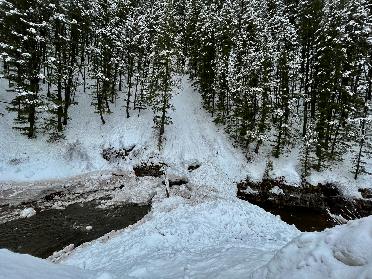
A recent natural wet avalanche crossed the Logan River below Temple Fork near the Blind Hollow TH

Roller Balls and pinwheels like these on the River Trail indicate potential for wet avalanches.
General Announcements
  • Please submit your observations from the backcountry HERE.
  • For a list of avalanche classes from the Utah Avalanche Center go HERE
  • For information on where you can ride your sled or snowbike, check out this map of the winter travel plan for the Logan and Ogden Ranger Districts HERE, and a close up of the Tony Grove and Franklin Basin Areas HERE.
This forecast is from the U.S.D.A. Forest Service, which is solely responsible for its content. This forecast describes general avalanche conditions and local variations always occur.