UDOT PLANNED AVALANCHE CLOSURES!!

Forecast for the Logan Area Mountains

Toby Weed
Issued by Toby Weed for
Wednesday, January 9, 2019
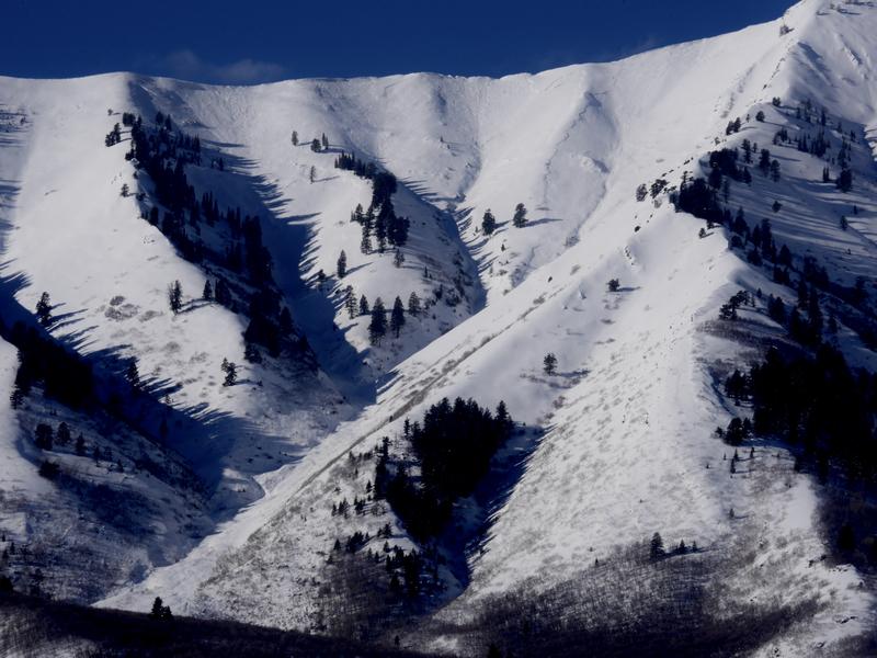
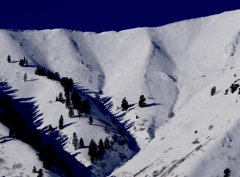
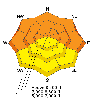
CONSIDERABLE: Dangerous human triggered avalanches are possible at all elevations, but more likely on drifted upper elevation slopes and lower elevation slopes with poor snow structure. You could trigger avalanches releasing on a persistent weak layer remotely or from a distance. Avalanches at lower elevations could impact unsuspecting people who are usually not at risk.
  • Use extra caution in the backcountry today.
  • Evaluate snow and terrain carefully, make conservative choices, and avoid steep slopes with wind drifted snow.
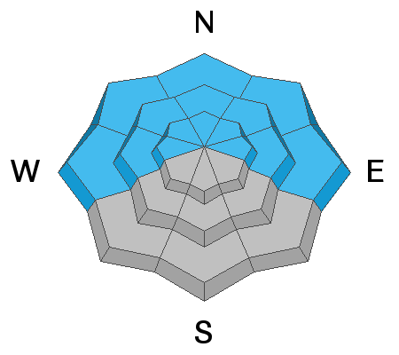
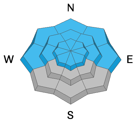
Low
Moderate
Considerable
High
Extreme
Learn how to read the forecast here
Weather and Snow
Heavy snow and drifting from strong southwest and west winds overloaded widespread weak snow at the beginning of the week, south winds picked up significantly overnight, and dangerous avalanches remain likely on drifted slopes today. The Tony Grove Snotel at 8400' picked up about 17" from the Sunday/Monday storm. It's 29º F and there's 50" of total snow containing 93% of average SWE. I'm reading 28º F at the 9700' CSI Logan Peak weather station, and south winds are currently averaging about 35 mph, with gusts in the 50s.
Evidence of a natural avalanche cycle in the Wellsville Range became apparent with clearing yesterday, 1/7/19.
High pressure will dominate midweek, with a weak weather system moving through during the latter portion of the week. Today will be mostly sunny, with a high near 36º F at 8500'. Expect 15 to 25 mph south-southwest wind.
Recent Avalanches
A skier triggered a good sized avalanche running on a persistent weak layer at low elevations on the North Logan Bench yesterday...See Report HERE
There was a fairly extensive natural avalanche cycle in the Wellsville Range overnight Sunday or early Monday morning. You can see evidence of this from Cache Valley, with an obvious pile of debris spilling onto Maple Bench from a long running avalanche in Gibson Canyon off Mendon Peak. (~2500 vrt') . I found almost two feet of inverted heavy new snow at 5800' in the large meadow below Mitton Peak at the mouth of Rattlesnake Canyon yesterday afternoon. We triggered several large audible collapses or whumpfs slogging across low angled terrain. Numerous natural avalanches were apparent in the area.

Last Friday afternoon, when the danger was much lower, 3 lucky riders triggered a large hard slab avalanche on a south facing slope at about 9000' in elevation near Providence Peak. Luckily nobody got caught in the 4' to 6' deep and 300' wide avalanche consisting of wind drifted snow and failing on a sugary or faceted persistent weak layer. See Report HERE
Ad
Avalanche Problem #1
Wind Drifted Snow
Type
Location
Likelihood
Size
Description
Dangerous avalanche conditions exist on drifted slopes after increasing south winds overnight drifted snow into avalanche starting zones. Earlier in the week drifts built up on faceted weak layers, and heightened avalanche conditions exist at all elevations.
  • Watch for and avoid drifted snow on the lee sides of major ridges and in and around terrain features like cliff bands, scoops, gullies, stringers, and sub-ridges.
  • Avoid steep slopes that have a smooth, rounded appearance, or that sound hollow like a drum.
  • Softer, fresh wind slabs may be triggered remotely or from a distance today, while harder wind slabs have a nasty tendency to let you get well out on them before releasing.
  • Cracking or collapsing in the snow are red flags indicating instability.
Avalanche Problem #2
Persistent Weak Layer
Type
Location
Likelihood
Size
Description
The shallow snow on the ground in many lower and mid elevation areas has become loose, sugary, and faceted during the cold spell in the past couple weeks. Slabs of stiffer snow formed on top of faceted snow, and if you trigger an avalanche today it will fail on a buried persistent weak layer. We've found particularly weak snow at mid and lower elevations in the backcountry, and anywhere where the total snow is fairly shallow. Feathery surface hoar was also widespread across the zone.
  • Soft slab avalanches stepping down to sugary persistent weak layers are possible even in sheltered terrain.
  • You could trigger avalanches remotely, from a distance, or below.
  • The weak snow on many slopes will not stabilize very quickly.
Additional Information
I will update this forecast Friday morning.
General Announcements
The Beaver Mountain Backside is the backcountry, and it is avalanche terrain. If you cross the ski area boundary, you and your partners should carry and practice with avalanche rescue equipment. As always in the backcountry, practice safe backcountry travel protocols.
Check out the improved weather links, road conditions, and weather links for each forecast region on the new UAC IOS App. Do you use the NOAA point forecast? If so, now you can bookmark your favorite weather locations in "My Weather" in the App. HERE
Are you new to the backcountry or looking to refresh your skills? The UAC has released a free 5-part avalanche skills eLearning series. HERE
Now is a great time to practice companion rescue techniques with your backcountry partners. Here is our practice video.
If you would like to get the daily advisory by email you subscribe HERE.
Support the UAC through your daily shopping. When you shop at Smith's, or online at REI, Backcountry.com, Patagonia, NRS, Amazon, eBay by clicking on these links, they donate a portion of your purchase to the UAC. If you sell on eBay, you can have your See our Affiliate Page for more details on how you can support the UAC when you shop
Remember your information can save lives. If you see anything we should know about, please help us out by submitting snow and avalanche observations. HERE You can call us at 801-524-5304, email by clicking HERE, or include #utavy in your Instagram.
This forecast is from the U.S.D.A. Forest Service, which is solely responsible for its content. The forecast describes general avalanche conditions and local variations always occur.