


Week in Review for Friday, January 2nd - Thursday, January 8th, 2026
We look back at the key events from the previous week. Click HERE for archived forecasts. This week's Week in Review was written by Brooke Maushund.
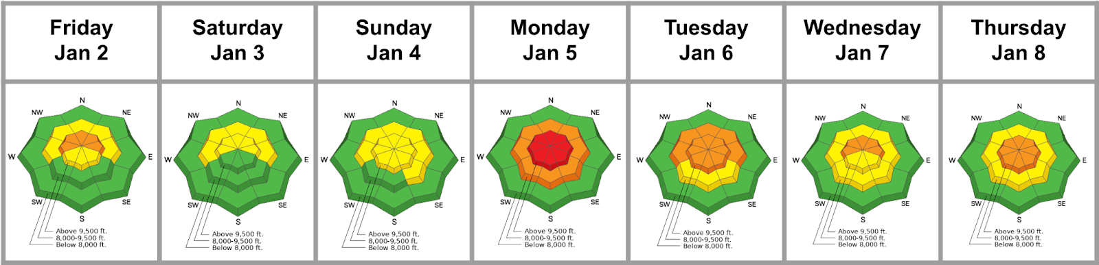
Summary: A series of small storms give way to larger storm totals, and all of a sudden—winter is on! A wild amount of avalanches, close calls, and new snow(!) throughout the week. A series of storms start out wet and dense before giving way to the classic cold smoke we’ve all been waiting for. Unfortunately, multiple avalanche involvements and textbook close calls litter the observation page as well. Most notably, a snowmobiler was buried save his hand—and luckily was rescued by his party with minimal injury. Danger spikes on Tuesday as upper elevations spike to HIGH before returning to CONSIDERABLE for the rest of the week
Friday (1/2): A continuation of the wet snow that fell the day before, with storm totals favoring Upper Little Cottonwood Canyon, reaching 3–13 inches of snow with 0.50–1.85 inches of water by the time we were drinking our coffee. SW winds continued to build wind drifts as a modest amount of new snow falls before tapering off in the evening. Forecasters are grateful to a public observer for reporting being involved in a slab avalanche running on the persistent weak layer at the ground on the same slope in Hidden Canyon—in the backcountry adjacent to Brighton— where a similar slide ran on just days earlier. Northerly, steep, rocky, and wind-exposed slopes continue to be the epicenter of instability.
Saturday (1/3): The final storm totals clock in at 15 inches of the fresh and fluffy with 2 inches of water for the good patrons of upper Little Cottonwood, with less favored areas picking up a boot-top refresh of 6-7 inches of snow with some rain. The trailheads are packed extra early, and people sat in traffic en route to their long-awaited face shots. Forecasters don’t rest easy knowing the powder will make the spatial variability of the CERC (Christmas Eve Rain Crust)—the supportability of which allows for riders to trigger the PWL—hard to remember when standing atop slopes. The SW winds rip, throughout the day, keeping both ski areas and backcountry travelers on their toes, with a natural wind slab running in steep east-facing terrain near 11,000' in upper LCC and another well off ridgeline in White Pine at 9900'. UAC Forecaster Drew Hardesty heads to Brighton to take a look at the second Hidden Canyon avalanche that ran the day prior, when he and Brighton Snow Safety Director Malia Bowman happen upon a third avalanche on the same slope in Hidden Canyon. Based upon the investigation of Brighton Ski Patrol, it appears that two riders were caught and carried earlier that day, with one partial and one full burial. Most likely, the party exited the ski area boundary and entered the dangerous terrain, triggering the 2-4 foot deep and 200 foot wide avalanche, and were pummeled for 500' down the slope. They were very lucky.

Sunday(1/4): After turning off overnight, the SW winds ramp back up as a weather system moves in, with the bulk of the precipitation falling in the early evening through to the next day. Cold temps and fresh snow from days prior continue to build hefty wind slabs and cornices at higher elevations. A group touring along the ridge above Two Dogs in Days Fork unintentionally releases a cornice onto the slope below, which triggers an avalanche that initially fails above the Christmas Eve rain crust (CERC) layer, but steps down to facets and depth hoar at the ground. The slide is on a northeast-facing slope at 10,100 feet and is 4.5 feet deep, 250 feet wide, and runs 700 feet, snapping trees along the way. This was a notable avalanche, as it demonstrates that the weak snow below the CERC can still be triggered. More cold snow continues to fall and load the snowpack overnight, with sustained SW winds blowing at perfect loading speeds—the perfect setup for some fresh wind slabs to build.

Monday (1/5): Winter is back in full swing, and so are avalanches. Danger jumps to HIGH at upper elevations with the load of new snow overnight into the day. News rolls in from Brighton Snow Safety of a 4th(!) skier getting caught, carried, and partially buried in an avalanche in Hidden Canyon within the week. Luckily, no injuries are reported, but the debris is up to 15’ deep in some areas. Talk about some luck. Reports of natural large avalanches abound, from the Superior Apron to Sunset Peak. The forecast team decides to issue a Special Avalanche Bulletin at 3 PM: a product we use when dangerous avalanche conditions exist, and there are circumstances that may make folks more likely to get into an accident than usual….like the first real storm of the season, on top of a highly variable PWL, after a lackluster start to the season. We’re powderhounds too, and we’ve been starved for too long. Then, a kicker of an observation comes in in the evening: a group of snowmobilers near Lavina Creek trigger a large avalanche near First Cornice that catches, carries, and buries one of the riders. Luckily, the team carried rescue gear and was able to get the rider and their machine out with minimal damage. No shortage of avalanches or luck this day. With reported dimensions quite large, the forecast team makes plans to investigate the slide the next day. Big thanks to the riders for reporting this slide very openly and honestly.

Tuesday (1/6): The danger drops back down to CONSIDERABLE, but the Special Avalanche Bulletin continues through the day as bluebird skies and stacks of fresh snow draw skiers and riders out of the woodworks—many for the first time this season. Storm totals as of 5 AM are close to 30 inches in favored areas, with up to 3.84 inches of water. UAC forecasters head out to First Cornice and find a D2.5 R3 hard wind slab avalanche that ran above the CERC, averaging 4-5 feet deep, with the max depth nearing 7 feet. Blocks in the debris were as large as small cars and would certainly win in a fight. As the skies clear, more large natural avalanches are reported, including one in Oingo Boingo that ran at the ground below the CERC on the PWL. Excellent riding conditions are reported as well on lower-angle slopes. Instant winter is back in the Wasatch, with soft light snow to match. We’ll take it.
First Cornice Close Call 01/05/2026
Wednesday (1/7): The Special Avalanche Bulletin expires, as avalanche danger drops to MODERATE on most slopes, with a pocket of CONSIDERABLE at upper elevations on W-N-E slopes. Another cold, traditional storm puts its wheels down in the central Wasatch in the early afternoon. Observers report lots of graupel, as well as our dear, cold storm friends: stellar dendrites. Skiing and riding conditions on lower-angled slopes continue to be, well…stellar. Explosive control work (Wyssen exploders) in upper LCC trigger a large hard slab into old weak faceted snow on a steep northeast facing slope at 10,600 feet. This avalanche then sympathetically triggered another, similar, avalanche adjacent to it that also failed in the old faceted snow. These are described as size D2.5-3, which means big enough to bury and destroy a car, a wood frame house, or break a few trees. More evidence that the PWL below the CERC is not something to be put to bed yet. In total, 6 inches of snow falls, along with 0.40 inches snow water equivalent, by the next morning.

Thursday (1/8): Another cold storm wraps up with another 13.5 inches of snow and .9 inches of water in favored areas. Easy to initiate dry loose and wind slabs are reported throughout the backcountry and at resorts. Fluffy, white, fresh is out there, as are significant instabilities. The forecast team discusses how to manage the intersection of fresh new snow, significant instabilities, an incoming bluebird weekend, and lots of powder hungry Wasatch skiers.




