
Summary: We were still reeling from the Grinch storm on Christmas Eve, which brought an inch of rain to nearly all elevations, with an inch of snow to show for it at higher elevations. Rain crusts caked the Wasatch, with lenses one to three inches thick. Not to be counted out, Santa finally arrived on a cold front Friday night..with storm totals of 6-12” of low density snow by early Sunday morning. The cold smoke sluffed easily on the bullet-hard crusts, but forecasters were still wary of the old PWL of facets buried 2-3’ deep. As proof of concept, a skier on Sunday triggers a hard slab that steps to this PWL in the Alta-Brighton backcountry on Sunset Peak, 2-3’ deep and 80’ wide. The overall danger was MODERATE for much of the week, with the primary concerns revolving around loose dry, loose wet, pockety wind slabs and the low probability - low consequence hard slab failing on the PWL. Another avalanche stepped to the ground likely on Tuesday in Hidden Canyon in the Brighton backcountry. Late week, a warm and wet storm impacted the state on New Year’s Day, bringing rain (again) to near 9000' and about 6" at the higher elevations.
Friday: A transitional day between an Atmospheric River event that brought rain on Christmas Eve to all elevations….and an expected two-pronged cold front to bring winter back to the Wasatch Friday night into Saturday. Astonishingly, no significant avalanches were reported Thursday into Thursday night, but for some wet loose sluffs when the rain touched the cold snow on high northerly terrain. Forecasters still worry about the basal facets, and the rain crust has only complicated matters. Both localized and wider-propagating collapses are noted by the few touring parties out and about.
Saturday: Despite being late, Santa delivered the goods. The Central Wasatch picked up 6-12” of snow and up to an inch of snow-water-equivalent. (Forecasters rejoice that they can finally use SWE instead of rain or liquid precipitation.) Off and on snowfall during the day. Few people were out and about in the backcountry, but those who toured described easy sluffing of the cold smoke on the rain crusts. Longer-running natural sluffs were noted on Superior that ran to the apron. Trent’s video along the PC ridgeline continues to demonstrate a poor structure and reactive facets at the base of the snowpack.
Sunday: Sunday dawns clear with a few crystals of snow lingering from the departing clouds. The Wasatch regains some of its legendary form: top-shelf powder skiing and riding, a crowded backcountry of hungry enthusiasts who have endured one of the worst seasons on record, and more than a couple of catch-and-carrys, as well as a very close call involving the PWL. Two skiers are simultaneously caught and carried in parallel Toledo Chutes: one in a dry sluff, the other in a sluff that subsequently triggered a more widely propagating soft slab. Both came out mostly unscathed. Another skier is caught and carried in a sluff on Little Superior. The rain crust is an ice rink - when people start sliding, they have a difficult time arresting or coming to a stop.
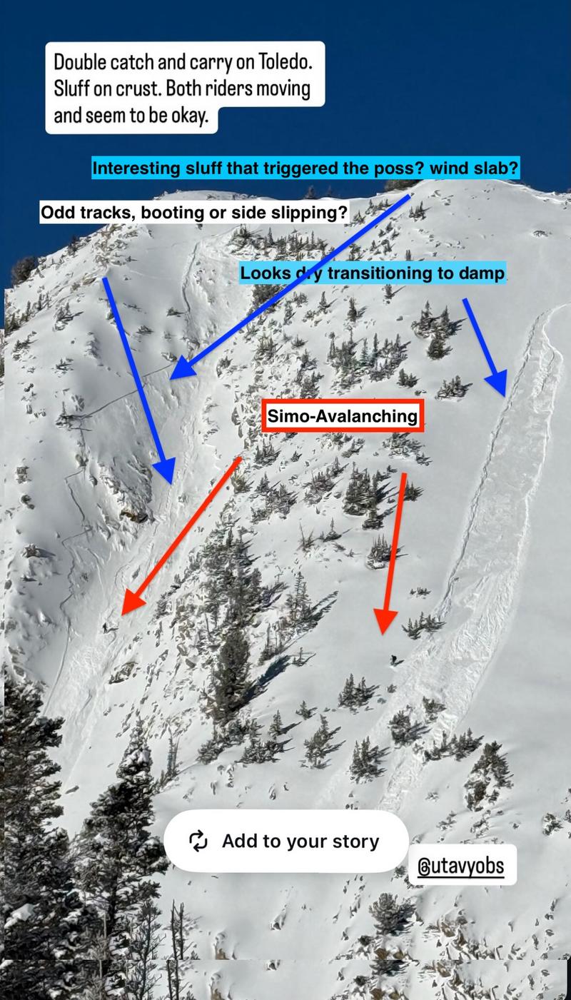
Two skiers trigger, and are caught and carried in Toledo Chute and main Toledo on Sunday
Not an hour later, a skier triggered a hard slab avalanche to the ground in the steep north-facing terrain of Sunset Peak. He was not caught…but this avalanche finally confirms, or gives proof of concept, to the ‘worry’ that one could trigger an avalanche through not one but two crusts (an upper rain crust and a lower thermal crust) down to the basal facets. This avalanche registered as 2-3 feet deep and 80 feet wide. Snowbird reports a natural hard slab pocket early Sunday morning (pre-dawn) in upper Pipeline Bowl beneath the Twin, and explosive testing triggers two more pockets down to the old faceted snow in similar terrain.
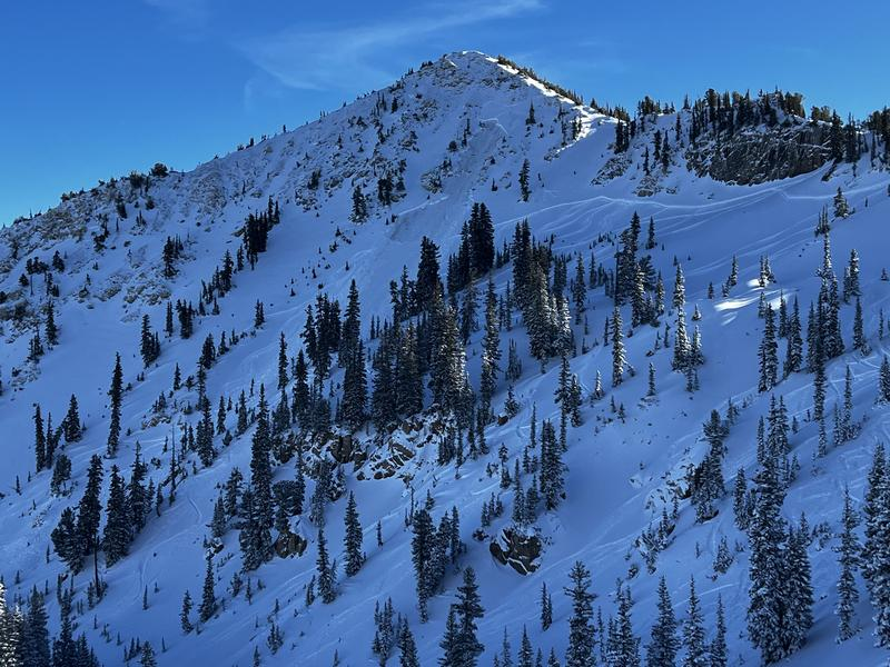
Skier triggered avalanche to the ground on Sunset Peak on Sunday
Monday: Temps start cool, but rapid warming ensues. The cold, dry snow becomes damp to wet with sunny skies and another skier is caught and carried on south-facing Two Trees (steep south-facing terrain east of Superior) and passersby observe a wet loose “waterfall’ cascading over the Hellgate cliffs across from Snowbird. Dave Kelly's report on the Sunset Peak avalanche is HERE>
Tuesday: Warmth continues as mountain temperatures reach 44°F at the Alta Guard Station (8799’) with more warmth expected on Wednesday. Some minor wet loose sluffing is noted on steep solar aspects. In a non avalanche related incident, a backcountry skier slipped while skinning the ridge from Cardiff Pass toward Cardiff Peak. The slip resulted in an uncontrolled slide for life, carrying him north over the cliff bands and into Cardiff Bowl. Salt Lake County Search and Rescue, Wasatch Backcountry Rescue, DPS, Unified Fire, Life Flight, and Powderbird responded, and the injured skier was air evacuated to the valley by helicopter. This incident highlights the real world impact of the Christmas Eve rain crust on current backcountry conditions. It’s worth noting that two skiers caught and carried in loose snow avalanches on Sunday also reported losing their edge on the same slick crust interface, reinforcing how consequential these crusts have become for both avalanche behavior and general travel in steep terrain.
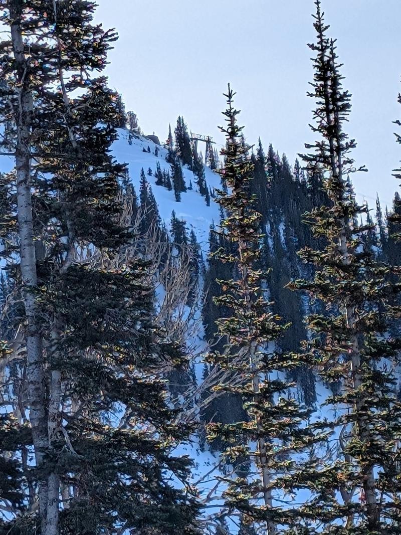
Avalanche to the ground in Hidden Canyon, adjacent to Brighton ski resort. Likely remotely triggered by a rider on Tuesday; details unknown
Wednesday: Warmer temperatures in the mountains. All eyes are on the upcoming storm, due to impact the state Thursday through Friday. This storm, too, looks to be warm and wet with rain-snow lines to 8500’. A late report received Wednesday describes a likely skier triggered avalanche in upper Hidden Canyon. The slide clearly failed to the ground in steep, north facing, rocky terrain at 10,350’. Estimated dimensions are 2 to 3’ deep and 50’ wide. While details remain limited, the photo confirms a full depth, ground reaching fracture.
Thursday: We wake up to an inch of wet snow at 8000’. The rain-snow line hovers around 8500’...with precipitation continuing for most of the day…..The central Wasatch picked up just 4-6" of soggy dense snow. Forecaster Brooke Maushund's report in Hidden Canyon is HERE.
- reply


