
Nikki Champion
Forecaster
Week in Review: Avalanche Conditions and Snowpack Developments (January 10th - January 16th, 2025)
Each week, we look back at the key snowfall, weather, and avalanche events from the previous week. For archived forecasts, visit the Salt Lake Mountains’ past updates HERE.

Overall Summary:
This week featured a variety of avalanche conditions in the Wasatch, beginning with CONSIDERABLE danger at mid and upper elevations due to a weak snowpack structure and large wind slabs. A significant storm on Saturday brought 12–22 inches of snow (0.50–1.26" SWE) to the Upper Cottonwoods, 5–8 inches (0.50–0.80" SWE) to the Park City Ridgeline, and 5 inches to lower elevations of Lambs Canyon and Parleys, maintaining the CONSIDERABLE danger level. As the storm tapered off, the danger dropped to MODERATE, but risks remained significant, especially in thin, rocky areas and on "repeater" slopes.
This week featured a variety of avalanche conditions in the Wasatch, beginning with CONSIDERABLE danger at mid and upper elevations due to a weak snowpack structure and large wind slabs. A significant storm on Saturday brought 12–22 inches of snow (0.50–1.26" SWE) to the Upper Cottonwoods, 5–8 inches (0.50–0.80" SWE) to the Park City Ridgeline, and 5 inches to lower elevations of Lambs Canyon and Parleys, maintaining the CONSIDERABLE danger level. As the storm tapered off, the danger dropped to MODERATE, but risks remained significant, especially in thin, rocky areas and on "repeater" slopes.
On Monday, a skier triggered a persistent weak layer (PWL) avalanche in Butler Basin, resulting in a partial burial. On Wednesday, a ski party remotely triggered a significant avalanche in the Hallway Couloir, highlighting the ongoing risk from buried weak layers even in more remote terrain. Solar slopes saw wet-loose avalanches throughout the week, and while overall danger decreased, the low-likelihood but high-consequence scenario persisted.
Friday, January 10
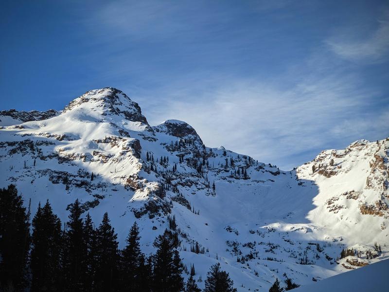
Danger remained CONSIDERABLE at mid and upper elevations. Sunshine briefly returned before another weekend storm. Observers reported a weak snowpack structure, including a natural hard slab avalanche in the Mill B South area of Big Cottonwood Canyon on a northeast-facing slope at 9,800', with a slope angle of 37°. This avalanche, failing on a persistent weak layer, measured 3.5 feet deep, 300 feet wide, and ran 400 vertical feet. A soft slab avalanche occurred on a north-facing slope at 8,900' in Mineral Fork, measuring 3 feet deep, 70 feet wide, and running 400 vertical feet. Both avalanches failed on the PWL. In the Session Mountains, two recent avalanches were observed: a wind slab and one involving weak faceted snow. Wet-loose avalanches also occurred on steep, south-facing terrain in Tanners Gulch.
Danger remained CONSIDERABLE at mid and upper elevations. Sunshine briefly returned before another weekend storm. Observers reported a weak snowpack structure, including a natural hard slab avalanche in the Mill B South area of Big Cottonwood Canyon on a northeast-facing slope at 9,800', with a slope angle of 37°. This avalanche, failing on a persistent weak layer, measured 3.5 feet deep, 300 feet wide, and ran 400 vertical feet. A soft slab avalanche occurred on a north-facing slope at 8,900' in Mineral Fork, measuring 3 feet deep, 70 feet wide, and running 400 vertical feet. Both avalanches failed on the PWL. In the Session Mountains, two recent avalanches were observed: a wind slab and one involving weak faceted snow. Wet-loose avalanches also occurred on steep, south-facing terrain in Tanners Gulch.
The large avalanche in Mill B South - NE Aspect - 9800'
Saturday, January 11
An impressive, fast-moving storm delivered 12–22 inches of snow (0.50–1.26" SWE) to the Upper Cottonwoods, 5–8 inches (0.50–0.80" SWE) along the Park City Ridgeline, and 5 inches at lower elevations in Lambs Canyon and Parleys, driven by a strong northwest flow. Avalanche danger remained CONSIDERABLE at mid and upper elevations due to fresh snow and significant wind drifting. Ski areas reported sensitive soft slabs up to 18" deep, with explosive tests triggering avalanches up to size 2. Dry-loose avalanches were also observed, running fast and far in steep terrain.
An impressive, fast-moving storm delivered 12–22 inches of snow (0.50–1.26" SWE) to the Upper Cottonwoods, 5–8 inches (0.50–0.80" SWE) along the Park City Ridgeline, and 5 inches at lower elevations in Lambs Canyon and Parleys, driven by a strong northwest flow. Avalanche danger remained CONSIDERABLE at mid and upper elevations due to fresh snow and significant wind drifting. Ski areas reported sensitive soft slabs up to 18" deep, with explosive tests triggering avalanches up to size 2. Dry-loose avalanches were also observed, running fast and far in steep terrain.
Sunday, January 12
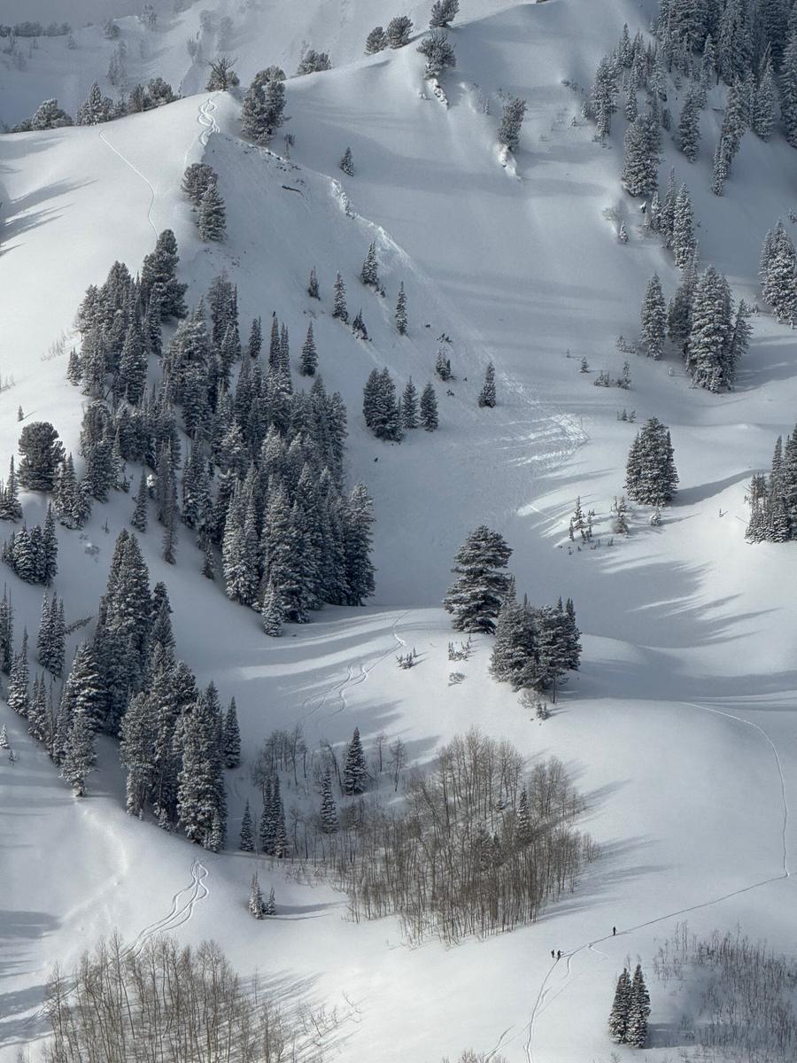
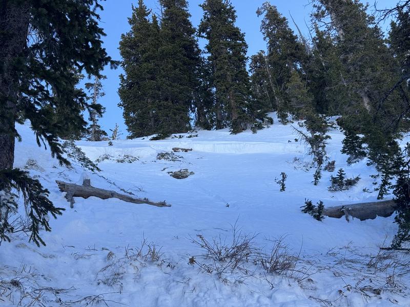
CONSIDERABLE avalanche danger extended to all aspects at upper and mid-elevations, driven by new and wind-drifted snow and the persistent weak layer on northerly aspects. The third skier on a slope triggered an avalanche that failed on the PWL on a north-facing slope at 9,000 feet in Butler Basin, resulting in a partial burial, leaving only the skier's head and arm above the surface.
CONSIDERABLE avalanche danger extended to all aspects at upper and mid-elevations, driven by new and wind-drifted snow and the persistent weak layer on northerly aspects. The third skier on a slope triggered an avalanche that failed on the PWL on a north-facing slope at 9,000 feet in Butler Basin, resulting in a partial burial, leaving only the skier's head and arm above the surface.
The skier triggered avalanche in Butler Basin - N aspect - 9000'
Monday, January 13
As the storm cycle tapered off, avalanche danger decreased to MODERATE at mid and upper elevations, though the consequences of triggering an avalanche remained significant. Two glide avalanches were reported in upper Broads Fork—one on Monday and another likely a few days old.
As the storm cycle tapered off, avalanche danger decreased to MODERATE at mid and upper elevations, though the consequences of triggering an avalanche remained significant. Two glide avalanches were reported in upper Broads Fork—one on Monday and another likely a few days old.
Tuesday, January 14
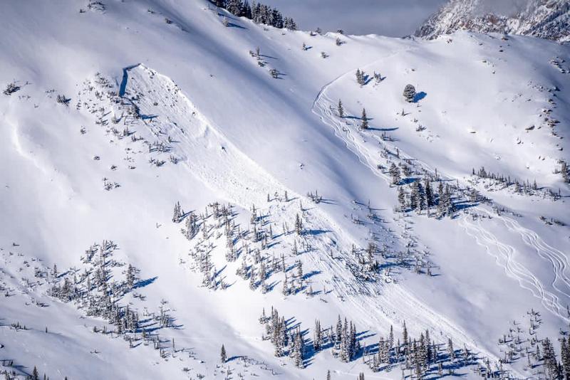
The danger remained MODERATE as temperatures dropped significantly. The PWL persisted on west, north, and east aspects, with higher risks in thin, rocky areas and "repeater" slopes. A remotely triggered hard slab avalanche occurred in the High Ivory area of Cardiff Fork on an east-facing slope at 10,000', measuring 3 feet deep and 200 feet wide. The avalanche, failing on the PWL, was triggered from 150 feet away. Wet-loose avalanches were also reported.
The danger remained MODERATE as temperatures dropped significantly. The PWL persisted on west, north, and east aspects, with higher risks in thin, rocky areas and "repeater" slopes. A remotely triggered hard slab avalanche occurred in the High Ivory area of Cardiff Fork on an east-facing slope at 10,000', measuring 3 feet deep and 200 feet wide. The avalanche, failing on the PWL, was triggered from 150 feet away. Wet-loose avalanches were also reported.
The remotely triggered avalanche from High Ivory - 150' away - E aspect - 10,000'
Wednesday, January 15
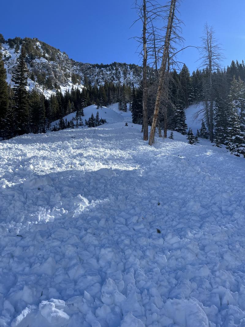
With significant sun exposure, danger rose to MODERATE on solar aspects. A ski party remotely triggered a significant avalanche in the Hallway Couloir, measuring 2–3 feet deep and 70 feet wide, failing on the PWL. The avalanche, triggered on a steep northwest-facing slope at 10,400', ran a long distance into the Tube in Cardiff Fork, Big Cottonwood Canyon.
With significant sun exposure, danger rose to MODERATE on solar aspects. A ski party remotely triggered a significant avalanche in the Hallway Couloir, measuring 2–3 feet deep and 70 feet wide, failing on the PWL. The avalanche, triggered on a steep northwest-facing slope at 10,400', ran a long distance into the Tube in Cardiff Fork, Big Cottonwood Canyon.
The substantial debris pile from the Hallway avalanche - NW facing aspect at 10,400' - photo from below in Big Cottonwood Canyon
Thursday, January 16
The danger remained MODERATE at mid and upper elevations and on solar aspects where solar slopes continued shedding wet sluffs, producing deep debris piles. A skier-triggered avalanche failing in the PWL along the Pioneer Ridgeline in upper Big Cottonwood Canyon. The avalanche was 2' deep and 30' wide and the rider was caught and carried, but deployed their airbag and ended up on top of the debris with no injuries.
The danger remained MODERATE at mid and upper elevations and on solar aspects where solar slopes continued shedding wet sluffs, producing deep debris piles. A skier-triggered avalanche failing in the PWL along the Pioneer Ridgeline in upper Big Cottonwood Canyon. The avalanche was 2' deep and 30' wide and the rider was caught and carried, but deployed their airbag and ended up on top of the debris with no injuries.
Thanks Nikki!
Edo (not verified)
Sun, 1/19/2025
- reply


