25th Annual Black Diamond Fall Fundraising Party
Thursday, September 13; 6:00-10:00 PM; Black Diamond Parking Lot
25th Annual Black Diamond Fall Fundraising Party
Thursday, September 13; 6:00-10:00 PM; Black Diamond Parking Lot
| Advisory: Uintas Area Mountains | Issued by Craig Gordon for Saturday - December 24, 2016 - 4:17am |
|---|

|
bottom line Heads up... it'll be a day of rising avalanche danger. At mid and upper elevations, particularly in the wind zone, the avalanche danger is MODERATE this morning. Human triggered avalanches are POSSIBLE, especially on steep, wind drifted slopes facing the north half of the compass. Once triggered, today's avalanches have the potential to break deeper and wider than you might expect. As the storm gels together expect the avalanche hazard to rise accordingly. The danger could reach CONSIDERABLE and human triggered avalanches become PROBABLE in this same type of terrain by days end. Low elevation wind sheltered terrain and most south facing slopes offer generally LOW avalanche danger.
|
 |
special announcement Looking for a last minute stocking stuffer? Give the gift that keeps giving and help save a life by doing so. Sign up for one of our Riding Skills and Avy Awareness Workshops given by sledders... for sledders. We've got two workshops this year- Thursday Jan 19th evening, followed by an on the snow field day Saturday Jan. 21st. Details here. Thursday Feb. 9th evening, followed by an on the snow field day Saturday Feb. 11th. Details here. |
 |
current conditions Last night's quick hitter left 3" of snow on the south half of the range, while just laying down an inch or so on the North Slope. Southerly winds however didn't discriminate and they've been blowing in the 30's and 40's since late yesterday afternoon. Currently, under mostly cloudy skies, light snow is falling and temperatures are in the mid teens and low 20's. Riding and turning conditions remain quite good especially on wind sheltered slopes, where you'll continue to find cold, creamy snow on a mostly supportable base. Real time wind, snow, and temperatures for the Uinta's are found here. Recent observations are found here.
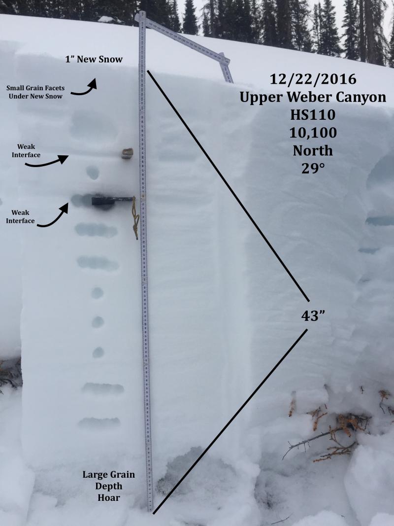
JG was in Upper Weber Canyon and found stable snow, though he has a few concerns with weakening surface snow and deeper buried issues in the pack. His take on things is found here.
Over near Duke Ridge, MJ was finding a similar snow structure. We all seem to be on the same page and his viewpoint is found here. |
 |
recent activity No news of the weird from our hood... meanwhile in the Wasatch though.
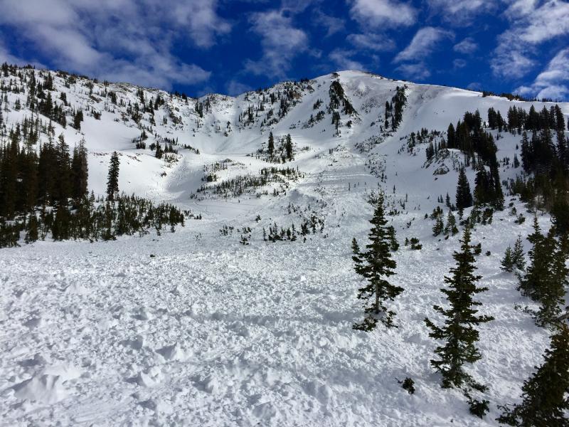
Looks like a Uinta avalanche doesn't it? Two extremely lucky riders came out on top after a very close call in Little Cottonwood Canyon late Monday. (M. Staples photo) A brilliant write up is found here. A full list of recent Uinta avalanche activity is found here. |
| type | aspect/elevation | characteristics |
|---|

|
|
LIKELIHOOD
 LIKELY
UNLIKELY
SIZE
 LARGE
SMALL
TREND
 INCREASING DANGER
SAME
DECREASING DANGER
|
|
description
Winds are going to be cranking along the ridges and I wouldn't be too surprised to see them getting down into mid elevation terrain as well. With a little snow to work with this morning and more expected as the storm materializes, I suspect fresh drifts or what we call wind slabs, are gonna form all over the place today and become more reactive to our additional weight as the day wares on. The good news is... they're pretty straight-forward and easy to detect by their fat, rounded appearance. Found along the leeward side of upper elevation ridges and around terrain features like chutes, gullies, and sub-ridges, this mornings shallow wind slabs are generally manageable, predictably breaking at or below your skis, board, or sled. However, once the storm kicks into gear, avalanche conditions will change accordingly. With more wind and snow in the forecast, I'm thinking the slabs will become more connected and may break deeper and wider than you might expect, particularly towards the end of the day. |
| type | aspect/elevation | characteristics |
|---|

|

|
LIKELIHOOD
 LIKELY
UNLIKELY
SIZE
 LARGE
SMALL
TREND
INCREASING DANGER
SAME
DECREASING DANGER
|
|
description
No reports of the weird in this department, but I bet there's a pocket or two still lurking out there that just needs a little coaxing. Once it fails... all bets are off. Found mostly on steep, rocky, upper elevation slopes facing the north half of the compass, todays slabs may be harder to initiate, but once triggered, have the potential to break into weak layers now buried deep in our snowpack. |
 |
weather A nice looking storm is on our door step. Widespread snow develops later toady along with very strong southerly winds nuking into the 60's and 70's along the high ridges. High temperatures reach into the upper 20's and a foot of snow by about dinner time seems like a reasonable bet. Winds diminish this evening with the arrival of the cold front. The south half of the range does well through midnight tonight, but once the flow turns west-northwest the North Slope catches up. In either case storm totals should be close to 18". |
| general announcements Remember your information can save lives. If you see anything we should know about, please participate in the creation of our own community avalanche advisory by submitting snow and avalanche conditions. You can call me directly at 801-231-2170, email [email protected] The information in this advisory is from the US Forest Service which is solely responsible for its content. This advisory describes general avalanche conditions and local variations always occur. The information in this advisory expires 24 hours after the date and time posted, but will be updated by 7:00 AM on Sunday December 25th. |