
Text below from a member of the party involved:
"We were finishing up a full day tour and decided to drop into birthday chutes to get back to White Pine Trailhead. We had been on all aspects during the day and the only red flags we saw were warming on the south slopes and some wind loading mostly on east faces. The top of the northwest side of the Red Top Mountain was scoured and cornices were formed on the east side of Temptation Ridge. We saw no signs of wind loading into Birthday Chutes so we decided to drop in. The snow surface was very soft and seemed safe. After my partner rode the top couple hundred feet, he moved over close to the trees on the skiers left of the chute. As I started forward into the chute I saw snow start moving slowly about 2 feet in front of my board. I immediately dove back and grabbed a small tree. The slide picked up a ton of speed and propagated way farther west than I thought possible. The crown broke all the way to the ground from the top. The slide went all the way to the hill on the west side of Columbine Bowl where a couple hundred foot cloud of snow shot into the air. I immediately radioed my partner but the radio kept shutting off due the the cold. I tried calling him but his phone was off, I could not find a safe route to the debris pile so I called 911 and asked for rescue crews.My partner was able to dig out his feet and call 911."
Forecaster notes:
Weather and Snow information:
From December 14 to December 16, the Alta Guard Station 3 miles NNE of the avalanche site, received snow containing 2.5 inches of snow water equivalent. On Thursday, December 15 and Friday, December 16 winds at 11,000 feet averaged 31 mph and gusted 47-62 mph from the southwest. By late Dec 16, winds at 11,000 feet were averaging 50 mph gusting to 75 mph from the WNW. Those winds were a significant factor in this avalanche for two reasons:
First, winds easily doubled the load on this slope with wind-blown snow adding significant stress to faceted snow at the ground. Faceted snow is very tricky. It can support a tremendous load without fracturing and producing an avalanche. However, as soon as a very small crack or failure is started, it can quickly fracture across the entire slope. The snowboarder who triggered this avalanche likely rode over a thin spot of the slab where he initiated a crack in the faceted snow layer which fractured and released the slab.
Second, winds built a slab that connected across both chutes. This stiff, cohesive slab is what helped carry the fracture across both chutes and fracture over such a wide area.
Snow that formed the weak layer in this avalanche fell in the fall and was preserved on this slope because of the high elevation and northerly aspect while snow melted off other slopes. This snow metamorphosed and became weak, faceted snow crystals. See the photo below from video footage taken on November 14, 2016. Notice that other aspects exposed to more sun did not have snow on the ground.
Avalanche information:
This party had been reading the avalanche advisory for most of the season. On the day of the avalanche, they had been looking for signs of instability during their tour in Mineral Basin, in Mary Ellen Gulch, over Silver Creek Peak, over American Fork Twin Peaks, and over Red Top Mountain. They noted warming on south aspects and were carefully monitoring wind speeds and direction. Winds were relatively light in the Birthday Chutes and not depositing snow at the time. Unfortunately it was winds on Thursday, December 15 and Friday, December 16 that heavily loaded this slope.
The image below (photo by M. White) shows the approximate location of the two people. One person was at the black X and was not caught in the avalanche. The person who was caught in this avalanche had traveled the path of the red line and was caught in the slide at the location of the red X. He initially made 3 or 4 turns, thought he heard something, began traversing to the looker’s right, and made 5 or 6 turns before the avalanche broke. He never saw the avalanche coming and said that it felt like he was hit by a freight train. The person on top of the ridge had to jump back to avoid being caught. He commented that the avalanche did not make any noise when it fractured and seemed to pull away very slowly for the first 50 feet before accelerating.
This avalanche was approximately 730 feet wide, 4-5 feet deep on average with a minimum of 3 feet and a maximum of 10 feet deep. It ran 1,100 feet vertical. U.S. classification is HS-AR-R3-D3-G

Rescue:
This avalanche occurred at about 5 p.m. Once the avalanche happened, this party was in a very difficult situation especially with the fading daylight. They both had radios with dead batteries from being on all day, thus they were not able to communicate. They could not see each other either. Both feared that the other had been caught and was buried.
The person on top of the ridge was unsure he could descend safely to his partner whom he thought was dead. Because of the late hour and what he thought was an unsafe situation, he decided to call 911. He was on top of the ridge for about an hour and a half in the dark. When his phone battery died, he finally descended a ridge and the White Pine drainage ultimately reaching the White Pine trailhead. The whole time he thought his partner was buried and dead. It wasn't until reaching the parking lot and talking with Search and Rescue personnel that he discovered his partner was alive.
The person caught in the avalanche survived and amazingly was not injured. When the avalanche stopped, he was on top of the debris only buried to his knees with his face down. As he looked up, he saw a powder cloud of airborne snow roll over top of him. Because he and his partner had not explicitly discussed a plan for riding this chute, he assumed the worst. Also, he was unable to communicate with his partner due to dead radio batteries and figured his partner was buried. He also contacted 911. For the next hour and a half he searched the debris field with an avalanche transceiver. Ultimately a helicopter was sent to the scene and transported him to Alta.
Forecaster comments:
On the day of the avalanche the danger was rated Moderate at this elevation. The avalanche problems listed in that day's advisory were Loose Dry avalanches, Loose Wet avalanches, and Storm Snow avalanches.
This was a difficult situation for all involved including Search and Rescue who received two separate calls from someone stating that their partner was buried in an avalanche. Sorting the details in these events can be very difficult. For the two people involved, it was also a very difficult and confusing situation as well. This event highlights how difficult avalanche rescue can be and that many events can happen at the end of the day in darkness. Luckily no one was buried. This emphasizes the need to practice companion rescue skills and be familiar with terrain because many avalanches occur under difficult conditions. If you are in unfamilar terrain, that can be an additional risk factor.
Deep slab avalanches are by far the most difficult avalanche problem to deal with. Even professional operations armed with explosives struggle with these types of avalanches. Because the weak layer is buried deeply under a thick, hard slab of snow, impacting the weak layer with enough force to trigger an avalanche is not easy to do. There’s a decent chance this party could have descended the chute without triggering this avalanche.
Information from this report comes from a visit to the avalanche by Mark Staples, Greg Gagne, Mark White and 2 members of the Snowbird Ski Patrol on December 20, 2016 as well as a phone interview with the two people involved in the avalanche. This report was compiled by Mark Staples with help from other UAC staff.
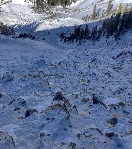
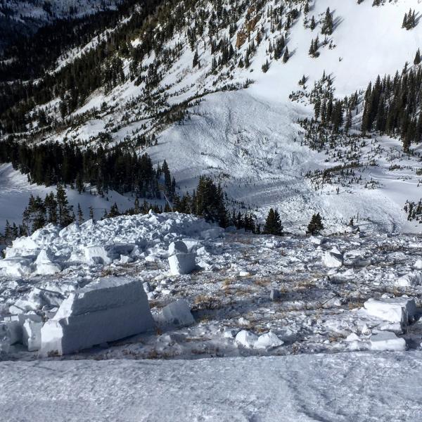
Images below taken by the Utah Avalanche Center.
1. View of Birthday Chutes looking west from the Snowbird Ski Area
2. View up from the huge debris field
3. The avalanche broke on old facets at the ground. Crown depth averaged 4-5 feet with a maximum of 10 feet and minimum of 3 feet. It was 730 feet wide and ran 1,100 feet vertical.
4. Close up view of the snow crystals that made up the weak layer. They were 1 mm in size.


Photos below taken by M. White. The last photo is of the the snowpit we dug while approaching the avalanche and was graphed in the profile below.
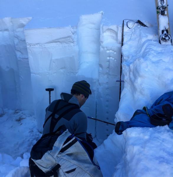
Profile of the snowpack on a similar aspect at 10,100 feet.

Photo from Nov 14, 2016 showing old snow that became the weak layer. Photo from video footage by Tony Pavlantos and Steve Lloyd. Red line is a rough approximation of the crown location.


