| Please join us at the 23rd annual Black Diamond Fall Fundraiser Party Thursday Sept 15. Tickets are on sale now here, at the Black Diamond store & at REI. Special bonus raffle for online ticket purchasers! |
| Please join us at the 23rd annual Black Diamond Fall Fundraiser Party Thursday Sept 15. Tickets are on sale now here, at the Black Diamond store & at REI. Special bonus raffle for online ticket purchasers! |
| Advisory: Uintas Area Mountains | Issued by Craig Gordon for Tuesday - March 22, 2016 - 4:29am |
|---|

|
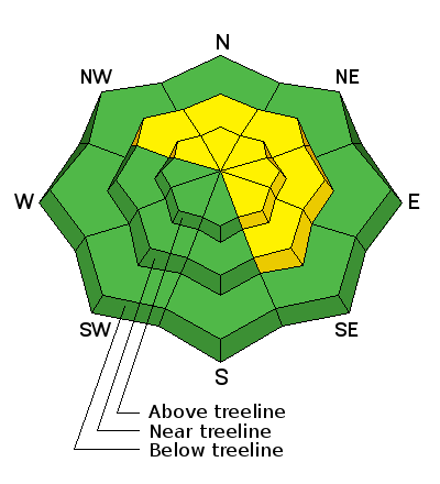
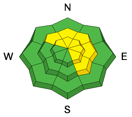
bottom line In the wind zone, at and above treeline, the avalanche danger will rise to MODERATE as the storm develops. Human triggered avalanches will become possible on steep, wind drifted slopes, especially those that face the north half of the compass. Any slide that breaks to old snow near the ground has the potential to break deeper and wider than you might expect and can quickly ruin your day. Out of the wind the avalanche danger is generally LOW.
|
 |
special announcement Please help guide our discussions of website maintenance, upgrades or possible changes in coming years. Take this brief survey. As a way of saying thanks we'll be raffling a free avalanche class and other free stuff like hats, beanies, water bottles, etc. |
 |
current conditions Under a thick blanket of clouds, overnight low temperatures only dipped into the upper 20's and mid 30's, where the mercury still sits early this morning. Southwest winds bumped up slightly in the past few hours and are blowing 40-60 mph along the high peaks. Until we stack up a little new snow it's gonna be a bit rugged out there. Might be a good morning to work on the taxes and get after it this afternoon.
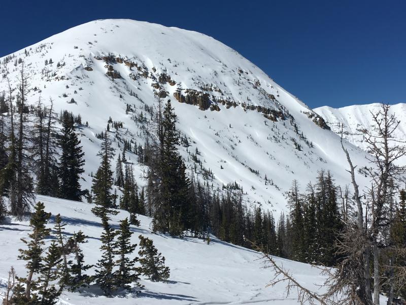
It's been a great few days in the Uinta mountains with plenty of sunshine and powder snow. (Photo: Mirror Lake area) Uinta weather station network info is found here. Trip reports and observations are found here.
|
 |
recent activity No new avalanche activity was reported from the Uinta backcountry yesterday. Check out this close call from the Logan area mountains. Forecasters Toby & Paige Weed put together the accident report found here their video is below. Recent avalanche observations are found here See or trigger an avalanche? Shooting cracks? Hear a collapse? It's simple. Go here to fill out an observation.
|
| type | aspect/elevation | characteristics |
|---|

|
|
LIKELIHOOD
 LIKELY
UNLIKELY
SIZE
 LARGE
SMALL
TREND
 INCREASING DANGER
SAME
DECREASING DANGER
|
|
description
As new snow starts stacking up and winds continue to crank, expect the avalanche danger to rise accordingly. With heavy snowfall in the forecast, I suspect fresh wind drifts will become deeper, more widespread, and more sensitive to the weight of a rider, especially as the storm starts to materialize. Found mostly on steep, upper elevation, leeward terrain, look for and avoid any fat, rounded piece of snow, particularly if it sounds hollow like a drum. Don't forget- shallow snowpack areas exist and there is still a chance of triggering an avalanche that breaks to old, weak snow. Steep, upper elevation, north facing slopes, especially those with a thin, weak snowpack need to be carefully evaluated or better yet, simply avoid terrain with these characteristics.
Ted Scroggin with a great photo of a cornice that fell naturally and triggered a small wind slab that left a decent pile of debris. Read the rest of his observation here. Cornices have grown quite large the past few days and may break back further than you might expect. Best to avoid being on or underneath these boxcar sized pieces of snow.
|
 |
weather A cold front crosses the region this morning ushering in a good shot of snow that continues through tonight. A foot of snow by Wednesday morning looks like a solid bet. Southwest winds remain gusty until late morning, then switch to the northwest and begin decreasing throughout the last half of the day. High temperatures don't vary much from where we're at this morning and overnight lows crash into the teens. The pattern remains cold and unsettled throughout the week.
|
| general announcements Remember your information can save lives. If you see anything we should know about, please participate in the creation of our own community avalanche advisory by submitting snow and avalanche conditions. You can call me directly at 801-231-2170, email [email protected], or email by clicking HERE If Craig is unavailable you can reach his partner Trent at 801-455-7239, email [email protected] This is a great time of year to schedule a free avalanche awareness presentation for your group or club. You can contact me at 801-231-2170 or email [email protected]. To register for the first in our series of on-the-snow sled specific classes you can register here. The information in this advisory is from the US Forest Service which is solely responsible for its content. This advisory describes general avalanche conditions and local variations always occur. The information in this advisory expires 24 hours after the date and time posted, but will be updated by 7:00 AM on Wednesday, March 23rd.
|