| Please join us at the 23rd annual Black Diamond Fall Fundraiser Party Thursday Sept 15. Tickets are on sale now here, at the Black Diamond store & at REI. Special bonus raffle for online ticket purchasers! |
| Please join us at the 23rd annual Black Diamond Fall Fundraiser Party Thursday Sept 15. Tickets are on sale now here, at the Black Diamond store & at REI. Special bonus raffle for online ticket purchasers! |
| Advisory: Uintas Area Mountains | Issued by Trent Meisenheimer for Monday - February 29, 2016 - 5:22am |
|---|

|
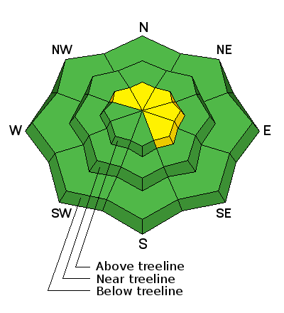
bottom line While the avalanche danger is generally LOW, a MODERATE avalanche danger exist on steep, upper elevation, leeward slopes, especially those facing the north half of the compass. Any avalanche that fails on weak, sugary snow near the ground, has the potential to break deeper and wider than you might expect.
|
 |
special announcement The Utah Avalanche Center greatly values in longtime partnership with our world-class resorts and is blowing out the remaining donated lift tickets from Alta, Snowbird, Snowbasin, Sundance, and Nordic Valley with reduced prices. Every penny you spend and turn you make benefits the Utah Avalanche Center. Check out our Garage Sale! Chock full of sweet backcountry gear - you can find the goods on our Facebook page here. |
 |
current conditions Under mostly cloudy skies this morning the temperatures at 8,000' are in the upper 20's and at 10,000' it's in the low 20's. Make sure to have scratchers on the sleds and watch for over-heating as many of the lower elevation trail heads will be icy till you gain some elevation. We managed to squeeze a trace to a couple of inches of new snow in the past 24hr from this weak storm. Winds remain out of the west-south-west and have picked up, blowing 15-25mph gusting into the 40's across the high terrain. Many of the southerly facing slopes will be crusted today without much of a chance to heat up - mid and upper elevation, north facing terrain still offers soft settled powder. Uinta weather station network info is found here. Trip reports and observations are found here.
|
 |
recent activity No new avalanche activity was reported from the backcountry yesterday. Recent avalanche observations are found here See or trigger an avalanche? Shooting cracks? Hear a collapse? It's simple. Go here to fill out an observation.
|
| type | aspect/elevation | characteristics |
|---|

|
|
LIKELIHOOD
 LIKELY
UNLIKELY
SIZE
 LARGE
SMALL
TREND
 INCREASING DANGER
SAME
DECREASING DANGER
|
|
description
Less predictable, is any slide that fails on weak, sugary snow near the ground, or what we call persistent slabs. Remember- persistent slabs have the potential to break deeper and wider than you might expect. Steep, rocky terrain facing the north half of the compass and particularly slopes that avalanched near the ground earlier this season should be considered suspect. It's like a nagging toothache, this problem just doesn't seem to go away. During our Field day last Friday, Craig and I came to a steep north-east facing slope around 10,000' in elevation and decided to back off due to the poor snowpack structure. We are still finding places that have the right set up for producing avalanches. Yes, they are hard to trigger - but, if you do trigger one - it's likely to be deep and to the ground. Sled triggered avalanche in Gold Hill Basin, that Ted discovered from a week ago. Breaking 150' wide and failing on weak snow near the ground, check out Ted's great write-up here and video below. GOPR0029 from ted scroggin on Vimeo. |
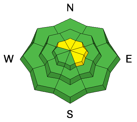
| type | aspect/elevation | characteristics |
|---|

|

|
LIKELIHOOD
 LIKELY
UNLIKELY
SIZE
 LARGE
SMALL
TREND
 INCREASING DANGER
SAME
DECREASING DANGER
|
|
description
The west-south-west winds picked up around 5:00pm yesterday as a cold front pushed into the area. I would expect the wind grabbed what little snow was available for transport and created fresh shallow wind slabs along upper elevation leeward slopes. Above tree line and on terrain steeper than 35 degrees, be on the lookout for fresh drifts of wind blown snow - fresh drifts sound hollow and look rounded and pillowy. Wind slab photo by the greatest guy on the eastern front (Ted Scroggin) showing the type of terrain and size of these new wind slabs. |
 |
weather We have a weak storm crossing the Uinta's this morning and if we are lucky we could see a couple inches of new snow. Winds remain out of the west-south-west blowing 20-25mph gusting into the 40's at 10,000 feet. Mountain temperatures should top out in the upper 20's to low 30's today before cooling off this evening. Plan on mostly cloudy skies with the occasional snow shower. By late afternoon we could see some clearing as high pressure returns on Tuesday.
|
| general announcements Remember your information can save lives. If you see anything we should know about, please participate in the creation of our own community avalanche advisory by submitting snow and avalanche conditions. You can call me directly at 801-231-2170, email [email protected], or email by clicking HERE If Craig is unavailable you can reach his partner Trent at 801-455-7239, email [email protected] This is a great time of year to schedule a free avalanche awareness presentation for your group or club. You can contact me at 801-231-2170 or email [email protected]. To register for the first in our series of on-the-snow sled specific classes you can register here. The information in this advisory is from the US Forest Service which is solely responsible for its content. This advisory describes general avalanche conditions and local variations always occur. The information in this advisory expires 24 hours after the date and time posted, but will be updated by 7:00 AM on Tuesday, March 1st.
|


