| Please join us at the 23rd annual Black Diamond Fall Fundraiser Party Thursday Sept 15. Tickets are on sale now here, at the Black Diamond store & at REI. Special bonus raffle for online ticket purchasers! |
| Please join us at the 23rd annual Black Diamond Fall Fundraiser Party Thursday Sept 15. Tickets are on sale now here, at the Black Diamond store & at REI. Special bonus raffle for online ticket purchasers! |
| Advisory: Uintas Area Mountains | Issued by Craig Gordon for Friday - February 26, 2016 - 5:03am |
|---|

|
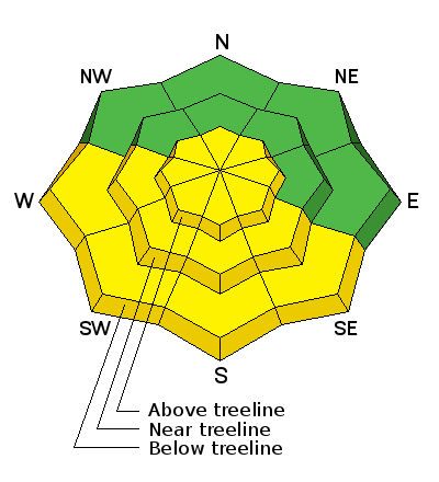
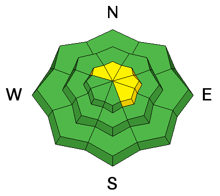
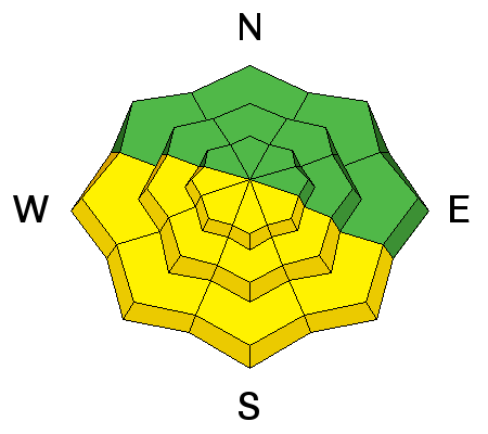
bottom line While the avalanche danger is generally LOW, pockets of MODERATE avalanche danger exist on steep, upper elevation, leeward slopes, especially those facing the north half of the compass. Yes... it's becoming more the exception than the rule, but any avalanche that fails on weak, sugary snow near the ground, has the potential to break deeper and wider than you might expect. The danger of wet sluffs and slides increases to MODERATE on steep sunny slopes and human triggered avalanches are possible with daytime heating.
|
 |
special announcement Check out our Garage Sale! Chock full of sweet backcountry gear - you can find the goods on our Facebook page here. |
 |
current conditions Skies are clear, winds light and variable, and temperatures in the upper teens and low 20's. Lower elevation sunny slopes are yeilding an early crop of supportable corn, but the higher you go in elevation, the less reliable the crust becomes. If you're looking for a sure bet, simply flip over to the north half of the compass and you'll still find soft, settled powder on a go-anywhere base.
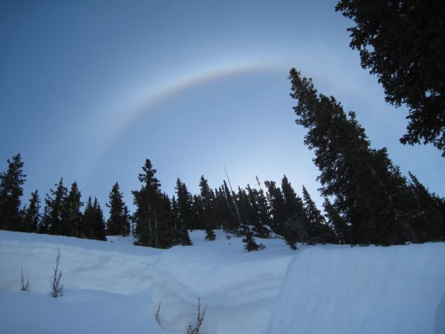
Ted caught this great sundog image late Wednesday while investigating a slide in the Gold Hill Basin. (Scroggin photo) Uinta weather station network info is found here. Trip reports and observations are found here.
|
 |
recent activity
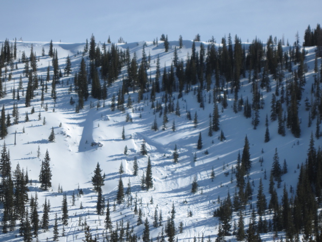
Ted was in Gold Hill Basin Wednesday and discovered this sled triggered slab from Saturday. Breaking 150' wide and failing on weak snow near the ground, check out Ted's great write-up and very informative video here. Recent avalanche observations are found here See or trigger an avalanche? Shooting cracks? Hear a collapse? It's simple. Go here to fill out an observation.
|
| type | aspect/elevation | characteristics |
|---|

|
|
LIKELIHOOD
 LIKELY
UNLIKELY
SIZE
 LARGE
SMALL
TREND
 INCREASING DANGER
SAME
DECREASING DANGER
|
|
description
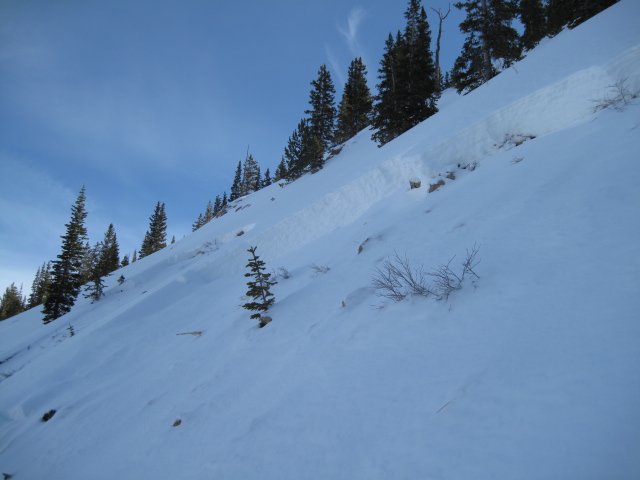
A few old wind drifts are found on steep leeward slopes in the wind zone, but these are generally manageable and predictably break at or below your feet. Less predictable, is any slide that fails on weak, sugary snow near the ground, or what we call persitent slabs. Remember- persistent slabs have the potential to break deeper and wider than you might expect. Steep, rocky terrain facing the north half of the compass and particularly slopes that avalanched near the ground earlier this season should be considered suspect.
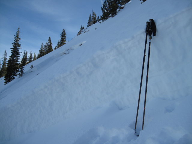
Breaking to weak snow in steep, rocky terrain... here's another pic Ted snapped from Gold Hill Wednesday. (Scroggin photo)
|
| type | aspect/elevation | characteristics |
|---|

|
|
LIKELIHOOD
 LIKELY
UNLIKELY
SIZE
 LARGE
SMALL
TREND
INCREASING DANGER
SAME
DECREASING DANGER
|
|
description
Sunny slopes will take on heat today and the danger of wet slides and sluffs increases as the day wares on. This type of avalanche dragon is easy to avoid... simply get off of and out from under steep sunny slopes during the heat of the day. |
 |
weather Another beautiful day is on tap. Look for mostly sunny skies and temperatures climbing into the low 40's with overnight lows in the upper 20's. Winds ramp up tonight ahead of the next cold front which is expected to reach the region tomorrow afternoon. Southerly winds crank in the 40's and 50's Saturday morning and clouds stream into the area, ushering in scattered snow showers. Not looking at a lot of snow out of this storm, but a more significant weather system is expected Monday. Stay tuned... we'll have more details on strength and timing tomorrow.
|
| general announcements Remember your information can save lives. If you see anything we should know about, please participate in the creation of our own community avalanche advisory by submitting snow and avalanche conditions. You can call me directly at 801-231-2170, email [email protected], or email by clicking HERE If Craig is unavailable you can reach his partner Trent at 801-455-7239, email [email protected] This is a great time of year to schedule a free avalanche awareness presentation for your group or club. You can contact me at 801-231-2170 or email [email protected]. To register for the first in our series of on-the-snow sled specific classes you can register here. The information in this advisory is from the US Forest Service which is solely responsible for its content. This advisory describes general avalanche conditions and local variations always occur. The information in this advisory expires 24 hours after the date and time posted, but will be updated by 7:00 AM on Saturday, February 27th.
|