| During the month of April, Mark Miller will donate $75 to the charity of your choice (5 to chose from, including the Utah Avalanche Center!) Mark Miller Subaru has raised over $300k in the previous 6 Do Good Feel Good events. More Info here |  |
| During the month of April, Mark Miller will donate $75 to the charity of your choice (5 to chose from, including the Utah Avalanche Center!) Mark Miller Subaru has raised over $300k in the previous 6 Do Good Feel Good events. More Info here | |
| Advisory: Uintas Area Mountains | Issued by Craig Gordon for Sunday - March 8, 2015 - 5:45am |
|---|

|
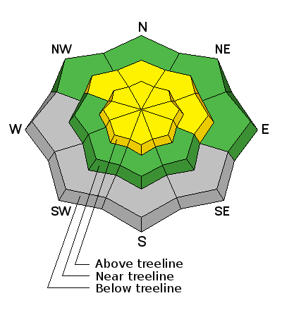
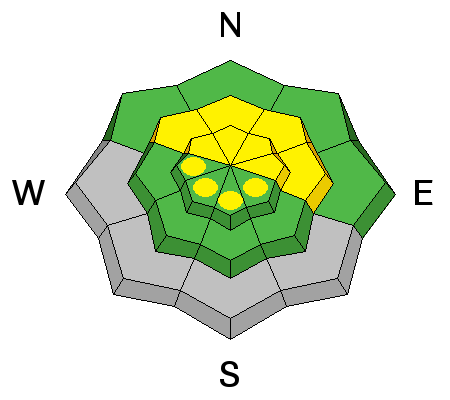
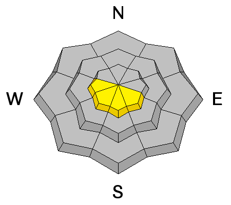
bottom line At and above treeline, on steep wind drifted slopes facing the north half of the compass you'll find pockets of MODERATE avalanche danger and human triggered slides are possible. Avalanches triggered in steep, rocky terrain have the potential to break deeper and wider than you might expect and could get quickly out of hand. On the other side of the compass, the danger of wet avalanches may rise to MODERATE on steep sunny slopes during the heat of the day. Most other terrain offers a LOW avalanche danger.
|
 |
current conditions Under clear skies and a big, bright, beautiful moon, temperatures only dipped into the low 20's overnight. Along the high peaks northerly winds are blowing 10-20 mph. Strong sunshine has taken its toll on low elevation roads and south facing terrain. However, gain a little elevation, swing around to the north half of the compass and you'll still find soft, settled, creamy snow on a go-anywhere base. Click here for real-time temperatures, snowfall, and winds.
Wow... HUGE air in the western Uinta's.
Elsewhere, people are getting into big terrain and not experiencing any avalanche issues where the snowpack is deep and strong.
|
 |
recent activity
This slide was triggered near the Duchesne Ridge. Here's the witness account- Witnessed a sled triggered slide today. Not sure what the rider was thinking. Did a high line in between two existing slides. I stopped to watch cause I couldn't believe they were actually doing it. Asked his buddy afterwards if they were trying to break the rest loose but he said they didn't expect that. Rider almost rode out the top of the slide as is started. Sled got tumbled and rider did a good job of swimming on his back to stay on top. Slide was very slow but fluid until it stopped. He was partially buried but ok.
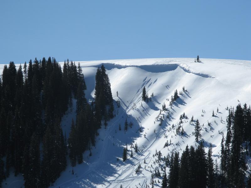
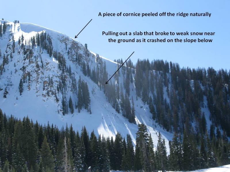
On the North Slope, I watched a natural cornice fall initiate a shallow slab on a steep, unsupported slope. The pocket broke to the ground, generating a good amount of debris... more the exception than the rule.
|
| type | aspect/elevation | characteristics |
|---|

|
|
LIKELIHOOD
 LIKELY
UNLIKELY
SIZE
 LARGE
SMALL
TREND
 INCREASING DANGER
SAME
DECREASING DANGER
|
|
description
Weak, sugary snow... it's the Uinta's Achilles heel and the culprit to a hand-full of recent human triggered slides this week. While not widespread, hard to trigger, and even harder to detect, today's avalanches still have the potential to break to weak snow near the ground. Our usual suspects come to mind... steep, rocky slopes with a thin, shallow snowpack. If you're getting into terrain with these characteristics remember- even a small slide breaking to the ground could quickly get out of hand, especially in steep committing terrain.
|
| type | aspect/elevation | characteristics |
|---|

|
|
LIKELIHOOD
LIKELY
UNLIKELY
SIZE
LARGE
SMALL
TREND
INCREASING DANGER
SAME
DECREASING DANGER
|
|
description
It's March and the sun is getting intense. As the day heats up and particularly if you're feeling like an ant under a magnifying glass, you'll want to get off of and out from under steep, sunny slopes. In addition, avoid terrain traps like gullies and road cuts where wet, cement-like debris can pile up very deeply.
Cornices aren't the ginormous monsters we're used to seeing this time of year, but they're definitely big enough to let you know who's boss. You'll want to avoid these unpredictable boxcars, especially during the heat of the day.
|
 |
weather A weak disturbance passing through the region brings cooler temperatures with highs reaching into the upper 30's. North and northwest winds remain in the 15-20 mph range along the high ridges. Sunny skies and warm temperatures return for the beginning of the week and it looks like a very weak system gives us a dusting of snow midweek. High pressure then builds into next weekend.
|
| general announcements Remember your information can save lives. If you see anything we should know about, please participate in the creation of our own community avalanche advisory by submitting snow and avalanche conditions. You can call me directly at 801-231-2170, email [email protected], or email by clicking HERE This is a great time of year to schedule a free avalanche awareness presentation for your group or club. You can contact me at 801-231-2170 or email [email protected] Donate to your favorite non-profit –The Utah Avalanche Center. The UAC depends on contributions from users like you to support our work. Benefit the Utah Avalanche Center when you buy or sell on ebay - set the Utah Avalanche Center as a favorite non-profit in your ebay account here and click on ebay gives when you buy or sell. You can choose to have your seller fees donated to the UAC, which doesn't cost you a penny. Utah Avalanche Center mobile app - Get your advisory on your iPhone along with great navigation and rescue tools. The information in this advisory is from the US Forest Service which is solely responsible for its content. This advisory describes general avalanche conditions and local variations always occur. I will update this advisory by 7:00 AM Wednesday Mar. 11, 2015. |


_0.jpg)