| During the month of April, Mark Miller will donate $75 to the charity of your choice (5 to chose from, including the Utah Avalanche Center!) Mark Miller Subaru has raised over $300k in the previous 6 Do Good Feel Good events. More Info here |  |
| During the month of April, Mark Miller will donate $75 to the charity of your choice (5 to chose from, including the Utah Avalanche Center!) Mark Miller Subaru has raised over $300k in the previous 6 Do Good Feel Good events. More Info here | |
| Advisory: Uintas Area Mountains | Issued by Craig Gordon for Thursday - December 25, 2014 - 6:06am |
|---|

|
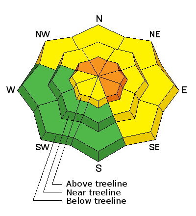
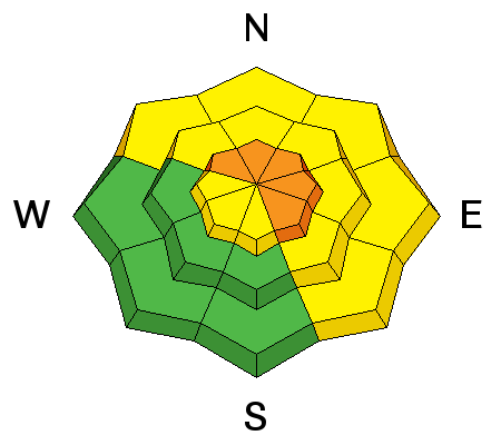
bottom line At upper elevations at and above treeline, the avalanche danger is CONSIDERABLE. Human triggered avalanches are probable on steep, wind drifted slopes facing the north half of the compass, especially terrain with an easterly component to its aspect. Any slide triggered today has the potential to break deep and wide, resulting in a dangerous and possibly unsurvivable avalanche. A MODERATE avalanche danger exists on recently wind loaded slopes at mid elevations and human triggered avalanches are possible A LOW avalanche danger exists on low and mid elevation slopes facing the south half of the compass.
|
 |
special announcement Bruce, Otis Redding, and I wanna wish you a Merry Christmas... turn it up!
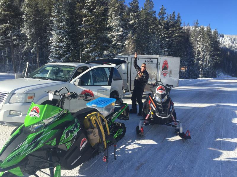
Emerging from the UAC stokemobile.... Craig and Trent gear up for a little cold smoke, two stroke, pow stoke! Huge thanks to all of our great partners including Sam T Evans and Look Trailers for generously donating a loaner two place sled trailer for the 2014-15 season.... y'all rock! We just released an exciting, new avy safety video designed specifically for snowmobilers - Knowledge is Powder. https://vimeo.com/113677686 NEW THIS YEAR: You can now receive advisories by email for each region in the state. Go here for details.
|
 |
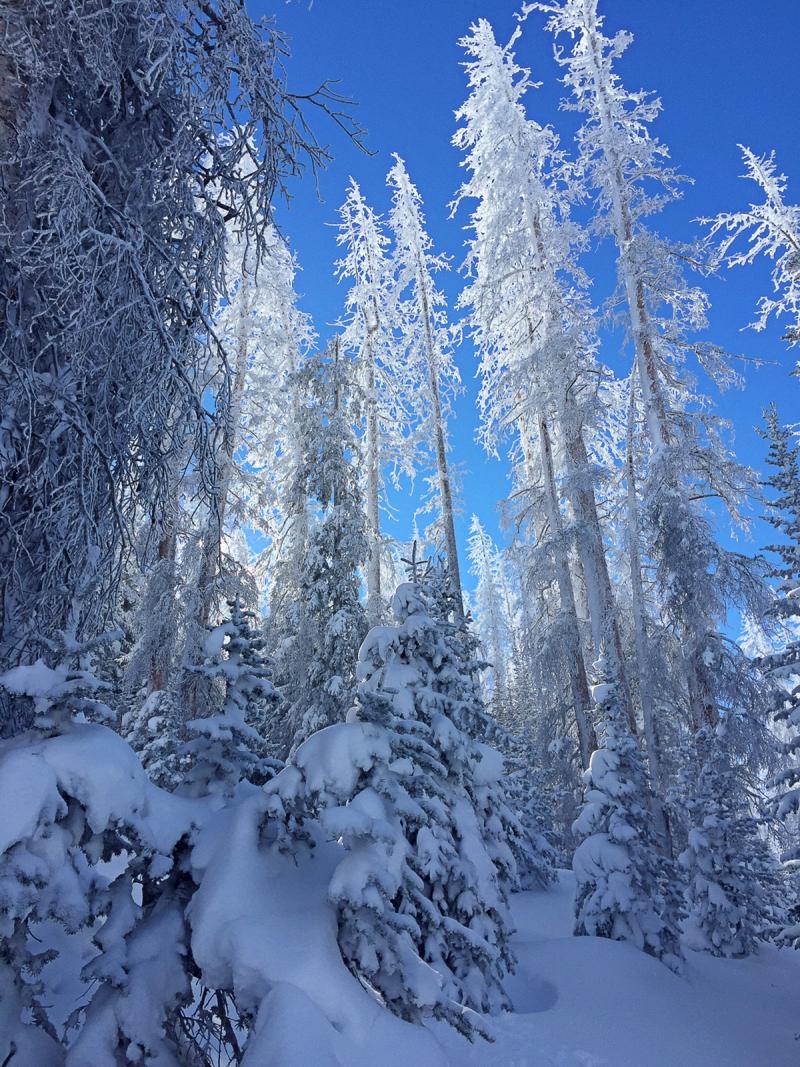
current conditions South and southwest winds ramped up late yesterday afternoon, blowing in the 30's and 40's, with gusts near 70 mph along the high peaks. They mellowed somewhat around 4:00 this morning and are currently blowing 25-35 mph. The storm moved in over the region around midnight and the range has picked up 6" of medium density snow. Temperatures are in the mid teens. The coverage has gone from zero to hero and excellent riding and turning conditions are found, especially on mid elevation, wind sheltered slopes.
The coverage has gone from zero to hero and excellent riding and turning conditions are found, especially on mid elevation, wind sheltered slopes. Click here for winds, temps, and snowfall.
|
 |
recent activity
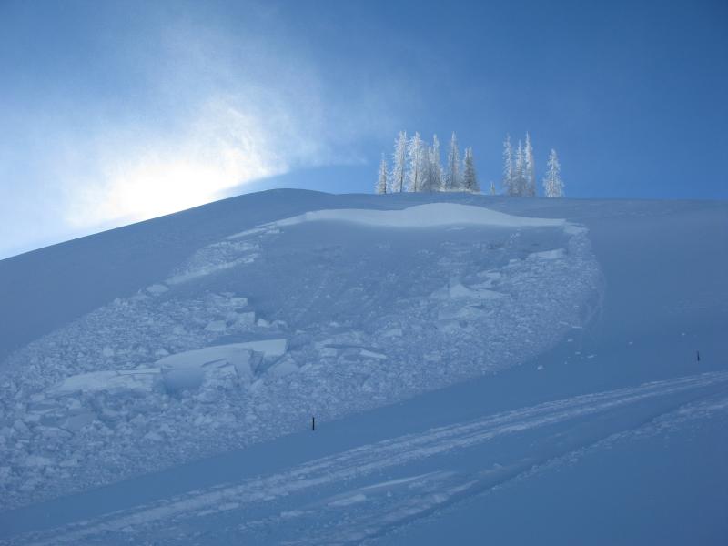
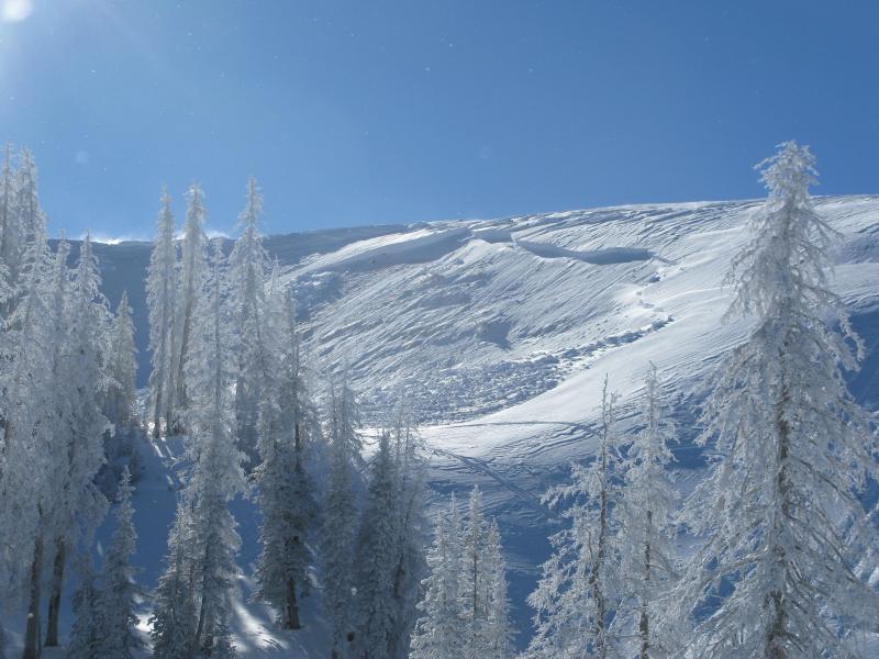
A couple sled triggered slides near Tower Mountain on Tuesday occurring on heavily wind loaded east and northeast facing terrain. Fortunately, the debris fanned out and no one was caught, buried, or injured, but the writing is on the wall and avalanche conditions remain sketchy in the western Uinta's. Recent trip reports, backcountry observations, and avalanche observations are found here.
|
| type | aspect/elevation | characteristics |
|---|

|
|
LIKELIHOOD
 LIKELY
UNLIKELY
SIZE
 LARGE
SMALL
TREND
 INCREASING DANGER
SAME
DECREASING DANGER
|
|
description
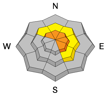
Strong ridgetop winds overnight started moving quite a bit of snow around and fresh wind drifts are gonna be the most obvious avalanche dragon out there today. Fat and rounded in their appearance, these mini whales formed on upper elevation, leeward slopes facing the north half of the compass. While mostly manageable in size and depth, today's wind slabs will be sensitive to the additional weight of a rider. With more snow and wind forecast throughout the day, this mornings predictable avalanche conditions may become a little more rowdy, breaking deeper and wider as the day progresses. Remember- whoomphing sounds or shooting cracks in front of your skis, board, or sled are huge clues to unstable snow. And don't forget the biggest clue... recent avalanches! Especially if they're occurring on the same kind of slope you wanna ride on.
|
| type | aspect/elevation | characteristics |
|---|

|
|
LIKELIHOOD
LIKELY
UNLIKELY
SIZE
LARGE
SMALL
TREND
 INCREASING DANGER
SAME
DECREASING DANGER
|
|
description
More deceptive, not so easy to detect, and even less manageable are avalanches that break to weak layers of snow near the ground. It's what we call persistent slabs. Here's a great video illustrating why they're so dangerous. Any avalanche triggered today has the potential to break into weak layers near the ground, producing a large and dangerous slide. Avoid steep wind drifted terrain and you avoid the problem
Unpredictable, dangerous, and triggered on relatively low angle terrain, this recent slide on the Roundy Basin Ridge broke to weak snow near the ground. |
 |
weather Snow, heavy at times continues through the day. An additional 4"-8" is a good bet. High temperatures don't vary much from where we're at this morning and overnight lows dip into the single digits. Winds near the ridgetops decrease into the teens and low 20's, switch to the north, and then northeast this evening and overnight. A few lingering showers continue into Friday before tapering off in the evening. Another cold storm is on track for late Saturday night through Monday night. |
| general announcements Remember your information can save lives. If you see anything we should know about, please participate in the creation of our own community avalanche advisory by submitting snow and avalanche conditions. You can call me directly at 801-231-2170, email [email protected], or email by clicking HERE This is a great time of year to schedule a free avalanche awareness presentation for your group or club. You can contact me at 801-231-2170 or email [email protected] Donate to your favorite non-profit –The Utah Avalanche Center. The UAC depends on contributions from users like you to support our work. Benefit the Utah Avalanche Center when you buy or sell on ebay - set the Utah Avalanche Center as a favorite non-profit in your ebay account here and click on ebay gives when you buy or sell. You can choose to have your seller fees donated to the UAC, which doesn't cost you a penny. Utah Avalanche Center mobile app - Get your advisory on your iPhone along with great navigation and rescue tools. The information in this advisory is from the US Forest Service which is solely responsible for its content. This advisory describes general avalanche conditions and local variations always occur. I will update this advisory by 7:00 AM Friday Dec. 26, 2014. |


_0.jpg)