
| During the month of April, Mark Miller will donate $75 to the charity of your choice (5 to chose from, including the Utah Avalanche Center!) Mark Miller Subaru has raised over $300k in the previous 6 Do Good Feel Good events. More Info here |  |
| During the month of April, Mark Miller will donate $75 to the charity of your choice (5 to chose from, including the Utah Avalanche Center!) Mark Miller Subaru has raised over $300k in the previous 6 Do Good Feel Good events. More Info here | |
| Advisory: Uintas Area Mountains | Issued by Craig Gordon for Tuesday - November 25, 2014 - 6:25am |
|---|


|
bottom line A CONSIDERABLE avalanche danger exists on wind drifted slopes at mid and upper elevations. Human triggered avalanches are probable on leeward slopes facing the north half of the compass. Remember- triggering even a small slide will expose stumps and rocks, instantly ruing your day and quite possibly your season. Looking for LOW avalanche danger? Head to slopes that had no pre-existing snow prior to the big weekend storm.
|
 |
special announcement NEW THIS YEAR: You can now receive advisories by email for each region in the state. Go here for details. |
 |
current conditions Clouds, winds, and temperatures are all on the rise as a weak storm slides through the region early today. Currently, west and northwest winds are blowing 30-50 mph along the high ridges. Temperatures have risen 10 degrees overnight and are in the mid to upper teens. Travel has vastly improved with the big weekend storm, though the range is still pretty thin, and riding and turning options remain limited.
|
 |
recent activity Like riding in a milk jug... visibility was limited yesterday, but lots of collapses and booming whoomphing sounds were reported from across the range.
|
| type | aspect/elevation | characteristics |
|---|

|
|
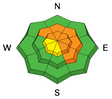
LIKELIHOOD
 LIKELY
UNLIKELY
SIZE
 LARGE
SMALL
TREND
 INCREASING DANGER
SAME
DECREASING DANGER
|
|
description
Rising temperatures, strong winds, and more snow on the way equates to sketchy avalanche conditions, especially on mid and upper elevation shady slopes, facing the north half of the compass. And here's why. First... underneath the big weekend storm is early season snow that grew weak and sugary and recent winds drifted snow everywhere. Second... your choices for riding or turning are limited to mid and high elevation snow facing the north half of the compass, and that's exactly the type of terrain where you could trigger an avalanche today. And finally... the snow will feel solid and supportable, but it's strong snow resting on weak snow and that's a dangerous combination. So we've gotta think not only about the snow we're riding in, but also the snow we're riding on. |
 |
weather A warm front slides through the region today, bringing strong ridgetop winds, temperatures climbing into the mid 20's, and around 6" of dense snow. High pressure builds late tonight and we should see clearing skies and warm temperatures for the last half of the week. Clouds drift over the range this weekend and a promising system could develop for early next week. Stay tuned. |
| general announcements Remember your information can save lives. If you see anything we should know about, please participate in the creation of our own community avalanche advisory by submitting snow and avalanche conditions. You can call me directly at 801-231-2170, email [email protected], or email by clicking HERE This is a great time of year to schedule a free avalanche awareness presentation for your group or club. You can contact me at 801-231-2170 or email [email protected] Donate to your favorite non-profit –The Utah Avalanche Center. The UAC depends on contributions from users like you to support our work. Benefit the Utah Avalanche Center when you buy or sell on ebay - set the Utah Avalanche Center as a favorite non-profit in your ebay account here and click on ebay gives when you buy or sell. You can choose to have your seller fees donated to the UAC, which doesn't cost you a penny. Utah Avalanche Center mobile app - Get your advisory on your iPhone along with great navigation and rescue tools. The information in this advisory is from the US Forest Service which is solely responsible for its content. This advisory describes general avalanche conditions and local variations always occur. I will update this advisory by 7:00 AM Wednesday Nov. 26, 2014. |


_0.jpg)