| During the month of April, Mark Miller will donate $75 to the charity of your choice (5 to chose from, including the Utah Avalanche Center!) Mark Miller Subaru has raised over $300k in the previous 6 Do Good Feel Good events. More Info here |  |
| During the month of April, Mark Miller will donate $75 to the charity of your choice (5 to chose from, including the Utah Avalanche Center!) Mark Miller Subaru has raised over $300k in the previous 6 Do Good Feel Good events. More Info here | |
| Advisory: Uintas Area Mountains | Issued by Craig Gordon for Wednesday - March 19, 2014 - 5:51am |
|---|


|
bottom line In the wind zone, a MODERATE avalanche danger exists on leeward slopes and human triggered avalanches are possible in steep, wind drifted terrain. While not widespread, once initiated, today's avalanches can break deep and wide, creating a very dangerous slide. Mid and low elevation wind sheltered terrain offers a generally LOW avalanche danger.
.
|
 |
special announcement Can you change Utah in a day? Utah's non-profit community is a big part of what makes living in Utah great. Join your community in a state-wide day of non-profit appreciation and support with Love Utah Give Utah on Thursday, March 20. Your donation to the Utah Avalanche Center between now and March 20 through this link, large or small, helps pay for avalanche advisories and education and makes the Utah Avalanche Center eligible for challenge grants and special awards provided by local businesses. In Salt Lake City? Stop by Squatters downtown on Thursday 3/20 between 4 and 6 for some free snacks, an opportunity to chat with some of the UAC folks, and make an online donation. |
 |
current conditions Skies cleared late yesterday and under a big, bright, beautiful moon.... man it's cold out there this morning! Temperatures are near zero along the ridges and in the single digits at most other mountain locations. Northerly winds are blowing 10-15 mph with a few high peaks reporting gusts in the low 30's. Monday nights' storm was legit, delivering a solid 8"-10" of cold, light powder across the range. You'll wanna get after it early before the sun has its way. Click here for current winds, temperatures, and snowfall throughout the range. Click here for trip reports.
|
 |
recent activity No recent avalanche activity to report. Archived avalanche activity is found here.
|
| type | aspect/elevation | characteristics |
|---|

|

|
LIKELIHOOD
 LIKELY
UNLIKELY
SIZE
 LARGE
SMALL
TREND
 INCREASING DANGER
SAME
DECREASING DANGER
|
|
description
Winds were all over the place, gusting into the 70's and 80's as the Monday storm rolled through the region. Fortunately, snow began falling as winds decreased and I think most of the storm slabs are predictable and pretty straightforward, breaking at or below your skis, board, or sled. However, before charging into big terrain today, start off with some mini-golf. Tweak small test slopes and see how they're reacting before committing to a steep, technical slope. While not widespread, a triggered wind drift could get quickly out of hand if it breaks into sugary, old snow, buried deep in the snowpack.
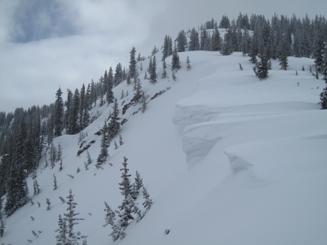
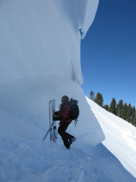
The intrepid Ted Scroggin was in Gold Hill Basin yesterday and noted large cornices had grown as a result of recent winds. More of his trip report can be found here.
.
|
| type | aspect/elevation | characteristics |
|---|

|
|
LIKELIHOOD
LIKELY
UNLIKELY
SIZE
 LARGE
SMALL
TREND
 INCREASING DANGER
SAME
DECREASING DANGER
|
|
description
It's been a week since our last report of a slide breaking into old snow near the ground and that's a good sign. However, it doesn't mean the snowpack has mysteriously healed itself and we're good to go. In fact, it's these type of avalanche conditions that have me on edge because we can ride plenty of slopes and not trigger a deep, scary slide, and this often gives us a false sense of stable snow. While there's plenty of slopes offering green light conditions, steep, rocky terrain, facing the north half of the compass remains suspect. Unless you have a detailed history of the slope you plan to ride and know it's avalanched to the ground at some point this season, given the consequences, it's best to avoid terrain with these characteristics.
Steep, rocky terrain still offers sketchy avalanche conditions. |
 |
weather High pressure is building and it'll be a spectacular day on the eastern front. Temperatures climb into the low 30's with overnight lows in the teens. West and southwest winds increase late in the day blowing to 20 mph by about dinnertime. A dry cold front crosses northern Utah Thursday evening and a weak storm slides through the area on Saturday. Maybe a more promising storm about a week from now.
|
| general announcements Remember your information can save lives. If you see anything we should know about, please participate in the creation of our own community avalanche advisory by submitting snow and avalanche conditions. You can call me directly at 801-231-2170, email [email protected], or email by clicking HERE This is a great time of year to schedule a free avalanche awareness presentation for your group or club. You can contact me at 801-231-2170 or email [email protected] Donate to your favorite non-profit –The Utah Avalanche Center. The UAC depends on contributions from users like you to support our work. Benefit the Utah Avalanche Center when you buy or sell on ebay - set the Utah Avalanche Center as a favorite non-profit in your ebay account here and click on ebay gives when you buy or sell. You can choose to have your seller fees donated to the UAC, which doesn't cost you a penny. Utah Avalanche Center mobile app - Get your advisory on your iPhone along with great navigation and rescue tools. The information in this advisory is from the US Forest Service which is solely responsible for its content. This advisory describes general avalanche conditions and local variations always occur. I will update this advisory by 7:00 AM on Saturday Mar. 22, 2014 or sooner if conditions warrant. |


_0.jpg)