
| During the month of April, Mark Miller will donate $75 to the charity of your choice (5 to chose from, including the Utah Avalanche Center!) Mark Miller Subaru has raised over $300k in the previous 6 Do Good Feel Good events. More Info here |  |
| During the month of April, Mark Miller will donate $75 to the charity of your choice (5 to chose from, including the Utah Avalanche Center!) Mark Miller Subaru has raised over $300k in the previous 6 Do Good Feel Good events. More Info here | |
| Advisory: Uintas Area Mountains | Issued by Craig Gordon for Thursday - February 6, 2014 - 5:45am |
|---|

|
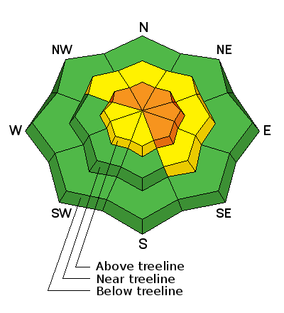
bottom line The avalanche danger will be rising the next couple of days. Above treeline in the wind zone, you'll find a CONSIDERABLE danger today and human triggered avalanches are likely on steep, wind drifted slopes. The danger is most pronounced on slopes with an easterly component to their aspect. A scary MODERATE avalanche danger is found on steep, rocky, upper elevation slopes, particularly those facing the north half of the compass. Once triggered, avalanches have the possibility to break deep and wide, creating a dangerous avalanche. Wind sheltered mid and low elevation terrain offers a LOW avalanche danger.
|
 |
avalanche watch THIS AVALANCHE WATCH IS FOR ALL THE MOUNTAINS OF NORTHERN UTAH, WESTERN UINTAS AND THE WASATCH PLATEAU. A WINTER STORM WITH AN EXTENDED PERIOD OF SNOWFALL, INTENSIFYING WEST WIND, AND GRADUALLY WARMING TEMPERATURES WILL OVERLOAD EXISTING WEAK LAYERS OF SNOW. THIS WILL CREATE DANGEROUS AVALANCHE CONDITIONS IN THE BACKCOUNTRY. DRIFTING SNOW WILL CAUSE THE AVALANCHE DANGER TO RISE THROUGHOUT TODAY AND OVERNIGHT. DANGEROUS AVALANCHE CONDITIONS WILL LIKELY DEVELOP BY FRIDAY AND LAST THROUGH THE WEEKEND. THIS WATCH DOES NOT INCLUDE SKI AREAS OR HIGHWAYS WHERE AVALANCHE CONTROL IS NORMALLY DONE. |
 |
current conditions Skies are partly to mostly cloudy and temperatures in the mid teens with single digits along the ridges. Westerly winds ramped up late last night and are currently blowing 30-40 mph along the high peaks. Riding and turning conditions are quite good, especially in wind sheltered terrain. Click here for current winds, temperatures, and snowfall throughout the range. Click here for trip reports and avalanche observations.
|
 |
recent activity No news of the weird. Recent avalanche activity is found here.
|
| type | aspect/elevation | characteristics |
|---|

|
|
LIKELIHOOD
 LIKELY
UNLIKELY
SIZE
 LARGE
SMALL
TREND
 INCREASING DANGER
SAME
DECREASING DANGER
|
|
description
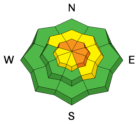
Winds ramped up overnight and the benign avalanche conditions we've all been enjoying are beginning to change. As a prolonged period of storminess develops, wind drifts will break deeper and wider than you might expect. Raging ridgetop winds will become a major player for the range and there's no shortage of light density snow to blow around. As the snow stacks up and winds continue to blow, look for and avoid any fat, rounded, pillow of snow. Remember- cracking and collapsing of the snowpack are huge signs to unstable snow.
.
|
| type | aspect/elevation | characteristics |
|---|

|
|
LIKELIHOOD
 LIKELY
UNLIKELY
SIZE
 LARGE
SMALL
TREND
INCREASING DANGER
SAME
DECREASING DANGER
|
|
description
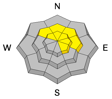
It's been several weeks since we've seen or heard about any avalanches breaking into deeply buried weak layers near the ground. That's good news and I think we're probably on our way to turning the corner towards a stronger pack where the snow is deep and strong. However, steep, upper elevation, rocky slopes, especially those facing the north half of the compass remain suspect and need to be approached with caution. Gather as much information as possible by tweaking small test slopes with similar characteristics before center-punching big terrain. Above all- think about the consequences of triggering a slide that breaks to the ground.
|
 |
weather Looks like there's more confidence for a stormy period coming together. Increasing clouds and wind today with a few inches of snow expected late in the day. West and southwest winds blow in the 30's and 40's along the ridges and temperatures climb into the upper teens. Snowfall rates increase Friday morning and then the main event begins Saturday. Should be a good storm for the range with a couple feet stacking up when it all winds down on Monday.
|
| general announcements Remember your information can save lives. If you see anything we should know about, please participate in the creation of our own community avalanche advisory by submitting snow and avalanche conditions. You can call me directly at 801-231-2170, email [email protected], or email by clicking HERE This is a great time of year to schedule a free avalanche awareness presentation for your group or club. You can contact me at 801-231-2170 or email [email protected] Donate to your favorite non-profit –The Utah Avalanche Center. The UAC depends on contributions from users like you to support our work. Benefit the Utah Avalanche Center when you buy or sell on ebay - set the Utah Avalanche Center as a favorite non-profit in your ebay account here and click on ebay gives when you buy or sell. You can choose to have your seller fees donated to the UAC, which doesn't cost you a penny. Utah Avalanche Center mobile app - Get your advisory on your iPhone along with great navigation and rescue tools. The information in this advisory is from the US Forest Service which is solely responsible for its content. This advisory describes general avalanche conditions and local variations always occur. I will update this advisory by 7:00 AM on Friday Feb. 7, 2014 |


_0.jpg)
