| During the month of April, Mark Miller will donate $75 to the charity of your choice (5 to chose from, including the Utah Avalanche Center!) Mark Miller Subaru has raised over $300k in the previous 6 Do Good Feel Good events. More Info here |  |
| During the month of April, Mark Miller will donate $75 to the charity of your choice (5 to chose from, including the Utah Avalanche Center!) Mark Miller Subaru has raised over $300k in the previous 6 Do Good Feel Good events. More Info here | |
| Advisory: Uintas Area Mountains | Issued by Craig Gordon for Saturday - January 18, 2014 - 4:44am |
|---|

|
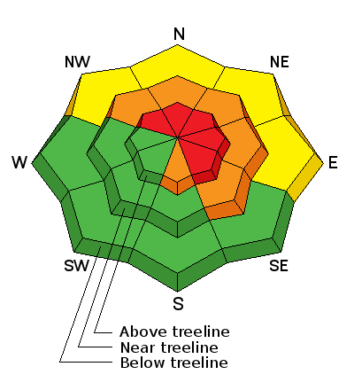
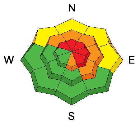
bottom line Avalanches are harder to initiate, but if you do trigger a slide the end result will be devastating! Terrain to avoid- steep, upper elevation slopes facing the north half of the compass, especially those in the wind zone with an easterly component to their aspect, where a HIGH avalanche danger exists. Human triggered avalanches are very likely. A CONSIDERABLE avalanche danger is found on any steep wind drifted slope at mid elevations. Human triggered avalanches are likely. Go to terrain- If you're looking for LOW avalanche danger, head to wind sheltered terrain, especially those facing the south half of the compass where there are no steep slopes above or adjacent to where you're riding.
|
 |
special announcement
This is the type of slide you'll be staring down if you trigger an avalanche today. Very dangerous avalanche conditions exist, particularly on steep, upper elevation slopes facing north, northeast and east. Deep, dangerous, and possibly unsurvivable human triggered avalanches are likely today in terrain with these characteristics. Trent put together a brilliant viddy describing the snowpack setup. Click here to view. |
 |
current conditions Skies are clear and temperatures are in the upper teens and low 20's. Northwest winds have mellowed somewhat overnight, but continue blowing 20-30 mph along the high peaks. Wind exposed terrain has taken a hard hit, but we continue to find soft settled powder, especially in mid and low elevation sheltered terrain. Meadows with no steep slopes above you are the ticket today.
Click here for current winds, temperatures, and snowfall throughout the range. Click here for trip reports and avalanche observations.
|
 |
recent activity
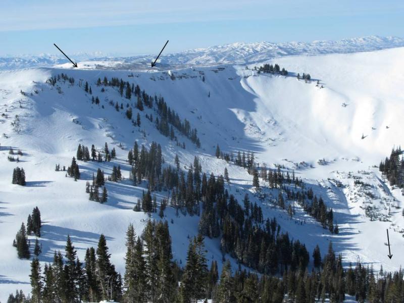
The all intrepid Ted Scroggin found yet another avalanche that broke to the ground during last weeks big avalanche cycle. This slide occurred on Double Hill.
Even more recent avalanche activity is found here.
|
| type | aspect/elevation | characteristics |
|---|

|
|
LIKELIHOOD
 LIKELY
UNLIKELY
SIZE
 LARGE
SMALL
TREND
 INCREASING DANGER
SAME
DECREASING DANGER
|
|
description
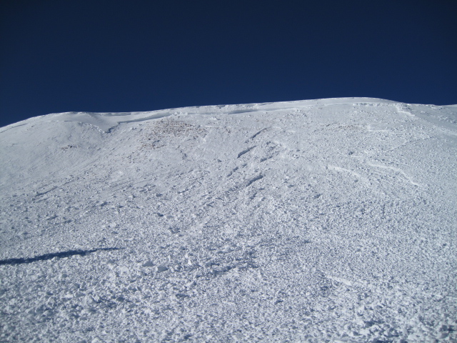
This has been an eye-opening and in many cases an eye-popping avalanche cycle for the western Uinta's. Seeing the large natural slide in Chalk Creek just two days ago on Thursday, over-running low angle benches and safe zones, is a slap in the face to snow stability. Yeah.... it's still pretty spooky out there. Many steep slopes that didn't avalanche are waiting for us to come along and pull the rug out from underneath. Problem with our current snowpack setup is the snow will allow us to get well out onto the slope before it fails on sugary old snow near the ground. Once initiated, today's slides will break deep and wide, creating an unsurvivable avalanche. Complicating matters is the fact that you may still be able to trigger avalanches low on the slope. Remember- most avalanche accidents occur the first few sunny days right after a big storm. It doesn't mean you can't ride. It does mean you need to stay off of and out from under steep wind drifted slopes, especially slopes facing the north half of the compass with an easterly component to their aspect.
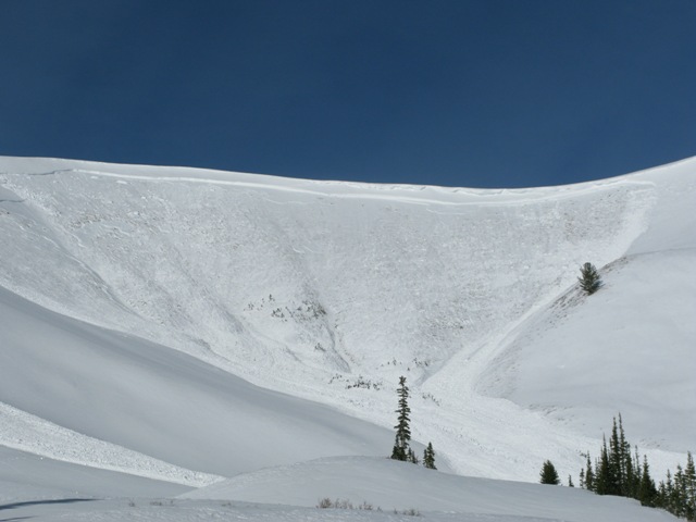
A bump in the winds Wednesday night triggered this long running avalanche on a steep northerly facing slope in upper Chalk Creek. The upper arrows indicate the width, while the lower arrow shows just how far this slide ran.
|
| type | aspect/elevation | characteristics |
|---|

|
|
LIKELIHOOD
LIKELY
UNLIKELY
SIZE
LARGE
SMALL
TREND
INCREASING DANGER
SAME
DECREASING DANGER
|
|
description
Cornices are huge, especially on the leeward side of upper elevation ridges. These monsters may be harder to peel off, but there's a distinct they'll break back further than you might expect, resulting in a nasty, unexpected ride down the elevator shaft, and possibly triggering a large avalanche as you both hit the slope below..
|
 |
weather Strong high pressure maintains a dry and mild airmass throughout the weekend and much of the following week. Sunny skies with temperatures climbing into the mid to upper 30's are on tap with diminishing ridgetop winds. No storms in sight.
|
| general announcements Remember your information can save lives. If you see anything we should know about, please participate in the creation of our own community avalanche advisory by submitting snow and avalanche conditions. You can call me directly at 801-231-2170, email [email protected], or email by clicking HERE This is a great time of year to schedule a free avalanche awareness presentation for your group or club. You can contact me at 801-231-2170 or email [email protected] Donate to your favorite non-profit –The Utah Avalanche Center. The UAC depends on contributions from users like you to support our work. Benefit the Utah Avalanche Center when you buy or sell on ebay - set the Utah Avalanche Center as a favorite non-profit in your ebay account here and click on ebay gives when you buy or sell. You can choose to have your seller fees donated to the UAC, which doesn't cost you a penny. Utah Avalanche Center mobile app - Get your advisory on your iPhone along with great navigation and rescue tools. The information in this advisory is from the US Forest Service which is solely responsible for its content. This advisory describes general avalanche conditions and local variations always occur. I will update this advisory by 7:00 AM on Sunday Jan. 19, 2014 |


_0.jpg)