| During the month of April, Mark Miller will donate $75 to the charity of your choice (5 to chose from, including the Utah Avalanche Center!) Mark Miller Subaru has raised over $300k in the previous 6 Do Good Feel Good events. More Info here |  |
| During the month of April, Mark Miller will donate $75 to the charity of your choice (5 to chose from, including the Utah Avalanche Center!) Mark Miller Subaru has raised over $300k in the previous 6 Do Good Feel Good events. More Info here | |
| Advisory: Uintas Area Mountains | Issued by Craig Gordon for Tuesday - January 14, 2014 - 5:43am |
|---|

|
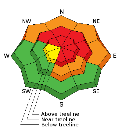
bottom line Nothing has changed here, this is the real deal. Think about the consequences of triggering a tree snapping, we're not coming home at the end of the day kinda slide. Terrain to avoid- steep, upper elevation slopes facing the north half of the compass, especially those in the wind zone with an easterly component to their aspect, where a HIGH avalanche danger exists. Both human triggered and natural avalanches are very likely. A CONSIDERABLE avalanche danger is found on any wind drifted slope at mid or low elevations. Natural and human triggered avalanches are likely. Go to terrain- If you're looking for LOW avalanche danger, head to wind sheltered terrain, especially those facing the south half of the compass where there are no steep slopes above or adjacent to where you're riding.
|
 |
avalanche warning AN AVALANCHE WARNING CONTINUES FOR THE WESTERN UINTA MOUNTAINS. VERY DANGEROUS AVALANCHE CONDITIONS EXIST...AVOID BEING ON OR BENEATH STEEP MOUNTAIN SLOPES... AS AVALANCHES MAY BE TRIGGERED LOW ON THE SLOPE AS WELL. |
 |
current conditions Skies are clearing in the wake of the weekend storm system, temperatures are in the teens and low 20's, and west winds continue their relentless assault, blowing 30-50 mph along high ridges. Riding and turning conditions are a mixed bag and there's a lot of wind damage out there. Wind sheltered mid and low elevation meadows with no steep slopes above you are the ticket. Ted found some challenging travel conditions yesterday in Gold Hill. His trip report can be found here.
Click here for current winds, temperatures, and snowfall throughout the range. Click here for trip reports and avalanche observations.
|
 |
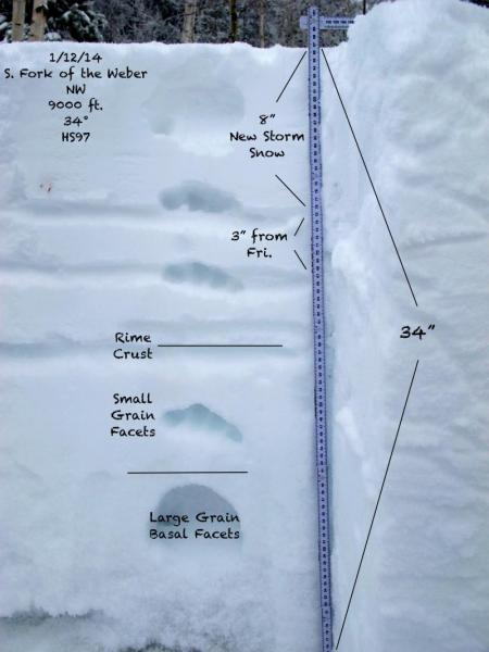
recent activity It was hard to see outside the ping pong ball yesterday, but a few glimpses of light revealed avalanches breaking to the ground in Upper Weber Canyon. Below are images from a slab in Smith-Moorehouse intentionally triggered on Sunday by a savvy skier while on belay. 2'-4' deep and 100' wide, the avalanche ran 800' vertical. More on this slide can be found here. Thanks to Elar for the great info!
|
| type | aspect/elevation | characteristics |
|---|

|
|
LIKELIHOOD
 LIKELY
UNLIKELY
SIZE
 LARGE
SMALL
TREND
 INCREASING DANGER
SAME
DECREASING DANGER
|
|
description
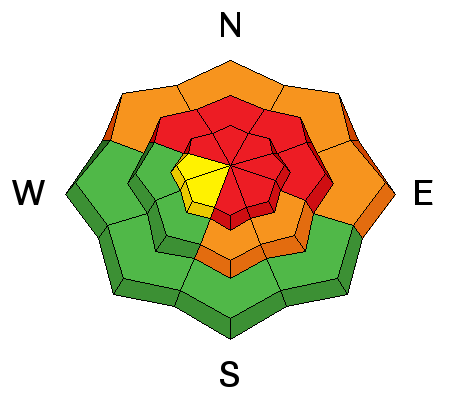
Most avalanches occur during a storm. Most avalanche accidents occur the first few sunny days right after a big storm. These are the type of conditions where most avalanche accidents happen in the western Uinta's. Right now we have a deceptively tricky snowpack because the snow will feel solid under our sled, skis, or board. However, we've got to get into the mind of the avalanche dragon and think of not only the snow we're riding in, but also the snow we're riding on... and quite frankly it's sketchy out there! The snow will allow us to get well out onto the slope before it fails on sugary old snow near the ground. Once initiated, today's slides will break deep and wide, creating an unsurvivable avalanche. Complicating matters is the fact that you can trigger avalanches low on the slope or from a distance. It doesn't mean you can't ride. It does mean you need to stay off of and out from under steep wind drifted slopes, especially slopes facing the north half of the compass.
As always, a great overview of the snowpack provided by JG. More of his outstanding observation and snowpack insight can be found here.
|
| type | aspect/elevation | characteristics |
|---|

|
|
LIKELIHOOD
LIKELY
UNLIKELY
SIZE
LARGE
SMALL
TREND
INCREASING DANGER
SAME
DECREASING DANGER
|
|
description
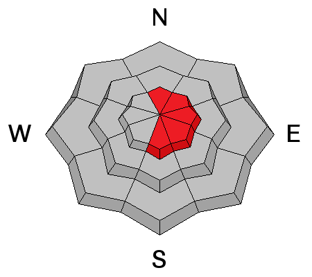
Cornices are huge, especially on the leeward side of upper elevation ridges. These monsters can easily break back further than you might expect, taking you for a nasty, unexpected ride down the elevator shaft, and possibly triggering a large avalanche as you both hit the slope below..
|
 |
weather Sunny skies and warming temperatures are on tap for today. West and northwest winds remain a nuisance along the high ridges, blowing in the 30's and 40's, eventually diminishing mid week. High temperatures climb into the upper 20's, dipping into the teens overnight. Dry and mild conditions are in store for us through the weekend.
|
| general announcements Remember your information can save lives. If you see anything we should know about, please participate in the creation of our own community avalanche advisory by submitting snow and avalanche conditions. You can call me directly at 801-231-2170, email [email protected], or email by clicking HERE This is a great time of year to schedule a free avalanche awareness presentation for your group or club. You can contact me at 801-231-2170 or email [email protected] Donate to your favorite non-profit –The Utah Avalanche Center. The UAC depends on contributions from users like you to support our work. Benefit the Utah Avalanche Center when you buy or sell on ebay - set the Utah Avalanche Center as a favorite non-profit in your ebay account here and click on ebay gives when you buy or sell. You can choose to have your seller fees donated to the UAC, which doesn't cost you a penny. Utah Avalanche Center mobile app - Get your advisory on your iPhone along with great navigation and rescue tools. The information in this advisory is from the US Forest Service which is solely responsible for its content. This advisory describes general avalanche conditions and local variations always occur. I will update this advisory by 7:00 AM on Wednesday Jan. 15, 2014 |


_0.jpg)

_0.jpg)
_0.jpg)