| During the month of April, Mark Miller will donate $75 to the charity of your choice (5 to chose from, including the Utah Avalanche Center!) Mark Miller Subaru has raised over $300k in the previous 6 Do Good Feel Good events. More Info here |  |
| During the month of April, Mark Miller will donate $75 to the charity of your choice (5 to chose from, including the Utah Avalanche Center!) Mark Miller Subaru has raised over $300k in the previous 6 Do Good Feel Good events. More Info here | |
| Advisory: Uintas Area Mountains | Issued by Craig Gordon for Saturday - January 4, 2014 - 6:11am |
|---|

|
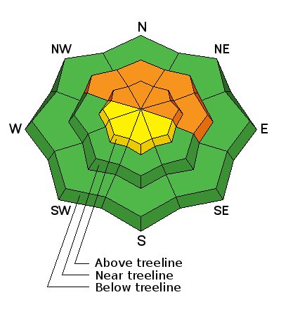
bottom line Terrain to avoid- steep, upper elevation slopes facing the north half of the compass, where a CONSIDERABLE avalanche danger is found and human triggered avalanches are likely. Once initiated, today's avalanches may break deeper and wider than you'd expect, creating an unmanageable and dangerous slide. A MODERATE avalanche danger exists in upper elevation terrain facing the south half of the compass and human triggered avalanches are possible on steep wind drifted slopes. If you're looking for LOW avalanche danger, head to wind sheltered terrain where there are no steep slopes above or adjacent to where you're riding.
|
 |
special announcement
Please join us at 7:00 on Monday Jan. 6th at Morgan Valley Polaris for a free avalanche awareness class for sledders... by sledders. Give the gift of STOKE! There are still a few slots open for our Avalanche and Riding Skills Workshop with Boondockers. Click here for more info. |
 |
current conditions A weak storm slid through the region early this morning, delivering 2"-3" of light density snow, markedly colder temperatures, and very strong ridgetop winds. Winds started cranking out of the southwest late yesterday, gusting to 60 mph, before switching to the northwest around midnight, and are currently blowing 30-40 mph along the ridges. Temperatures are in the low teens at most trailhead locations and single digits near the high peaks. While this little shot of snow will go a long way, riding and turning conditions are a mixed bag. Wind sheltered, mid elevation terrain is the ticket for soft, settled snow.. Click here for current winds, temperatures, and snowfall throughout the range. Click here for trip reports and avalanche observations.
|
 |
recent activity No significant new avalanche activity to report. |
| type | aspect/elevation | characteristics |
|---|

|
|
LIKELIHOOD
 LIKELY
UNLIKELY
SIZE
 LARGE
SMALL
TREND
 INCREASING DANGER
SAME
DECREASING DANGER
|
|
description
Fresh wind drifts along the leeward side of upper elevation ridges and around terrain features like chutes and gullies are going to be today's most obvious avalanche problem. However, don't get lulled into thinking this is the only avalanche dragon we're dealing with today. More concerning is the weak, sugary mess these solid feeling drifts formed on. We might forget about the weak layers, but our shallow snowpack has an amazing memory. Once triggered, a seemingly manageable wind slab can quickly get out of hand as it fails on weaker layers, buried deeper in the snowpack. Today's avalanches still have the possibility of breaking to weak snow near the ground. Steep, rocky, upper elevation slopes facing the north half of the compass remain suspect and should be treated as guilty until proven otherwise. Given the shallow snowpack conditions right now, an avalanche that breaks to the ground will take you for a season ending, body beating ride through rocks and stumps barely hidden under this thin veil of snow.
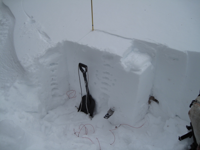
Our main man Ted Scroggin submitted this snowpit from yesterday. While not quite as reactive as even a few days ago, the snowpack continues to fail on weak snow near the ground, right at the level of Ted's snow saw. His trip report can be found here.
|
 |
weather Snow showers continue throughout the day and we might squeak another inch or two out of this system before high pressure builds and skies clear later today. In the meantime, northwest winds are gonna be a nuisance, gusting in the 30's and 40's along the high ridges. Temperatures barely climb out of the toe numbing teens before crashing to negative territory overnight. Sunny with a slow warming trend for Sunday and Monday with a series of weak systems on tap for mid week. There's much uncertainty with the current forecast, but the reality is... there are no big storms in sight.
|
| general announcements Remember your information can save lives. If you see anything we should know about, please participate in the creation of our own community avalanche advisory by submitting snow and avalanche conditions. You can call me directly at 801-231-2170, email [email protected], or email by clicking HERE This is a great time of year to schedule a free avalanche awareness presentation for your group or club. You can contact me at 801-231-2170 or email [email protected] Donate to your favorite non-profit –The Utah Avalanche Center. The UAC depends on contributions from users like you to support our work. Benefit the Utah Avalanche Center when you buy or sell on ebay - set the Utah Avalanche Center as a favorite non-profit in your ebay account here and click on ebay gives when you buy or sell. You can choose to have your seller fees donated to the UAC, which doesn't cost you a penny. Utah Avalanche Center mobile app - Get your advisory on your iPhone along with great navigation and rescue tools. The information in this advisory is from the US Forest Service which is solely responsible for its content. This advisory describes general avalanche conditions and local variations always occur. I will update this advisory by 7:00 AM on Sunday Jan. 5, 2014 |


_0.jpg)