| During the month of April, Mark Miller will donate $75 to the charity of your choice (5 to chose from, including the Utah Avalanche Center!) Mark Miller Subaru has raised over $300k in the previous 6 Do Good Feel Good events. More Info here |  |
| During the month of April, Mark Miller will donate $75 to the charity of your choice (5 to chose from, including the Utah Avalanche Center!) Mark Miller Subaru has raised over $300k in the previous 6 Do Good Feel Good events. More Info here | |
| Advisory: Uintas Area Mountains | Issued by Craig Gordon for Tuesday - December 24, 2013 - 6:10am |
|---|

|
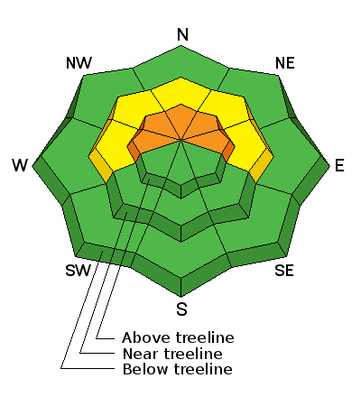
bottom line Terrain to avoid- steep, upper elevation slopes in the wind zone, particularly those facing the north half of the compass, where a CONSIDERABLE avalanche danger exists and human triggered avalanches are likely. Once initiated, today's avalanches will break deep and wide creating an unmanageable and dangerous slide. While not as widespread, a MODERATE avalanche danger is found in mid elevation shady terrain and human triggered avalanches are possible on steep wind drifted slopes. If you're looking for LOW avalanche danger, head to low elevation terrain or slopes facing the south half of the compass which had very little snow prior to last Thursday's big storm
|
 |
special avalanche bulletin THIS SPECIAL AVALANCHE ADVISORY IS FOR THE MOUNTAINS OF NORTHERN UTAH. A CONSIDERABLE AVALANCHE DANGER EXISTS FOR MOST MOUNTAIN AREAS OF NORTHERN UTAH. DANGEROUS HUMAN TRIGGERED AVALANCHES ARE LIKELY ON STEEP, UPPER ELEVATION, SHADY SLOPES AND BACKCOUNTRY TRAVEL IS NOT RECOMMENDED IN THESE AREAS. THIS ADVISORY DOES NOT INCLUDE SKI AREAS OR HIGHWAYS WHERE AVALANCHE CONTROL IS NORMALLY DONE. |
 |
special announcement The Utah Avalanche Center wishes you a safe and powder-filled holiday season. Please consider the UAC in your holiday giving plans - your donations pay for these advisories and we can't do this without your help. What is it worth to you every day to get an avalanche and mountain weather advisory? The cost of a beverage or the gas it takes to get up the canyon? You can donate here. Looking for a stocking stuffer? Give the gift of STOKE! There are still a few slots open for our Avalanche and Riding Skills Workshop with Boondockers. Click here for more info. |
 |
current conditions
What a mess and a blown forecast! Early Monday morning a saturated airmass settled in over the western Uinta's, laying down a coat of rime and essentially ruining any of the soft fluffy powder left over from the last storm. (If you wanna geek-out, check into Trent's explanation of how rime is formed). Temperatures have risen overnight and are currently in the low 30's at the trailheads and near 20 degrees along the ridges. Early this morning west and southwest winds bumped up and are currently blowing 35-55 mph near the high peaks. Boondocking in the trees could be the ticket for today where the crust seems a bit more user friendly. Click here for current winds, temperatures, and snowfall throughout the range. Click here for trip reports and avalanche observations.
|
 |
recent activity Visibility has been meager at best and there are no new reports of recent avalanche activity.
|
| type | aspect/elevation | characteristics |
|---|

|
|
LIKELIHOOD
 LIKELY
UNLIKELY
SIZE
 LARGE
SMALL
TREND
 INCREASING DANGER
SAME
DECREASING DANGER
|
|
description
I gotta be honest.... I'm not really sure how the rime event and subsequent crust will affect our snowpack stability. In the short term, surface crusts tend to help shrink wrap the snowpack, making it less sensitive to the additional weight of a rider. However, the structure of our snow- strong over weak- concerns me and I'm thinking not much has really changed. I know... it's sounds like I'm not quite ready for the long term relationship, right? So I'm going to keep things simple for the moment and yes, we can still be friends. I know that steep, shady, mid and upper elevation slopes harbor weak snow in the mid portion of the snowpack and there's a cohesive slab that rests on top of this mess. I know that all I need to do is find a weakness in the snowpack, collapse it, and now I've triggered an unmanageably large avalanche. So steep, mid and upper elevation slopes facing the north half of the compass are guilty until proven otherwise and should be avoided. Slopes facing the south half of the compass had very little old snow prior to last weeks big storm and in many cases storm snow fell on bare ground. This is go to terrain for today.
|
 |
weather A weak system brushes the north half of the state this morning, giving us an inch or two of snow. Temperatures slowly drop throughout the day and then skies clear this afternoon and temperatures crash to near zero overnight. In the mean time, westerly winds will be a nuisance as they gust into the 40's and 50's along the high peaks, but then diminish late in the day. Warm, dry high pressure builds on Christmas Day and lasts into early next week.
|
| general announcements Remember your information can save lives. If you see anything we should know about, please participate in the creation of our own community avalanche advisory by submitting snow and avalanche conditions. You can call me directly at 801-231-2170, email [email protected], or email by clicking HERE This is a great time of year to schedule a free avalanche awareness presentation for your group or club. You can contact me at 801-231-2170 or email [email protected] Donate to your favorite non-profit –The Utah Avalanche Center. The UAC depends on contributions from users like you to support our work. Benefit the Utah Avalanche Center when you buy or sell on ebay - set the Utah Avalanche Center as a favorite non-profit in your ebay account here and click on ebay gives when you buy or sell. You can choose to have your seller fees donated to the UAC, which doesn't cost you a penny. Utah Avalanche Center mobile app - Get your advisory on your iPhone along with great navigation and rescue tools. The information in this advisory is from the US Forest Service which is solely responsible for its content. This advisory describes general avalanche conditions and local variations always occur. I will update this advisory by 7:00 AM on Wednesday Dec. 25, 2013 |


_0.jpg)