| During the month of April, Mark Miller will donate $75 to the charity of your choice (5 to chose from, including the Utah Avalanche Center!) Mark Miller Subaru has raised over $300k in the previous 6 Do Good Feel Good events. More Info here |  |
| During the month of April, Mark Miller will donate $75 to the charity of your choice (5 to chose from, including the Utah Avalanche Center!) Mark Miller Subaru has raised over $300k in the previous 6 Do Good Feel Good events. More Info here | |
| Advisory: Uintas Area Mountains | Issued by Craig Gordon for Sunday - November 17, 2013 - 6:20am |
|---|

|
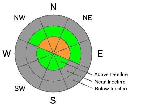
bottom line The avalanche danger is CONSIDERABLE today and human triggered avalanches are likely on steep, upper elevation, north facing slopes, especially those that had pre-existing snow prior to today's storm. Remember- even a small piece of snow can break to the ground, creating an unmanageable and possibly season ending situation. In terrain with no old snow prior to the weekend storm the avalanche danger is generally LOW.
|
 |
special announcement |
 |
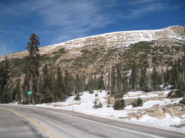
current conditions And then it was winter. Wow... what a storm! The Uinta's got slammed last night and storm totals are pretty impressive. It looks like the Mirror Lake area was the big winner with 18" stacking up and about a foot elsewhere throughout the range. West and southwest winds have been raging along the ridges for the past 24 hours. Blowing in the 30's and 40's on Saturday, winds ramped up around 4:00 yesterday afternoon into the 50's and 60's and they're still cranking early this morning. Temperatures are in the mid teens and low 20's. While we've virtually doubled our snowpack depths overnight, it's still pretty thin out there. Riding and turning options are limited to rock free meadows and roads. Click here for current winds, temperatures, and snowfall throughout the range.
Last weeks warm temperatures and strong sun nuked the south facing slopes.
|
 |
recent activity No recent avalanche activity to report.
|
| type | aspect/elevation | characteristics |
|---|

|
|
LIKELIHOOD
 LIKELY
UNLIKELY
SIZE
 LARGE
SMALL
TREND
 INCREASING DANGER
SAME
DECREASING DANGER
|
|
description
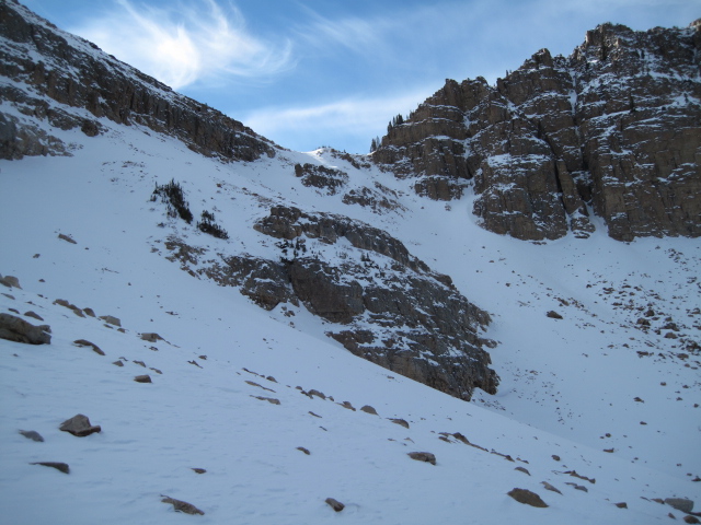
Strong winds and a good shot of snow changed the landscape overnight and the avalanche danger has risen accordingly. Now there's a cohesive piece of snow resting on several weak layers and I suspect today's avalanches will be more connected and have the potential to break deeper and wider than you might suspect. The most likely place to trigger a slide today is going to be steep, upper elevation north facing terrain, which retained snow since October. Remember- the old snow grew weak and sugary. The big ticket for today is heading to a rock free meadow that had no old snow prior to the big weekend storm.
This is what our snowpack looked like prior to the big weekend storm. Lots of weak snow for today's avalanches to break on.
|
 |
weather We should see one last shot of snow this morning with a couple inches stacking up before the storm exits the state. Strong, upper elevation winds will continue to be an issue along the ridges where they'll gust into the 60's before diminishing late this morning. Temperatures climb into mid and upper 20's before crashing into the low teens and single digits overnight under clear skies. Sunny skies and warming temperatures are on tap for the first part of the week with another small storm slated for mid week. |
| general announcements Remember your information can save lives. If you see anything we should know about, please participate in the creation of our own community avalanche advisory by submitting snow and avalanche conditions. You can call me directly at 801-231-2170, email [email protected], or email by clicking HERE This is a great time of year to schedule a free avalanche awareness presentation for your group or club. You can contact me at 801-231-2170 or email [email protected] Donate to your favorite non-profit –The Friends of the Utah Avalanche Center. The UAC depends on contributions from users like you to support our work. The information in this advisory is from the US Forest Service which is solely responsible for its content. This advisory describes general avalanche conditions and local variations always occur. I will update this advisory by 7:00 AM on Wednesday Nov. 20, 2013 |


_0.jpg)