

Avalanche Advisory
| Advisory: Uintas Area Mountains | Issued by Craig Gordon for March 30, 2013 - 6:20am |
|---|


Above treeline
Near treeline
Below treeline
|
bottom line In the wind zone at and above treeline the avalanche danger is MODERATE and human triggered avalanches are possible on steep, upper elevation, wind drifted slopes. The danger of wet avalanches is generally LOW this morning and will rise to MODERATE. Human triggered wet slides will be possible as the day heats up
|

 |
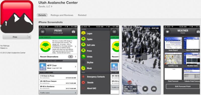
special announcement iPhone & iPad users: With help from Backcountry.com & Garafa, LLC, we now have a free mobile app that combines the best of the UAC advisories, observations, and weather summaries with National Weather Service products & UDOT road updates. This puts the tools you need for planning your day and your run in one handy mobile package. Check it out, tell your friends, and let us know what you think. http://utahavalanchecenter.org/apps
|
 |
current conditions Skies are clear, winds light and variable at 5-10 mph, and temperatures are currently in the upper 20's. Supportable snow surface and corn-like conditions will be found this morning on sunny slopes, but may have a little less longevity than yesterday due to lack of wind. On the shady slopes it's a mixed bag, but dense settled powder is still found on steep upper elevation north facing terrain. Either way, it'll be a beautiful day in the mountains!
March madness continues... the melt down is on and trailheads are feelin' the heat.
Recent observations can be found here. Wondering why last winter was so crazy? Click here to watch the 2011-12 Utah Winter Review... an excellent recap of last years conditions.
|
 |
recent activity
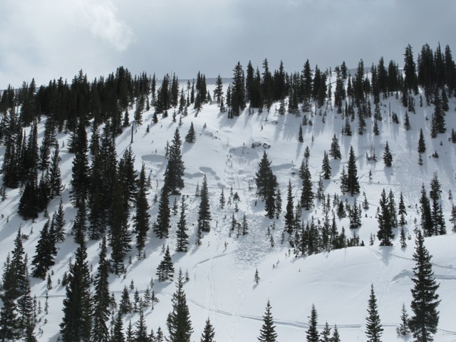
This slide in Gold Hill Basin averaged 3' deep, 175' wide, and ran 200' vertically. Triggered mid slope early in the week, the avalanche ultimately broke near the ground, failing on very weak, sugary snow. More details can be found here. Click here for recent observations from the region. |
Avalanche Problem 1over the next 24 hours
| type | aspect/elevation | characteristics |
|---|
 |
Above treeline
Near treeline
Below treeline
|
|
|
description
It's that time of year when the sun is high in the sky and it's baking nearly all aspects and elevations. As a result we generally start to transition into a spring-like pattern and wet avalanche activity palys a major role. Wet avalanches are pretty straight-forward. As the day wares on and the snow heats up, like clockwork, the pack becomes damp and wet slides and sluffs will become more widespread on steep, sunny slopes. If you're feeling like an ant under a magnifying glass... so is the snow. During the heat of the day, steer clear of terrain traps like gullies and road cuts, where even a small slide can pile up cement-like debris very deeply.
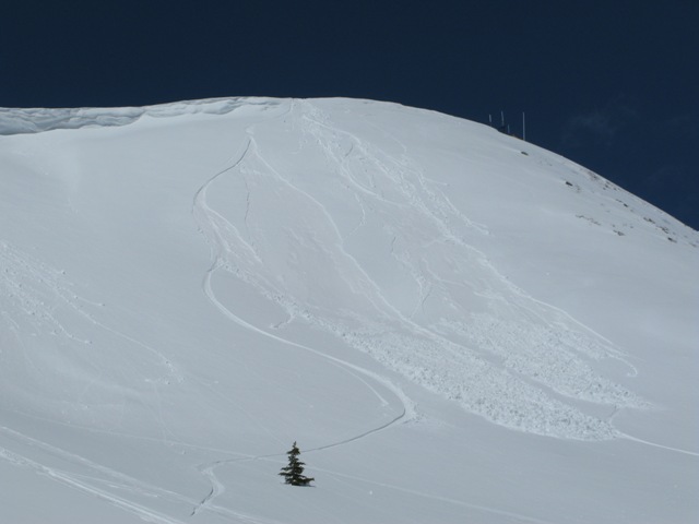
A couple small wet sluffs on the steep south face of Currant Creek Peak were triggered on Wednesday. While mostly manageable in size, the debris setup like concrete in just a matter of seconds.
|

Avalanche Problem 2over the next 24 hours
| type | aspect/elevation | characteristics |
|---|
 |
Above treeline
Near treeline
Below treeline
|
|
|
description
Cornices will become more tender with warming temperatures and may break back a little further than you might expect. Probably best to steer clear of these unpredictable pieces of snow.
|

Avalanche Problem 3over the next 24 hours
| type | aspect/elevation | characteristics |
|---|
 |
Above treeline
Near treeline
Below treeline
|
|
|
description
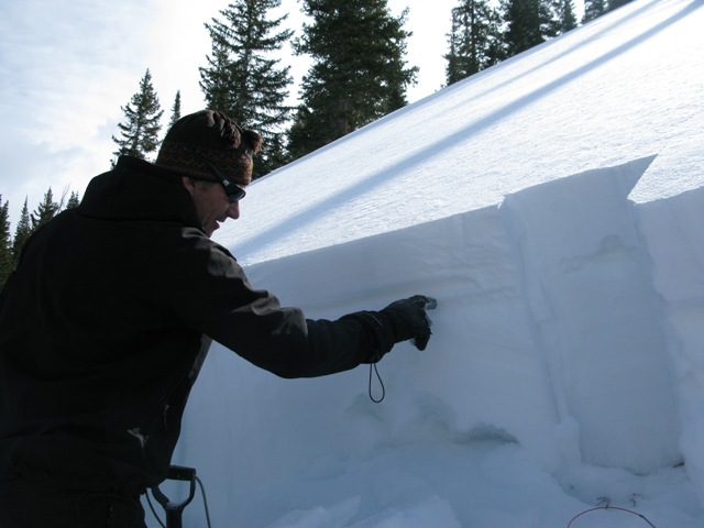
The Gold Hill slide was quite an eye opener and both Ted and I were surprised at how weak the snow was in this region. While not widespread, we've both seen similar setups in both Chalk Creek and Millcreek. The snowpack in these areas never fully developed into a thick strong pack and it took a hard hit in January as the record cold temperatures helped to both rot away and then preserve weak sugary snow, especially in upper elevation, north facing terrain. Helping to hold this mess together is a thin heat crust formed two weeks ago during the big melt down and now, last weeks storm snow is heating up and becoming a dense slab. It's snowpack 101.... strong snow on weak snow. While not widespread our usual suspect terrain comes into play and should be avoided. You know the routine... steep, rocky, upper elevation slopes, especially those that have remained thin and shallow all season.
Ted points to last weeks heat crust which is helping to hold the snowpack together, but also acting like a slab. Underneath that the snowpack is a weak, sugary mess. |
 |
weather A weak system passing to the north will bring a slight increase in ridge top winds and some cloudiness today. Temperatures climb into the mid 40's before diving into the upper 20's under clear skies. Southerly winds increase Sunday bringing warmer temperatures and increasing clouds late in the day. A Pacific system will start to move inland Sunday and will bring an increasing chance of showers Sunday afternoon through Monday.
|
| general annoucements Remember your information can save lives. If you see anything we should know about, please participate in the creation of our own community avalanche advisory by submitting snow and avalanche conditions. You can call me directly at 801-231-2170, email [email protected], or email by clicking HERE This is a great time of year to schedule a free avalanche awareness presentation for your group or club. You can contact me at 801-231-2170 or email [email protected] Donate to your favorite non-profit –The Friends of the Utah Avalanche Center. The UAC depends on contributions from users like you to support our work. The information in this advisory is from the US Forest Service which is solely responsible for its content. This advisory describes general avalanche conditions and local variations always occur. The information in this advisory expires 24 hours after the date and time posted, but will be updated by 7:00 AM Sunday March 31st. |