

Avalanche Advisory
| Advisory: Uintas Area Mountains | Issued by Craig Gordon for March 9, 2013 - 6:17am |
|---|


Above treeline
Near treeline
Below treeline
|
bottom line In the wind zone at and above treeline, a CONSIDERABLE avalanche danger exists and human triggered avalanches are likely on steep, leeward, slopes, especially those facing northwest, west, southwest, south, and southeast. A MODERATE avalanche danger is found at mid elevations and human triggered avalanches are possible on steep wind drifted slopes. If you're looking for LOW avalanche danger, head to wind sheltered terrain or carve turns on flat meadows with no steep slopes above or adjacent to where you're riding.
|

 |
current conditions Low pressure to our south produced 4" of snow across the range overnight, but unfortunately a storm diving into Arizona means northeast winds for us... this storm is no different. Northeast winds ramped up into the 20's and 30's late last night and are currently gusting into the 50's along the high ridges. Temperatures remained rather mild overnight, just dipping into the low to mid 20's. Riding and turning conditions will be outstanding out of the wind on sheltered, shady slopes. Recent observations can be found here. Our entire Uinta weather station network is up and running. A link to real-time wind, snow, and temperature data can be found here. This monumental achievement couldn't have happened without the joint efforts from the National Weather Service, The Heber-Kamas and Evanston Ranger Districts, Park City Powder Cats, and all the great work by Ted, Trent, Cody, and Al. Thanks to everyone... this is awesome! Wondering why last winter was so crazy? Click here to watch the 2011-12 Utah Winter Review... an excellent recap of last years conditions.
|
 |
recent activity
A small, recently triggered pocket breaking to weak January snow on a crossloaded gully in Chalk Creek. Click here for recent observations from the region. |

Avalanche Problem 1over the next 24 hours
| type | aspect/elevation | characteristics |
|---|
 |

Above treeline
Near treeline
Below treeline
|
|
|
description
Winds are coming from an unusual Northeasterly direction and with fresh snow to work with, they're busy forming drifts on slopes facing the south half of the compass. While easily manageable to start with, once triggered it's gonna be a different story. A fresh drift can break into weak layers of snow buried deeper in the snowpack quickly creating a large and unmanageable avalanche. In addition to direct loading on south facing slopes, today's wind will also crossload chutes and gullies on shady slopes. So there's more to today's avalanche dragon than meets the eye. Best way to avoid getting tricked is to look for and steer clear of recently wind loaded slopes, especially those that appear fat and rounded.
A perfect example of the kind of terrain that gets crossloaded by winds. One side of the chute might be stripped, while the other harbors a recent deposit of wind drifted snow.
|


Avalanche Problem 2over the next 24 hours
| type | aspect/elevation | characteristics |
|---|
 |
Above treeline
Near treeline
Below treeline
|
|
|
description
Usually sunny slopes are very predictable and avalanches break on slick melt freeze crusts formed during the warm days/cold nights. This year however, it's an entirely different snowpack on south and west facing terrain. As a matter of fact, we're seeing very weak sugary snow in the mid portion of the snowpack. And like clockwork, each time it loads with strong northerly winds, avalanches fail on this suspect weak layer, quickly stepping down to weaker snow near the ground. On the other half of the compass the pack remains suspect in steep, rocky terrain. In either case the best way to combat triggering a deep dangerous slide is with terrain selection. Tone it down a notch or two, match your terrain selection with the avalanche danger, and above all, think about the consequences of triggering a slide.
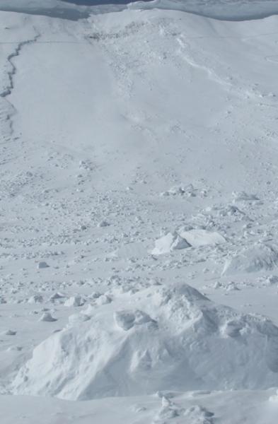
This slope took a big hit with a huge piece of cornice slamming down on it, triggering a slide that broke to weak January snow.
|
Avalanche Problem 3over the next 24 hours
| type | aspect/elevation | characteristics |
|---|
 |
Above treeline
Near treeline
Below treeline
|
|
|
description
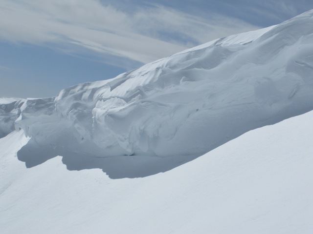
Cornices continue to grow in size and unpredictability. |
 |
weather An easterly flow over the region keep snow showers in the forecast with an additional 2"-4" possible. Northeast winds will be a nuisance, blowing in the 30's and 40's along the high ridges. Temperatures climb into the mid 20's before dipping into the teens overnight under clearing skies. High pressure builds the next few days offering sunny skies and warming temperatures.
|
| general annoucements Remember your information can save lives. If you see anything we should know about, please participate in the creation of our own community avalanche advisory by submitting snow and avalanche conditions. You can call me directly at 801-231-2170, email [email protected], or email by clicking HERE This is a great time of year to schedule a free avalanche awareness presentation for your group or club. You can contact me at 801-231-2170 or email [email protected] Donate to your favorite non-profit –The Friends of the Utah Avalanche Center. The UAC depends on contributions from users like you to support our work. The information in this advisory is from the US Forest Service which is solely responsible for its content. This advisory describes general avalanche conditions and local variations always occur. The information in this advisory expires 24 hours after the date and time posted, but will be updated by 7:00 AM Sunday March 10th. |