

Avalanche Advisory
| Advisory: Uintas Area Mountains | Issued by Craig Gordon for February 22, 2013 - 6:23am |
|---|


Above treeline
Near treeline
Below treeline
|
bottom line This mornings MODERATE avalanche danger will rise to CONSIDERABLE on steep, wind drifted mid and upper elevation terrain and human triggered avalanches are likely as the day wares on. Steep, leeward slopes facing the north half of the compass should be considered suspect. With additional snow and wind, avalanches have the possibility to break into deeper buried weak layers, producing a dangerous slide. If you're looking for LOW avalanche danger, head to low angle, wind sheltered terrain, where there are no steep slopes above or adjacent to where you're riding.
|
 |
avalanche watch We are anticipating the avalanche danger to rise this weekend. Strong winds and heavy snow will overload pre-existing buried weak layers of snow, producing increasingly dangerous avalanche conditions. |

 |
special announcement Our entire Uinta weather station network is up and running. A link to real-time wind, snow, and temperature data can be found here. This monumental achievement couldn't have happened without the joint efforts from the National Weather Service, The Heber-Kamas and Evanston Ranger Districts, Park City Powder Cats, and all the great work by Ted, Trent, Cody, and Al. Thanks to everyone... this is awesome!
|
 |
current conditions Wednesday night's storm materialized nicely, favoring the North Slope, delivering 6"-10" of of super light density snow. West and northwest winds picked up for a brief time late last night and blew 15-25 for about 5 hours. They backed off early this morning and are in the 10-20 mph range. Currently, skies are mostly cloudy, light snow is falling and temperatures are hovering right around zero degrees.The new snow is fast providing excellent riding and turning on low angle slopes. Recent observations can be found here. Wondering why last winter was so crazy? Click here to watch the 2011-12 Utah Winter Review... an excellent recap of last years conditions.
|
 |
recent activity
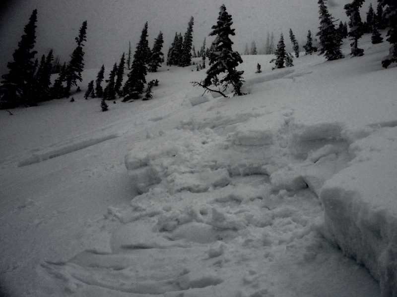
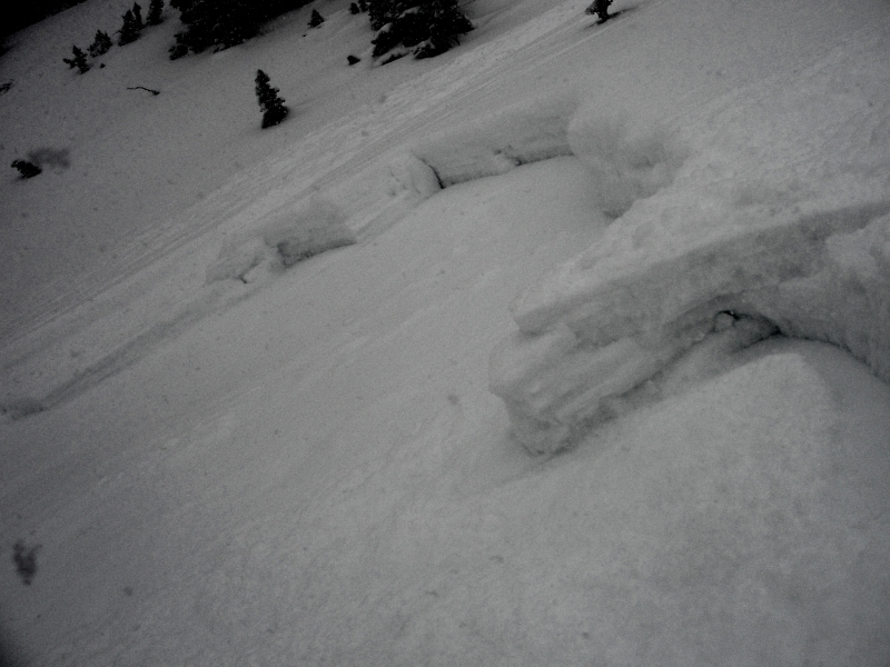
This hard slab on The Duke, located above Upper Setting Road was triggered low on slope and broke to the weak January facets. A northwest aspect at 10, 400' the slide was about a foot and half deep, 150' wide, and ran for 300' vertical. Many thanks to Michael J for all the killer info this year and for this great observation. Click here for recent observations from the region. |
Avalanche Problem 1over the next 24 hours
| type | aspect/elevation | characteristics |
|---|
 |
Above treeline
Near treeline
Below treeline
|
|
|
description
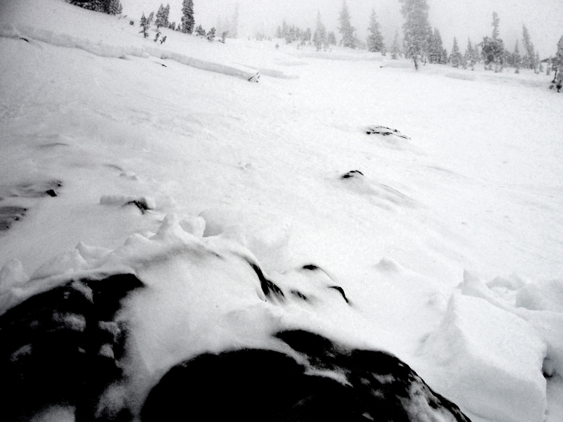
It'll be a day of changing avalanche conditions and rising avalanche danger. There's no shortage of light density snow to blow around and it won't take much wind to whip up a fresh batch of wind drifts. While not overly deep early this morning, slabs will begin to grow in size and depth as the winds increase throughout the day. As winds pick up, look for and avoid fat, rounded pillows of snow forming on steep leeward slopes facing the north half of the compass. By days end avalanches will break wider and deeper than you might anticipate and they'll be packing a punch, which can easily ruin your day by slamming you into a group of trees or carrying you over a cliff band in steep unforgiving terrain.
Not overly deep, but this slide triggered earlier this week could've easily slammed you into this group of trees, instantly ending a good season of riding.
|

Avalanche Problem 2over the next 24 hours
| type | aspect/elevation | characteristics |
|---|
 |


Above treeline
Near treeline
Below treeline
|
|
|
description
While not particularly widespread, avalanches continue to break to the weak January facets, particularly on steep, shady, north facing slopes. Adding a tricky variable to the mix is that some of our weakest snow is found mid slope, making us particularly vulnerable when climbing from the bottom or when we're low on the slope. Not every steep northerly facing slope is going to avalanche and that'll give us a false sense of snow stability. Remember- all we need to find is a weak spot in the snowpack and kick the legs out from under the slab. Best way to avoid getting tricked is to manage your terrain choices.
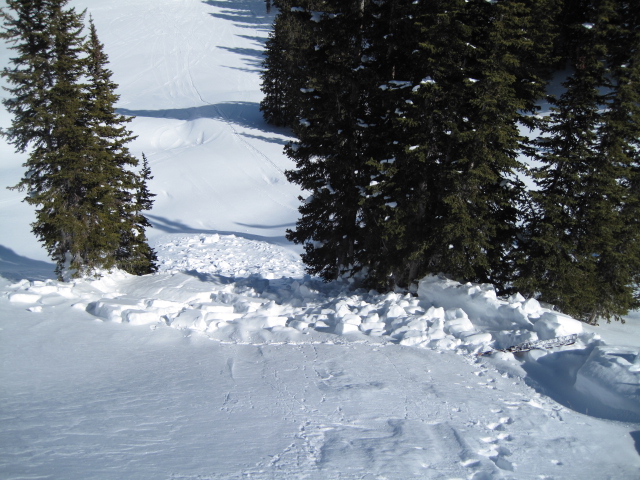
More images from yesterday's slide on The Duke. Our snowpack is relatively thin for mid February and you can clearly see this slide broke to weak snow, especially near and around rocks low on the slope. |
 |
weather A weak disturbance sliding through the region brings a few inches of snow today. Temperatures climb into the mid 20's and west-southwest winds steadily increase into the 20's and 30's throughout the day. Winds ramp up tonight ahead of the next storm and should be nuking into the 50's and 60's with gusts to 100 mph along the high peaks ahead of Saturday mornings cold front. Winds shift to the northwest midday Saturday and diminish through the rest of the day. We should see about a foot of snow with this impulse and another good shot of heavy snow is expected late Saturday into Sunday morning.
|
| general annoucements Remember your information can save lives. If you see anything we should know about, please participate in the creation of our own community avalanche advisory by submitting snow and avalanche conditions. You can call me directly at 801-231-2170, email [email protected], or email by clicking HERE This is a great time of year to schedule a free avalanche awareness presentation for your group or club. You can contact me at 801-231-2170 or email [email protected] Donate to your favorite non-profit –The Friends of the Utah Avalanche Center. The UAC depends on contributions from users like you to support our work. The information in this advisory is from the US Forest Service which is solely responsible for its content. This advisory describes general avalanche conditions and local variations always occur. The information in this advisory expires 24 hours after the date and time posted, but will be updated by 7:00 AM Saturday February 23rd. |